-2")
Remnants of Harvey Likely to Regenerate, Possible Threat to Texas
Good afternoon!
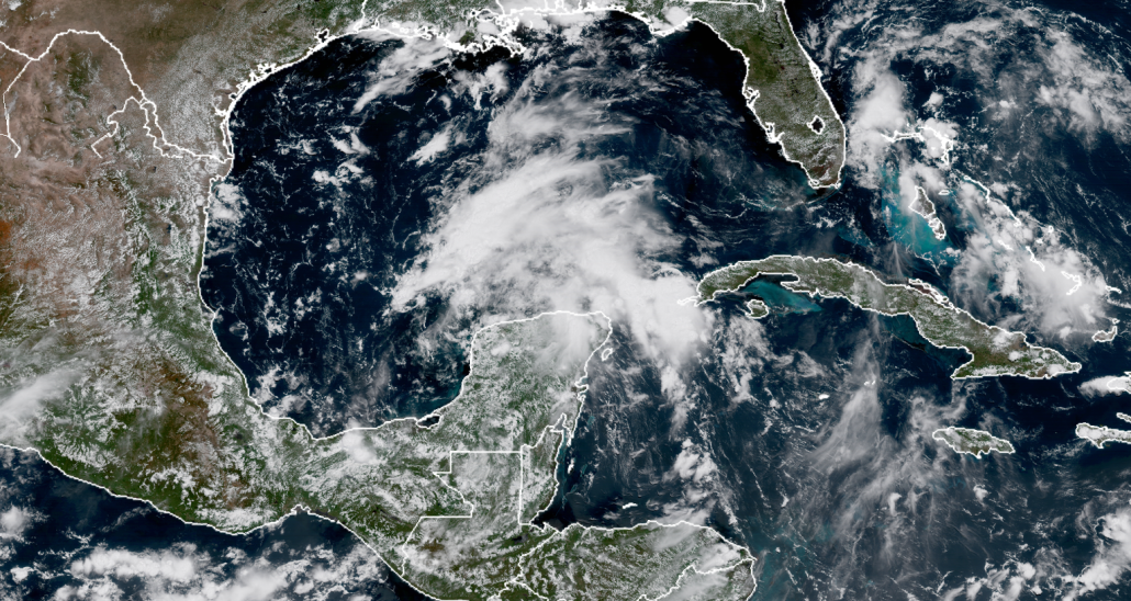
We have been closely tracking the remnants of former Tropical Storm Harvey ever since it opened up into a tropical wave over the central Caribbean sea due to unfavorable trade winds and northerly shear from a tropical upper tropospheric trough. Since that time, the remnants of the system have struggled to become more organized as the surface circulation was almost completely destroyed and the systems quick movement did not allow for it to develop a new circulation before making landfall over the Yucatan peninsula. Things have become more interesting over the past 24 hours though, as the latest model guidance is suggesting that the remnant low of Harvey will move off of the Yucatan later this evening, where conditions are favorable for tropical cyclone formation once again. The area is characterized by very warm waters in the 29-30C range, decreasing wind shear, and the overall concave shape to the Bay of Campeche which can help speed up the process of strengthening a low level circulation. On this afternoons visible satellite loops, we can see a very distinct spin to the low level clouds over the Yucatan, and this area also corresponds to an increasing lobe of 850 vorticity. While the circulation is likely not closed off, it certainly has become more defined over the past 12 hours, and is a strong indicator that this system will at least try to reform.
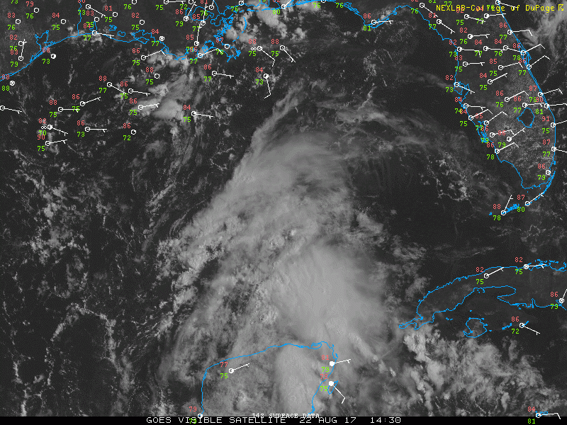
This afternoons visible satellite loop showing a very well defined spin over the Yucatan peninsula. Harvey is forecast to be back over water this evening.
With that said, development will likely take a little while and will not be immediate, as the overall structure of Harvey is still rather broad. Deep and sustained convection will likely need to develop over the low pressure area before any kind of well-defined surface circulation forms. Once a low level circulation can become established, gradual strengthening is expected, and it appears possible that this system could become a tropical storm on Thursday when it will be located over the open water of the Gulf. The intensity forecast for this system remains quite difficult, as the upper level low that originally killed Harvey may stick around long enough to provide some light to moderate wind shear over the system, which could cause the system to become lopsided and broad in nature. If this occurs, then the system will likely take its time to strengthen over the next few days.
On the other hand, some models like the earlier runs of the GFS have the upper level low backing away to the west and dying off quicker in response to the development of very cold convection from Harvey. This would leave the developing system under very light shear conditions with a strengthening upper level anticyclone as the system continues to produce more cold convection. This would favor a more rapid strengthening pace, and was favored by some of the earlier models. At this time, it seems likely that the upper level low will remain somewhat coherent enough to impose some light to moderate shear early on in the redevelopment stages of this system. This solution is also favored by the most recent hurricane-specific models, but we will need to closely monitor any trends or changes over the next 12-24 hours. Additionally, NOAA will be conducting numerous flights to collect observation on not only the remnants of Harvey, but also the overall condition’s in the Gulf of Mexico (starting this evening). This data will likely cause a shift in the models, but at this juncture, it is too early to say in what way it will affect them.
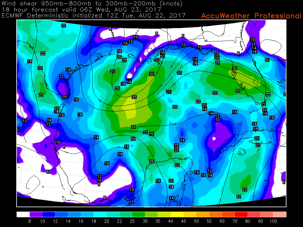
This afternoons ECMWF model showing the ULL to the north of Harvey holding on just enough to prevent the development of an upper level anticyclone in the short-term
In terms of track, the models have shifted away from their earlier ideas of the remnants heading to central Mexico, and have instead latched onto Harvey gaining more latitude thanks to a weakness in the ridging to the north. After the system exits the coast of Mexico this evening, a general NNW heading is expected over the next 4 days or so. By this time, things become a little more complicated as a very large ridge over the west will prevent any further westward movement. This could cause the system to stall over Texas after landfall, which would pose a very significant rain threat for the area. At this time, it appears that the rain threat with this system will be the main story as some of the models like the GFS and ECMWF have been printing out over 36″ of rain over a 48 hours period. Even the more conservative HWRF and CMC have 16-24″ of rain, which is more than enough to cause very significant flooding. This will have to be monitored very closely since the slow motion of the system and the constant moisture feed from the very warm Gulf has been something that the models are very attainment about at this time.
The future of Harvey after the day four and five period become significantly more uncertain as the models begin to disagree about the location of the system and the overall synoptic pattern. Some models keep Harvey stalled for around two days over Texas, then gradually move it to the east and back over the Gulf. Others have the system gradually weakening and moving inland over the southeast, while still dumping very heavy rainfall amounts. This is yet another aspect of this system that will need to be resolved over the next day or so, but we may have to deal with this system for a while if it does indeed redevelop.
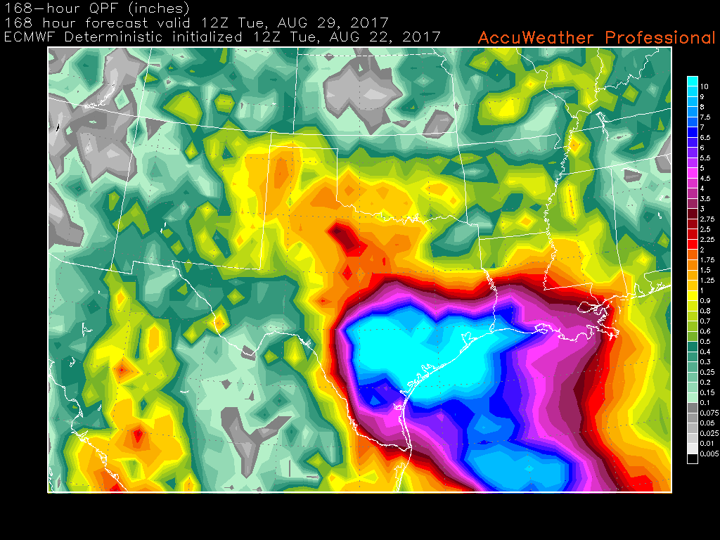
This afternoons run of the ECMWF model showing the potential for extremely heavy rains associated with the redeveloping remnants of Harvey
All in all, Harvey is likely to redevelop into a tropical storm by Thursday morning, and has the potential to gradually strengthen in the Gulf of Mexico over the next few days before making landfall along the Texas coastline. There are great uncertainties regarding strength, but we should have a better idea once the system is better organized and sampled by NOAA/USAF. We will have an update likely tomorrow evening.
Have a great evening!
Steve Copertino
Trackbacks & Pingbacks
2meaningless
Comments are closed.