-2")
Major Hurricane Irma Threatens South Florida This Weekend
Good evening! Hurricane Irma remains an extremely powerful Category 5 storm, and is now moving just north of Hispaniola. It will continue to move west-northwest into the Turks and Caicos Islands later tonight. Irma is then expected to track somewhere between the Southern Bahamas and Eastern Cuba on Friday. There are still some uncertainties in its track over the next 24 hours, but we are starting to gain a model consensus on the systems eventual future. Chances are growing that Irma will be a major hurricane impacting South Florida on Sunday. Major impacts from Irma are also likely for other parts of Florida and the Southeast US.
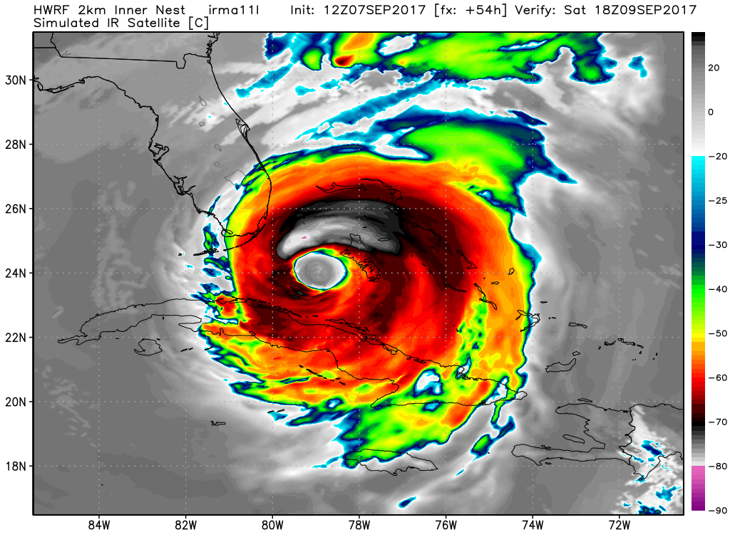
Irma has continued to remain resilient over the last couple of days, despite encountering some mid-level shear, as well as having its inflow being disrupted by the mountains of Hispaniola. Irma has not weakened very much, as winds only have decreased from 185 mph to 175mph and pressure has remained around 921mb. Irma has remained at Category 5 strength for the longest period of time ever recorded in the Atlantic Basin. Eyewall replacement cycles that seemed to begin have just resulted in Irma’s inner eyewall merging with the outer eyewall. This is instead of the inner eyewall collapsing and the outer eyewall contracting again, which is more typical and would result in more weakening, during the cycle.
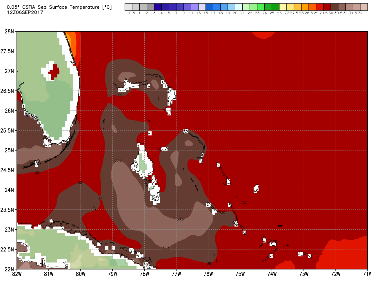
At this time, Irma is situated over very warm water with temperatures between 29°C and 30°C. But by Friday night and Saturday it will be moving over even warmer sea-surface temperatures around 30° C to 31°C, between 75W and 80W, near Cuba and the Bahamas. This will provide more fuel from latent heat energy for Irma. The storm will also likely be underneath an upper-level anticyclone with low shear and embedded in a moist, unstable airmass with theta-e advection that supports good outflow in all sides. As a result of these favorable conditions, there may be a period of rapid intensification later Friday into Saturday. Then Irma may start to undergo more southwesterly shear, as the mid-latitude trough begins pulling out of the Southeast US. Thus, the storm may begin a weakening trend as it nears the South Florida coast.
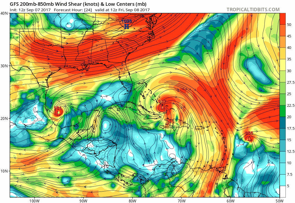
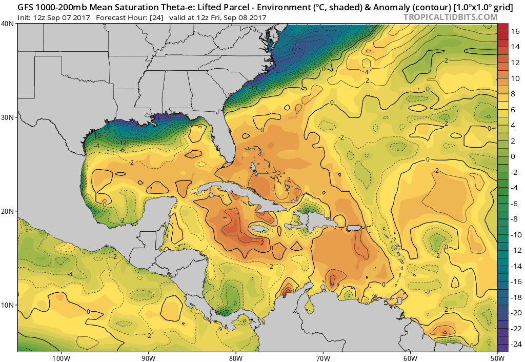
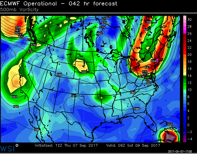
GFS model with an upper-level anticyclone providing low shear and a good outflow pattern over Irma, while it’s between the Bahamas and Cuba. Then southwesterly shear vectors increase as Irma nears South Florida (Tropical Tidbits).
However, it will still likely be a major hurricane of at least Category 3 or 4 status, capable of causing extensive or extreme damage from high winds. Typically, the strongest winds are in the northeast quadrant of the eyewall. So where exactly the storm makes landfall, or moves very close to land, will be crucial for figuring out the path of the most destruction. Regardless, sustained hurricane force winds or gusts may still impact parts of the Florida Peninsula by Saturday night and Sunday. Thus, hurricane watches have been issued for South Florida and the Florida Keys. Also Irma will cause large swells that can lead to a destructive storm surge, especially around high tides. Latest storm surge forecasts are for 5 to 10 feet along parts of Southeast Florida coast. Then depending on where Irma turns northward, it could also bring hurricane force winds to much of the coastline from Georgia to North Carolina later Sunday night into Monday. So hurricane watches may be extended further northward by tonight or tomorrow.
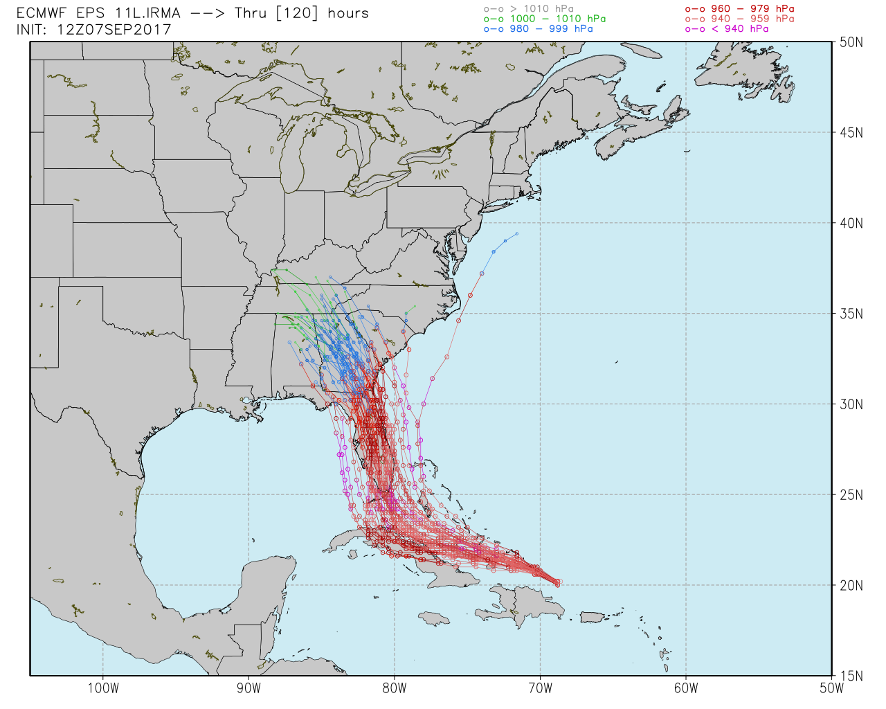
Model guidance still shows some differences on how much of a weakness will exist in the sub-tropical Western Atlantic ridge that the full-latitude trough leaves behind. There is also some additional shortwave energy undercutting the ridge over the Plains, that may interact with Irma and steer the storm farther west. Some models such as the GFS, show the full-latitude trough deeper over the Northeast, and the Plains shortwave energy weaker. Thus the Northeast trough has more influence and causes the storm to turn to the north-northwest before reaching the Southeast Florida coast on Sunday, and Irma tracks into Georgia or South Carolina by Monday.
Other forecast models like the ECMWF suggest that the aforementioned shortwave energy will be a little stronger and dive further south into the Northern Central Gulf region. This will allow the energy to have some subtle influence on Irma, causing the system to take a more west-northwest track into the Florida Straits before turning north-northwest into South Florida or the Florida Keys on Sunday. The storm will continue moving north-northwestward either inland over the Florida Peninsula or near the Florida Gulf Coast. Given the delicate nature of synoptic features and the remaining spread in the model guidance tracks, everyone in Florida and Southeast US coast still needs to prepare for some major impacts. However, the 12z ECMWF ensembles this afternoon, offer strong support for a further west solution on the ECMWF model over the Florida Pennisula.
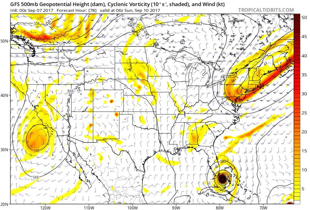
The ECMWF model more robust with Central Plains shortwave energy interacting with Irma and influencing more a westerly track over the Florida Straits before turning north-northwestward into South Florida
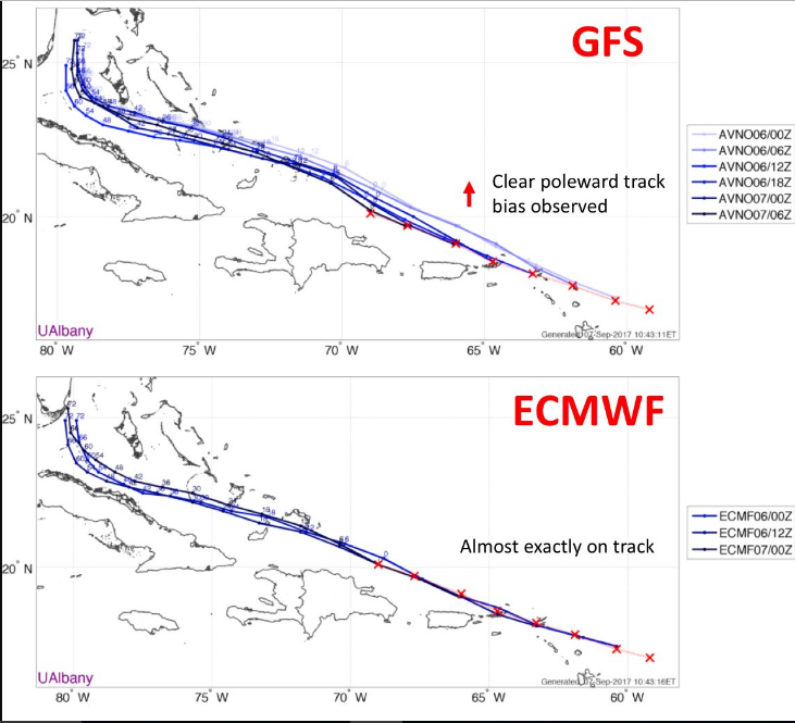
Additionally concerning is the fact that while the GFS had been trending stronger with the Northeast US trough on Wednesday’s runs, it has now reversed that trend and become more progressive with this trough in today’s runs, a movement towards the ECMWF guidance. Additionally, the GFS has had a clear poleward bias with Irma over the past few days, while the ECMWF has been steady in predictions of Irma’s track. (map via Brian Tang) This recent evidence lends credence to a potentially devastating scenario for Florida, where Irma makes landfall near the Florida keys and then heads due northward through the state. Miami would be in the northeast eyewall and face a worst-case scenario, and considering the narrow width of the state and the wide radius of hurricane-force winds, the entire width of South Florida could have major hurricane-force winds, and the rest of Florida could have category 1-2 hurricane-force winds.
On Monday, Irma will be much weaker, but still is likely to dump heavy rainfall as it moves inland over Northern Florida, Georgia or South Carolina. The storm will be moving pretty steadily, so we aren’t anticipating a prolific rainfall and catastrophic flooding like we saw with Harvey in Texas. But several inches of rainfall are still likely with significant flash and river flooding possible in some areas. There is also potential for some severe weather, especially on the northeast side of Irma. Strong directional shear and a moist, unstable tropical airmass could support a few tornadoes. This weather is very typical of most landfalling tropical cyclones.
Irma’s remnants will continue to move northward into the Tennessee Valley and/or Mid-Atlantic regions by the middle of next week. But its remnants will be decaying as it runs into more subsidence from high pressure and upper-level ridging. Threats for flooding rainfall and severe weather will be lessening by the time its remnants reach the Ohio Valley or Northeast US.
Stay tuned for more articles and/or videos on Hurricane Irma’s impacts over Florida and the Southeast US. We continue to keep a close eye on the latest guidance, observations and significant changes with Irma’s structure. Also, clients or premium members please the check the tropical weather dashboard for the latest information, including NHC forecasts, satellite images and model plots for all the hurricanes currently in the Atlantic basin. We are continuing to monitor Hurricane Jose in the Central Atlantic that could threaten the Northern Leeward Islands as a major hurricane again next week. Hurricane Katia, currently stationary in the Western Gulf of Mexico, will be a threat to the Veracruz region in Mexico.