-2")
Watching the Remnants of Hurricane Irma Over Georgia
Good Evening!
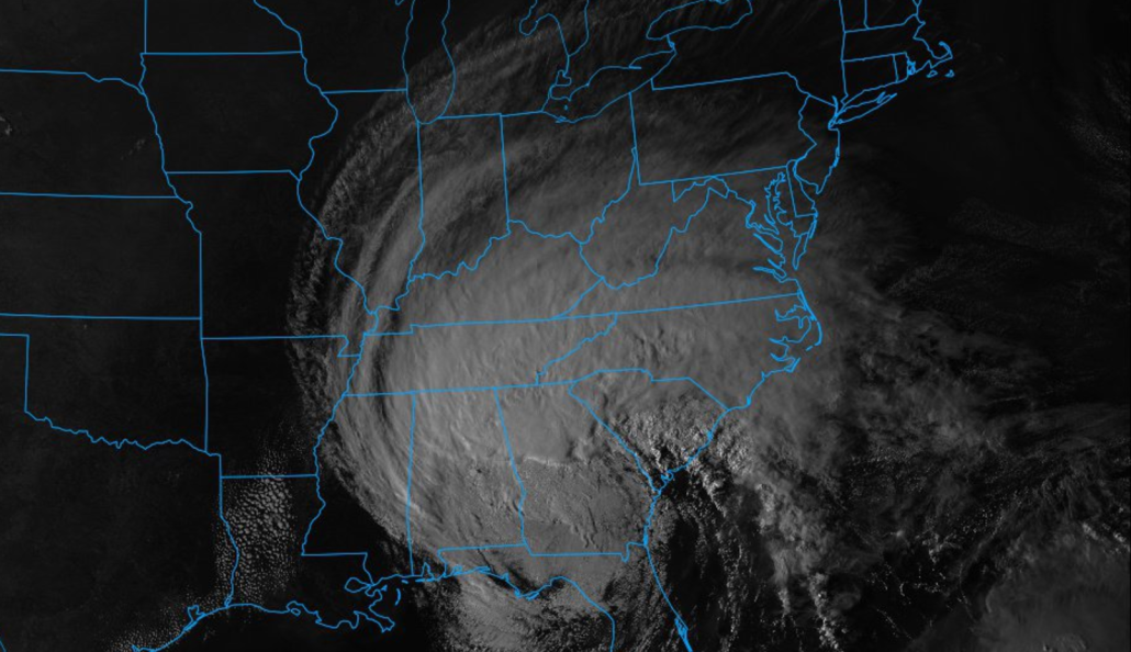
Hurricane Irma battered the Florida peninsula yesterday, first making landfall on the Florida Keys as a Category 4, then again later in the day near Naples as a Category 3. Though information is still rolling in on the extent of the damage in the state, it is pretty obvious that the entire state of Florida has been affected to some degree. After its final landfall in Florida, the storm began to expand its radius of tropical storm force winds quite a bit as the mid level system from Canada began to interact with the hurricane and started some extra-tropical processes. This only worsened the already massive storm surge that the hurricane carried with it during its long trek across the Atlantic. Places as far north as Charleston experienced storm-surge related damage, as well as power outages from Irma’s massive circulation. As is common with many intense hurricanes when they hit land, the amount of momentum that the storm had built up over the past two weeks will take some time to spin down, and that has been very evident today on radar and satellite. If we look at radar images from the south, we can see a large area of rotation associated with the decaying low level circulation of Irma, as well as the more pronounced mid level circulation. This mid level circulation has been responsible for mixing down strong wind gusts to hurricane-force today across portions of the southeast, causing tree damage and numerous power outages.
Irma will continue to weaken over the next day or so, as it makes its way into the Tennessee River valley by Tuesday afternoon. The storm will be fully-extra-tropical (meaning that other process are sustaining the wind and convection and the storm in no longer fed by its warm-core) and quite large in nature. Showers and thunderstorms should extend all the way from Arkansas to portions of the southern Mid-Atlantic states like Virginia and Maryland. Some of the stronger showers and storms may be able to mix down some residual tropical storm strength gusts, and will also be capable of producing tropical downpours which may caused localized flooding of poor drainage areas and perhaps on roads. There is also a risk of tornadoes with any cells coming in from the feeder bands over the Atlantic. There have been some strong signatures observed over water during the past 24 hours, and a tornado watch has been issued for portions of the Southeast.
Please check with your local NWS office to stay on top of any watches or warnings that may be issued once the NHC declares the storm “post-tropical” and hands over the tracking to the folks at the Weather Prediction Center.
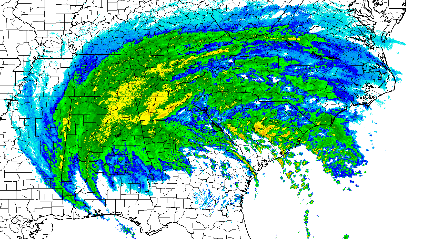
Hi-res Base Reflectivity imagery of the remnants of Hurricane Irma over the Southeast US
As Irma winds down late Tuesday and into Wednesday as the low begins to fully occlude and fill in, a warm front will progress from west to east over the Mid Atlantic states, and eventually into the Northeast. This front will begin to slow as it moves through Pennsylvania on Wednesday, due to the residual high pressure system just off the coast of the Mid Atlantic. This will cause numerous showers to form over the area, but as tropical moisture begins to fade, these showers should be on the more typical side, with steady rain and generally cloudy conditions expected.
As of right now, the most unsettled day across the eastern half of the nation appears to be on Thursday, when a little more surface heating may take place just ahead of the main area of mid level energy, and this could create a marginally unstable air mass supportive of weak thunderstorms and isolated downpours. Friday may feature more showers and possibly some thunderstorms over much of the Mid Atlantic and Northeastern states, but the overall area of coverage will depend on just how strong the mid level energy remains as it meanders over the next few days. Dry conditions may return this weekend, as an area of high pressure begins to build in from the west, which should kick the remnants of Irma out of the area and allow for more stable and clear conditions.
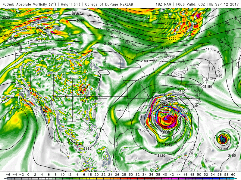
Evolution of the mid level remnants of Hurricane Irma over the next few days as it meanders across the eastern third of the country
Hurricane Jose Wandering Over the Open Atlantic
Hurricane Jose is still out and about over the Atlantic, located to the north of Hispaniola and Puerto Rico. Jose has been experiencing significant wind shear due to the very rapid expansion of Irma’s outflow once it began to undergo an extra-tropical transition. Even in the face of this shear, the storm has been able to maintain hurricane intensity, and currently has winds of around 100 mph. The storm may continue to weaken as it begins to execute a very complex loop over the next few days due to a break-down of the steering currents from the remnants of Irma. This pattern is forecast to last until Friday or so, when the hurricane will once again be located just north of the Bahamas. It is at this point that the models begin to diverge significantly. Some models have the storm taking a hard right and heading out to sea, and others have Jose maintaining a more westerly motion by this weekends, which would put it uncomfortably close to the southeast US. This scenario would result in the storm also encountering more favorable conditions for re-intensification as an upper level high would be allowed to rebuild overhead.
While it is much too early to say what the overall outcome will be, there is plenty of time to watch this storm as it churns over the open waters of the Atlantic, with the only concerns being increased wave action and rip-tides. We will have more on this storm regardless if it becomes a legitimate threat to the east coast over the next few days!
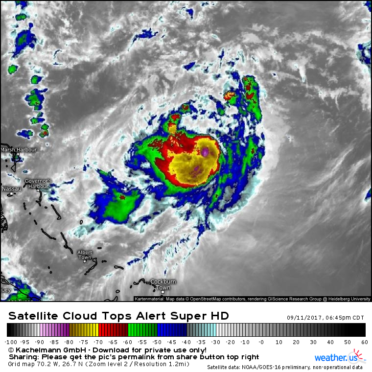
Latest GOES 16 IR imagery showing Jose getting beaten up by shear from now Tropical Storm Irma’s outflow (courtesy of weather.us)
For more information and posts like this one, make sure you sign up for Premium Forecasts — where multiple detailed articles, videos, and interactives are posted each day. Also, come interact with our staff and many other weather enthusiasts at 33andrain.com!
Have a great evening!
Steve Copertino