-2")
Showers and Thunderstorms Possible, Hurricane Jose Still Meandering Over the Open Atlantic
Good evening!
Today was a transitional day for much of the area, as the remnants of Hurricane Irma and another mid level system congealed over the Ohio Valley, and worked to produce widespread cloudiness and isolated showers today. While this area of showers is mainly concentrated with the main mid-level system over the Ohio Valley, a warm front will be pushing in from west to east as we talked about last time, but looks to significantly slow once it crosses the Pennsylvania/New Jersey area as it feels the leftover high pressure just off the mid Atlantic coast. This warm front will have some small amounts of lift associated with it still, so showers will be possible for the remainder of the evening, with some showers having locally heavy downpours. The overall threat for heavy rain should be mitigated somewhat by residual subsidence and dry air, but any areas that experience these showers should expect a quick 20-30 minute period of at least steady rain. The combined factors look quite poor for any kind of flooding conditions, except for some very isolated ponding on roadways in the absolute heaviest showers.
Regardless, temperatures were able to get into the upper 70’s to lower 80’s across the area, despite some cloud cover in spots. One thing that was quite noticeable this afternoon and into the early evening hours, was the marked increase in low level humidties over the region. This due partly to the large breadth of leftover tropical air that has since collapsed outwards from the remnants of Irma and has since become entangled with the warm front. As we head into the overnight hours, the threat for showers will gradually diminish with time, and it appears the vast majority of the area should remain dry. Due to the increased low level moisture, it appears that overcast conditions and even some patchy fog will be possible, especially inland. Tonight’s conditions will be quite poor for radiational cooling to take place, so expect temperatures to stay in the low to middle 60’s for lows this evening.
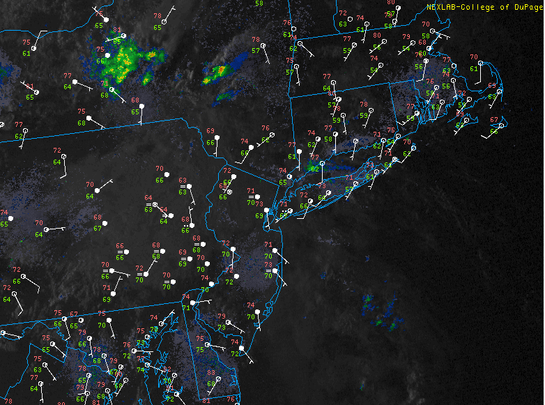
This evenings latest high resolution visible satellite imagery, regional radar mosaic, and surface observations, showing only a few areas of showers lingering over the area (Courtesy of College of DuPage)
Thursday Into Saturday
After meandering and festering over the Ohio valley for over two days, the large mid level trough associated with the remnants of Hurricane Irma will finally begin to lumber on east. This mid level system should continue to increase mid level moisture over the area, with PWATS nearing the 1.5 to 1.8″ range. Depending on how much sunshine the area can get tomorrow, it is possible that the area can destabilize a bit, with 500-1500 joules/kg of SBCAPE possible. With the increased moisture, surface instability, and small amounts of enhanced lift from the mid level system, widespread shower and thunderstorm development may be possible as we head into the early to mid afternoon hours tomorrow. This activity would mainly be focused in a corridor from eastern Pennsylvania, southern New York, and fading into the NYC and Long Island area. Shear will be quite meager with this decaying mid level system, so no severe thunderstorms are likely tomorrow. We may however see some isolated strong showers and thunderstorms capable of producing gusty winds, heavy rainfall, and very small hail. Additionally, these storms are expected to have a low threat of flash flooding due to their modest forward speed and PWATS being on the lower side of what we would want to see for any kind of flash flooding. Storms should reach their peak for the western areas around mid to late afternoon, with the activity translating to the NYC metro by late afternoon and into the evening. By this time, any stronger storms should have begun to weaken considerably at this point. Highs during the day will be in the upper 70’s to lower 80’s once again, with a muggy feel to the day.
Friday looks to be quite similar as the decaying mid level system pushes the last of its energy over the region. This should allow the slow-moving frontal boundary to move directly over the region during the afternoon hours on Friday, leading to more possible shower and thunderstorm development. Daytime heating and instability should pool up to the point where the meager amounts of lift should be able to trigger showers and an isolated thunderstorm to form over the area during the late afternoon hours, into the early evening. At this time, it appears that the greatest coverage for any showers and thunderstorms will be just to the north of the NYC metro area. Highs should once again reach into the upper 70’s to lower 80’s over much of the area, with lows ranging from the lower to middle 60’s.
By Saturday, a weak area of high pressure is expected to form over the area, providing an opportunity for warmer and drier conditions to take hold. Most of the Northeast should remain mostly sunny with light winds and high clouds during the weekend, possibly lasting into the early portions of next week.
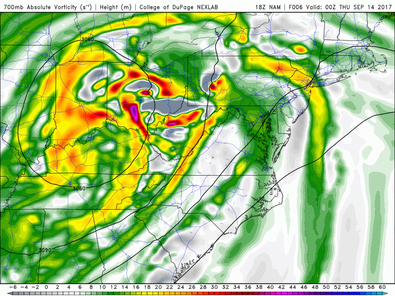
NAM model showing the decaying mid level trough moving over the area, potentially sparking a few round of showers and thunderstorms
Hurricane Jose
Jose is still meandering over an area between Bermuda and the southern Bahamas. Jose currently has winds of around 75 mph, just barely making it a hurricane. The system is still experiencing some strong vertical wind shear, separating the mid level center from the low level center, which is inhibiting any kind of strengthening, and should continue to do so until it can find a more favorable environment, if it ever does. Jose has completed a cyclonic loop and should begin to head off to the North starting tomorrow. The vast majority of the models take Jose well out to sea, but there have been some model runs showing an area of high pressure developing over Jose as it tries to escape out to sea. Instead of continuing north, the system slows down and begins to head westward towards the east coast. This is occurring in the Day 6-8 period on the models, so continuity and reliability is very low, and not much stock is being put into these operational runs. Only a minority of the EPS members show Jose making it to the US east coast, and such a scenario is extremely unlikely. Regardless, we will monitor the progress of Jose over the next few days. We will have an update on the system by Friday afternoon!
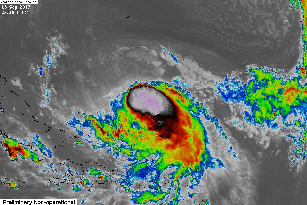
This evenings latest GOES 16 infrared imagery of Hurricane Jose, showing the storm located north of Puerto Rico with very cold cloud tops and a sheared appearance to the system. Jose should track generally north over the next five days or so.
For more information and posts like this one, make sure you sign up for Premium Forecasts — where multiple detailed articles, videos, and interactives are posted each day. Also, come interact with our staff and many other weather enthusiasts at 33andrain.com!
Have a great evening!
Steve Copertino