-2")

EPO ridging a sign of changing pattern across USA
A pattern in fluctuation has led to several changes in sensible weather conditions across the Continental USA over the past few weeks. Stagnant warmth gave way to several shots of cold air, first affecting the Northern Plains and eventually leaking southward into the Tennessee and Ohio River Valleys. The change in wavelengths and increased amplitude led to the development of a few significant storm systems; namely one which brought snow to the Upper Midwest, and another which delivered damaging winds and torrential rain to the Northeast.
The hemispheric pattern is set to change again as we approach the middle part of this week, with appreciable changes already occurring in the Pacific Ocean. As we discuss quite often, what occurs in the Pacific Ocean from the Bering Sea towards the Gulf of Alaska (more affectionately known as the North Pacific) can often have major implications on the weather in the USA. There are other factors to consider, always, but we can often look there for clues, and the coming weeks will be no different.
Forecast model and ensemble guidance is in good agreement that a large ridge will develop in the North Pacific Ocean, in a region used to monitor the “Eastern Pacific Oscillation” or EPO. This oscillation has been used for years to correlate the propensity of arctic air to move southward in Western Canada and often times into the Northern 1/3 of the United States. Typically, when the EPO moves into a negative modality, a ridge builds in the North Pacific Ocean, disrupting the flow of arctic air and sending anomalous cold southward into British Columbia and then the Northern USA.
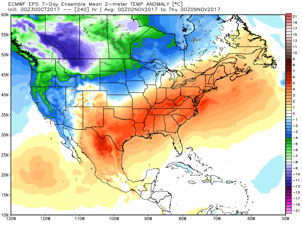
ECMWF ensemble mean showing above normal temperatures on average from the Southern Plains to East Coast, and below normal temperatures on average from the West Coast to Northern Plains during the first 7-10 days of November
A similar ridge is expected to develop over the next several days, and forecast models and ensembles are in good agreement that anomalous cold will quickly slide southward on the East side of this ridge into British Columbia and the Northwest USA. This cold will leak eastward into Montana and the Dakotas, as well as the Northern Plains towards Minnesota and Iowa. In fact, most ensemble guidance indicates a very high probability of prolonged below normal temperatures in this region.
But what about areas further east? This is where the difference between the Pacific and Atlantic becomes so critical. Although cold air is being displaced southward on the Pacific side of the country, what about the Atlantic side? The answer lies in the North Atlantic Oscillation (NAO) and Arctic Oscillation (AO) regions, and neither of them are currently supportive of high latitude disruption. In other words, there is little support in the hemisphere for cold air to move eastward with any vigor across the United States. In order to get cold air to persist east of the Mississippi River, often times a –NAO or –AO is necessary to disrupt the flow of cold in the arctic latitudes in Central and Eastern Canada.
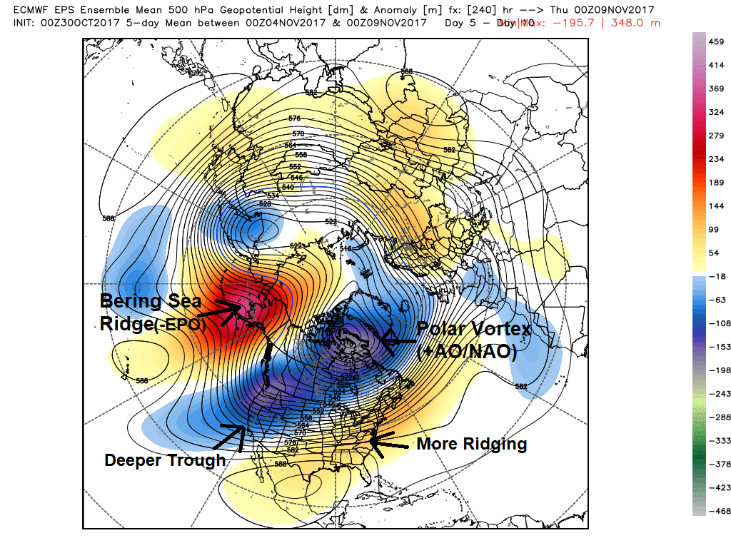
ECMWF ensemble mean 500mb height anomalies, showing a negative EPO and positive AO/NAO pattern in the high-latitudes, supporting deeper troughiness over Western US and more ridging over Eastern US during the medium-long range period
Without any high latitude ridging in these regions, cold air will weaken in intensity and modify as it moves eastward through the country. The best low level cold air source will remain in the Northwest USA and British Columbia. Even more importantly – the wave height pattern will support the development of a ridge in the Southeast USA, supporting warmer than normal temperatures East of the Mississippi River. This is a classic La Nina type pattern!
While the longevity of these patterns almost always remains somewhat uncertain, forecast models are in good agreement that the –EPO ridge anomaly will remain stagnant for several days at the very least. This should support a continuation of the above mentioned “look” to the weather pattern, with cold air bottled to the northwest and warmer air lingering in the East/Southeast USA. As the EPO ridge collapses towards Mid November, some potential will exist for cold air to leak eastward into the Great Lakes and New England.
Stay tuned for further updates to the forecast over the next few days!
Trackbacks & Pingbacks
2intermittently
Comments are closed.