-2")
Why might forecast models be diverging with the long range pattern?
Good morning! The past several days have been quite active in the meteorological community.We began last week on the tail end of a pattern featuring stagnant warmth, with ridging in the Eastern United States and cold air bottled up in Western Canada and the Pacific Northwest. A well advertised change has occurred since that time, however, with cold air surging southeastward into the Great Lakes and Northeast States.
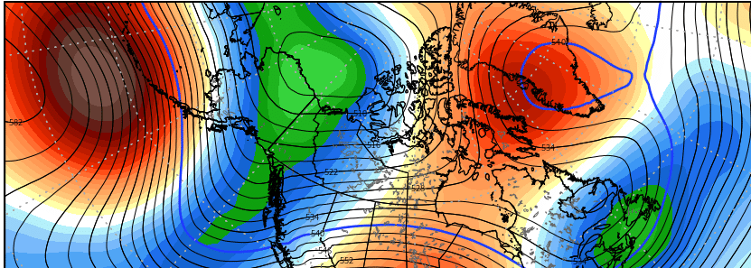
Much of the change can be attributed to the presence of high latitude blocking, which continues to develop in earnest as we speak. Ridging has built northward into the Pacific Ocean towards the Arctic regions, extending all the way near the North Pole. Meanwhile, another ridge is forecast to develop near Greenland over the next few days.
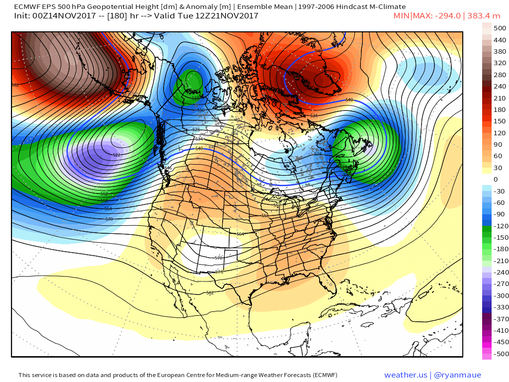
ECMWF Ensembles showing strong high-latitude blocking developing with a ridge Greenland and upper-level low over Southeast Canada, by early next week
These high latitude ridges are so critical to the forecast process, especially when monitoring the movement of airmasses across the United States. See, ridges in the high latitudes act to dislodge cold air that typically resides in the arctic regions, further south. While the movement of the airmasses isn’t always linear (each event behaves differently than before), we can use the positioning and intensity of high latitude blocking to predict where the cold air will go.
Over the next several days, at the very least through the meat of the Week 2 forecast, high latitude blocking and its lingering effects will keep colder than normal air over the Great Lakes and Northeast States. This will be particularly exacerbated by a strong storm system which will impact New England and the Great Lakes this weekend. Cold air will be pulled southward behind the storm as the storm system loops over Southeast Canada. This will result in lingering colder temperatures a +GWHDD over these particular regions.
But what happens thereafter? High latitude blocking is, after all, still a feature of transience. While the atmosphere can feature faster and slower things (and blocking is a slower thing, for sure) all things continue in motion. And high latitude blocking will eventually move away, either to be replaced — or to not be replaced at all. That is where the forecast gets complicated.
Forecast models are diverging significantly during the Day 10 to 15 period in regards to how the remnant high latitude blocking transitions. This will be the critical component in understand how the height pattern behaves across the United States. Analyzing each individual forecast model can give us clues, but looking deeper into the pattern itself, meteorologically, is always a better idea.
Two of the best indicators as to how the atmosphere will behave are ENSO (La Nina, El Nino) behavior (sea surface temperatures, upwelling and subsurface temperatures) as well as the MJO (Madden Julien Oscillation). Both of these oscillations which are monitored in the Tropical Pacific and Indian Ocean heavily affect the circulations across the globe. The MJO, in particular is monitored in “phases” based on where convection is located in the Indian Ocean.
The MJO is currently forecast by most global dynamic models and ensemble forecasts to reemerge from a “non-eventful” stage (inactive or non-impactful) into Phases 4 and 5 with considerable amplitude. This suggests the MJO will begin to have a heavier influence on the global circulations. Historical analogs of the MJO in Phase 4 and 5 during moderate to strong amplitude during the month of November suggest a pattern that heavily promotes the development of warmer than normal air across the United States. However, the presence of high latitude blocking could mitigate this warmth somewhat, especially at the onset of global circulation effect from the MJO wave.
Considering both the forecast MJO wave amplitude, continued presence of a La Nina base state in terms of the effects on global atmospheric circulations and wave patterns, and the presence of high latitude blocking in Canada, Greenland, and the Arctic regions, the forecast moving forward should begin to consider some of the warm risks which are appearing on the ECMWF and ECMWF EPS guidance suite.
However – there should be some caution in terms of “full blown warmth” development across the United States, particularly across the Northern 1/3 of the country, as it relates to GWHDD and similar monitoring tools. The pattern across the Pacific Ocean will continue to “battle” any attemps at warmth, mitigating what otherwise would be large-scale warmer than normal anomalies.
Stay tuned over the next 24-48 hours as we continue to monitor the latest data and observations across the globe. Also stay tuned, as always, for the latest maps and discussions in our PM briefing document.