Tuesday PM Update: Frigid temperatures arrive, snow chances ahead

Good evening! Are you cold yet? High temperatures today throughout the Northeast ranged from the 20’s to lower 30’s, well below normal for late December. Even colder weather is on the way for the rest of the week, so get ready to bundle up and dress in layers. A few storm chances will likely follow – and we’ll dive into the forecast model depictions, including which make sense and which don’t.

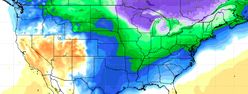
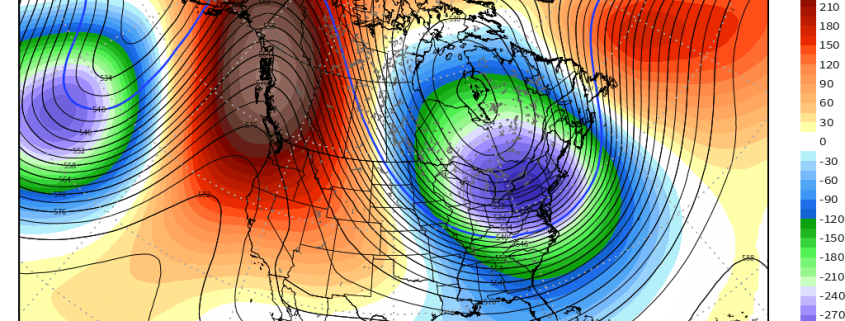
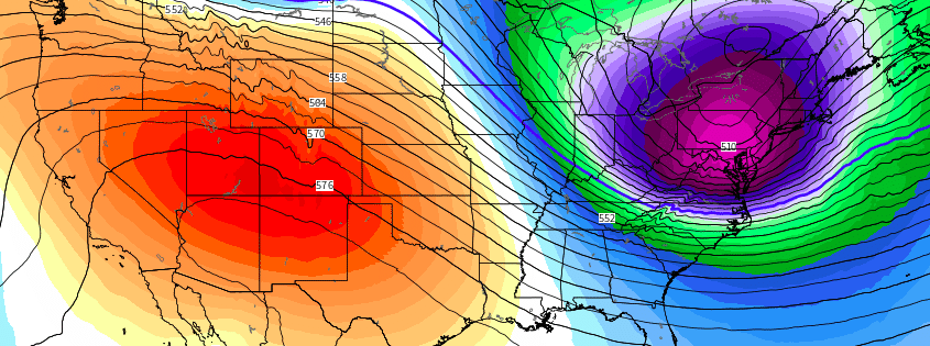
For tonight, arctic high pressure will build over the Northeast states, supporting mostly clear skies and calmer winds. Temperatures are likely to drop into the teens overnight many areas – some of the interior valleys (including the Pine Barrens) may drop into the single digits. Forecast models suggest the core of this airmass, characterized by 850mb temperatures between -20 and -25 C, will move over the Northeast states late this week. High temperatures will fall all the way into the teens and lower 20’s, with single digit temperatures overnight.

Read more

The importance of the EPO and upcoming cold risks

For some time now, we have discussed the likelihood that colder than normal air would be a common theme in the Northern and Eastern United States during the month of December. Like most things, it was not expected to be constant, but it was expected to be prevalent, and especially when compared to the past few December’s which featured nearly coast-to-coast anomalous warmth in the United States.

After a warm start, colder than normal air invaded the Great Lakes, Ohio Valley and Northeast during December’s second week. Winter weather threats have followed, with many areas recording multiple snowfalls. While this airmass hasn’t broken records, it has been just as anomalous as advertised, and has had an obvious impact on markets and businesses. After a brief period of moderation, forecast models are beginning to signal the return of arctic air into the USA – and this time it may be more anomalous than before.

Read more

Long Range Update: Cold Intensifies, Active Pattern to Follow

Good evening! As has been heavily advertised for a while, a pattern change to cold is now imminent, and should be able to sustain itself for a couple of weeks thanks to retrograding and deepening troughing near the Aleutians. This leads to continued downstream impressive responses near the West Coast, with plenty of latent heat release and poleward ridging. This will dislodge a couple of shots of Arctic air into the Eastern two thirds of the US — into a lot of the major markets.

While the first shot of colder air later this week and weekend will be impressive in some spots, it is the second shot of colder air around the middle of next week that should be much more impressive, as it will truly have an Arctic source region, thanks to the poleward ridging. There will be a nearly direct pipeline due north to south from the Arctic for this cold air to plunge towards the US.

The above video explains this progression and highlights the significance of this cold. We also discuss the potential for moderation late in the month, and how the Pacific Jet extension that may cause this moderation could lead to a major winter storm somewhere in the East as we get closer to the Holidays. Additionally, we discuss the potential for other winter storms in the more near future, though their significance may be limited by a lack of good wave spacing.


Extremely Amplified Pattern Will Set the Stage for Arctic Cold

Good evening! The changes to the pattern have been discussed for a while, but now that the model data has finally caught on, things are starting to truly get interesting and we can entertain possibilities.

An initially very zonal pattern will quickly become very amplified thanks to changes with a train of waves in the Pacific and a traffic jam of waves building in the Atlantic. Eventually this forces an amplified ridge in the Pacific to build towards the Arctic and dislodge plenty of cold into the Eastern half of the US, as the corresponding deep trough will have nowhere to go thanks to the aforementioned traffic in the Atlantic.

The video below has all of the details on the coming cold, its severity, and potential duration. It also discusses potential winter storm threats that may arise in the pattern.

Read more