-2")
Tuesday PM Update: Frigid temperatures arrive, snow chances ahead
Good evening! Are you cold yet? High temperatures today throughout the Northeast ranged from the 20’s to lower 30’s, well below normal for late December. Even colder weather is on the way for the rest of the week, so get ready to bundle up and dress in layers. A few storm chances will likely follow – and we’ll dive into the forecast model depictions, including which make sense and which don’t.
For tonight, arctic high pressure will build over the Northeast states, supporting mostly clear skies and calmer winds. Temperatures are likely to drop into the teens overnight many areas – some of the interior valleys (including the Pine Barrens) may drop into the single digits. Forecast models suggest the core of this airmass, characterized by 850mb temperatures between -20 and -25 C, will move over the Northeast states late this week. High temperatures will fall all the way into the teens and lower 20’s, with single digit temperatures overnight.
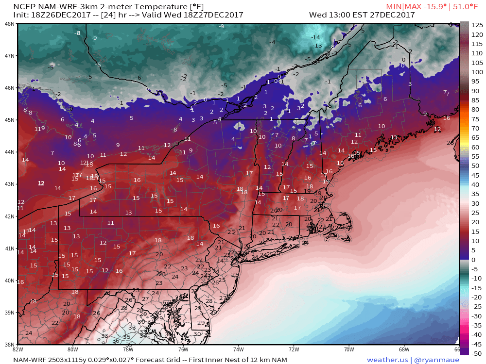
3km NAM temperatures in teens and lower 20s Wednesday afternoon in the Northeast
While the initial shot of cold air is likely to begin to lift out of the Northeast late this week, another reinforcing shot of cold air will enter the picture by New Years, potentially exacerbated by the development of a storm system off the East Coast. Forecast models are a mess in terms of the storms evolution; some are closer to the coast, while others are much farther offshore. One thing is for sure: There are multiple disturbances in the atmosphere, and a piece of the polar vortex will drop southward into the Northeast states to interact with them.
As it currently stands, it appears most likely that this interaction will occur well offshore. Despite the lack of consistency among forecast models, the weather pattern remains slightly progressive across the United States, mainly thanks to an active pattern in the Eastern Pacific. We’ll lean towards the more progressive solutions for now, with a major snowstorm currently appearing unlikely for any of the Big Cities of I-95. Lets take a look at how things could evolve:
A piece of the tropospheric polar vortex (the troposphere is where most of our sensible weather occurs) is forecast to interact with a disturbance over the Eastern United States. You’ll see this evolution below – watch near hour 114-132 as the two pieces of energy begin to interact. The interaction could be enough to produce lift int the atmosphere to support some precipitation near the Mid Atlantic and Northeast states, as well as a weak low pressure system.
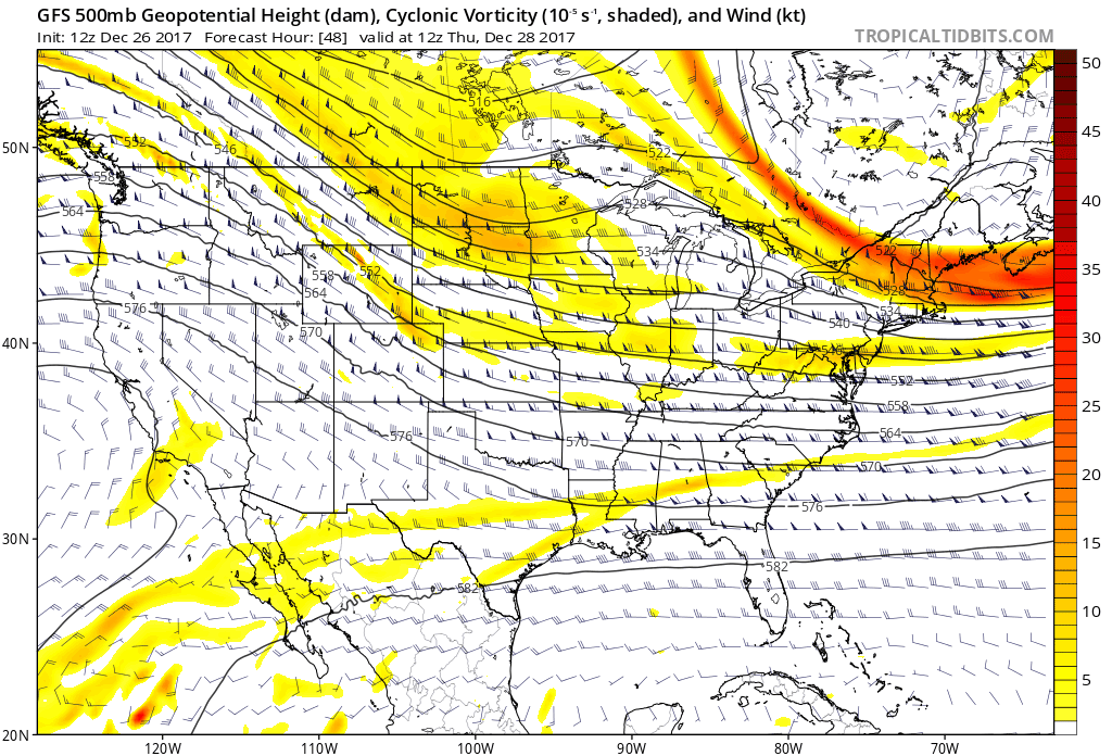
GFS forecast model 500mb heights and voriticy evolution between 48 to 156hrs. More energy digs southwest for bigger east coast storm developing for New Years.
Other forecast models suggest this interaction will occur different. The ECMWF, Canadian, and UKMET forecast models suggest a larger piece of the tropospheric polar vortex will drive southward, creating a more amplified storm system. This could develop a stronger low pressure system off the coast – potentially bringing bands of heavier snow closer to the coast, particularly across parts of New England. The European, for example, develops a strong coastal storm just off the New England Coast that then moves into the Gulf of Maine.
The issue with this solution is the nature of the hemispheric pattern around it – which remains quite progressive. There is a brief window for a disturbance to amplify, and these forecast models are suggesting that this tropospheric polar vortex will phase with an incoming shortwave during this exact window. It remains a lower probability event in our eyes, but if it were to occur, a low pressure system could rapidly form offshore. Given their geographical position, the event would favor parts of New England for snowfall of significance, while a lighter or more moderate snowfall would occur further west.
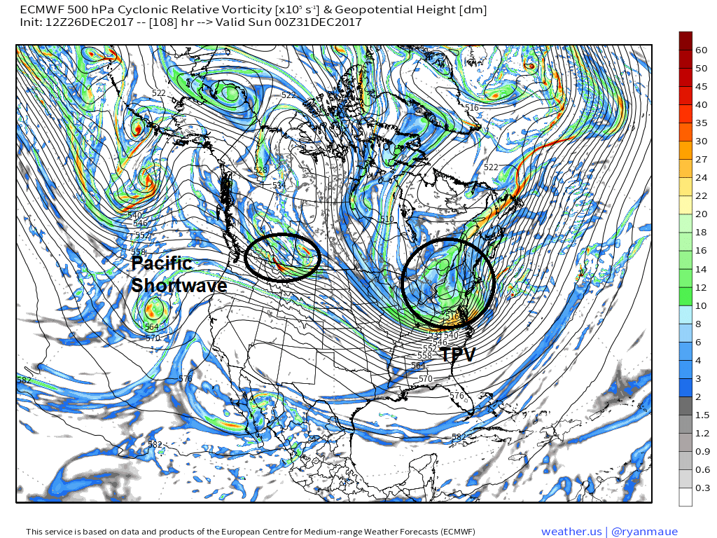
ECMWF model showing the TPV digging into Northeast, while another shortwave comes into the Pacific Northwest, causing the PNA ridge to flatten
We’ll keep an eye on it over the next few days, but our current forecast leans to the progressive side with this storm system, with the potential for light snowfall in the Northeast states and the stronger storm system remaining offshore. The main weather story in the Northeast states around New Years looks to be cold – and as the tropospheric polar vortex drops in, some the coldest air of the season will follow suit. Temperatures could be extremely cold during this time frame, with the ECMWF Ensemble indicating the potential for low temperatures near zero.
The next threat for a storm of significance looks to come around January 3-5, when the ECMWF Ensemble and GFS Ensemble are indicating a more supportive Western US ridge for amplification, and the potential for coastal storm development. We’ll be watching carefully.
For now, bundle up..
Article written by Miguel Pierre and John Homenuk
Trackbacks & Pingbacks
1commented
Comments are closed.