-2")
First Accumulating Snow of the Season Becoming Likely for the East Coast
Good afternoon! In the world of weather, there has been a lot of model mayhem regarding a big shift in the data further northwest with a coastal storm, which is leading to the idea of accumulating snow across much of the Eastern US on Saturday. We believe that these ideas have a lot of merit, and in this article we are going to explain why, as well as overview some of our expectations.
In the macro sense, it’s not a complicated setup. We have a large ridge in the West, and a corresponding deep trough in the East, we have disturbances sliding down the ridge and entering the trough, and we also have a relatively stalled frontal boundary off the coast, providing a strong temperature gradient for a storm to ride, while also providing enough ridging in the Atlantic to keep the storm from sliding out to sea.
But in the finer details, it’s actually a very complicated setup. This is because of the orientation of the pieces of energy/vorticity involved that are phasing together. The ridge has become so amplified and meridional (due north-south orientation) that one piece of energy is digging all the way into the Gulf. This is a good thing for a storm to amplify, because it means the storm can fire off convection and latent heat release with the warm Gulf, which leads to a feedback effect of more ridging out ahead of it.
However, since it is digging all the way into the Gulf, it also slows down somewhat. While this allows the second piece of energy diving into the Midwest to catch up with it and phase together, it also leaves for a very delicate situation. This second piece of energy is actually part of the Polar Vortex, and pieces of the Polar Vortex generally do not phase very well with other pieces of energy. Instead, they can compress storm systems and take on their own height fields and shunt the height field of any developing storm. This is what we saw on previous model guidance that was sending the storm out to sea.
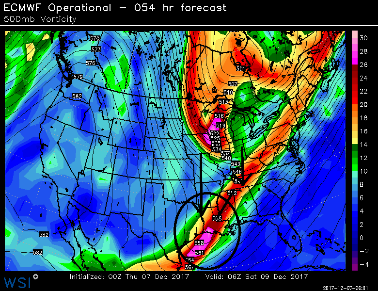
The European model from last night, which showed no snow. Notice how the polar vortex piece in the Midwest is aligned directly with or even just east of our southern shortwave. Also notice how strung out the southern shortwave is, as well as how its amplification gets compressed by the vortex’s height field in the Tennessee Valley. (WSI Model Lab)
What is occurring now, however, is that the positioning and orientation of this energy is changing. The second piece of energy is diving down a tad further west, which is giving a bit of a “boost” to the southern shortwave. What this does is allow the southern shortwave to move just ahead of the second piece of energy, so the ridging downstream of the second piece and connect with the ridging ahead of the shortwave, and thus the disturbances can phase together and amplify the entire pattern. If the southern shortwave remained behind the second piece, then the second piece would’ve squashed it, and the vorticity field would have become strung out as well.
Now that the southern shortwave is just ahead of the second piece of energy, it also gives itself more room to remain its own singular entity somewhat, which means it has its own vorticity field. This means that it can advect its vorticity into downstream areas where there is little vorticity — and thus positive vorticity advection. It’s the advection of vorticity that leads to precipitation and low pressure development, not vorticity itself. In the more strung out scenarios, the vorticity was simply advecting into areas where vorticity was already there because it was so strung out over a large area, and thus no positive vorticity advection.
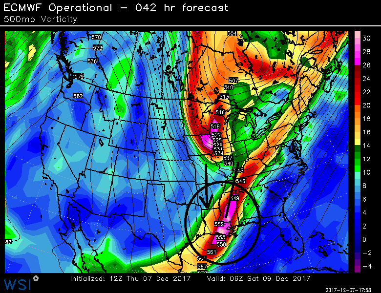
Today’s European model, which showed a solid snowstorm. Notice how how the southern shortwave is slightly east of the vortex piece. Also notice how much more amplified the southern shortwave is and now it’s not getting compressed, and how its height field ahead of it is aligned with the ridging ahead of the vortex (WSI Model Lab).
Another significant synoptic feature is a very strong upper-level jet streak between 200-300mb. It’s running at nearly 200kts(!), which is well above climatology averages. This type of upper-level jet has been observed prior to many major snowstorms along the East Coast, according to research from Heather Archambault. Model guidance shows that coastal sections of the Northeast and Mid-Atlantic region will be in the right-entrance region of this jet streak, where the upper-level divergence is highest.* This leads to strong lifting for pivoting, banding precipitation, which will likely be in the form of mostly snow due to very cold air aloft. This also causes low pressure to deepen more and track further north and west, as well as expand precipitation well north and west from the storm’s center. All model guidance continues to trend stronger and more amplified/NW with this jet.
*Upper-level divergence is important because that means air is spreading out aloft, but to retain mass balance, that means air has to rise underneath this spreading air. With a lot of rising air, that can mean precipitation on its own, but it can also lead to enough lift to actually lower surface pressures, since the pressure on the ground is lower when air is rising/being “released” via the divergence aloft. Think of it like when you open a soda can and a lot of the air escapes — the pressure inside the can is being lowered. Additionally, to retain mass balance for a lot of rising air, that means air at the low-levels has to convergence, meaning additional lifting mechanisms for precipitation. Considering this jet streak is near record levels of intensity, this upper-level divergence could be quite significant and lead to moderate to heavy bands of snow on Saturday evening. And as this jet continues to trend westward on model guidance, that leads to more upper-level divergence further west as well, and thus the snowier trends on all of the latest data.
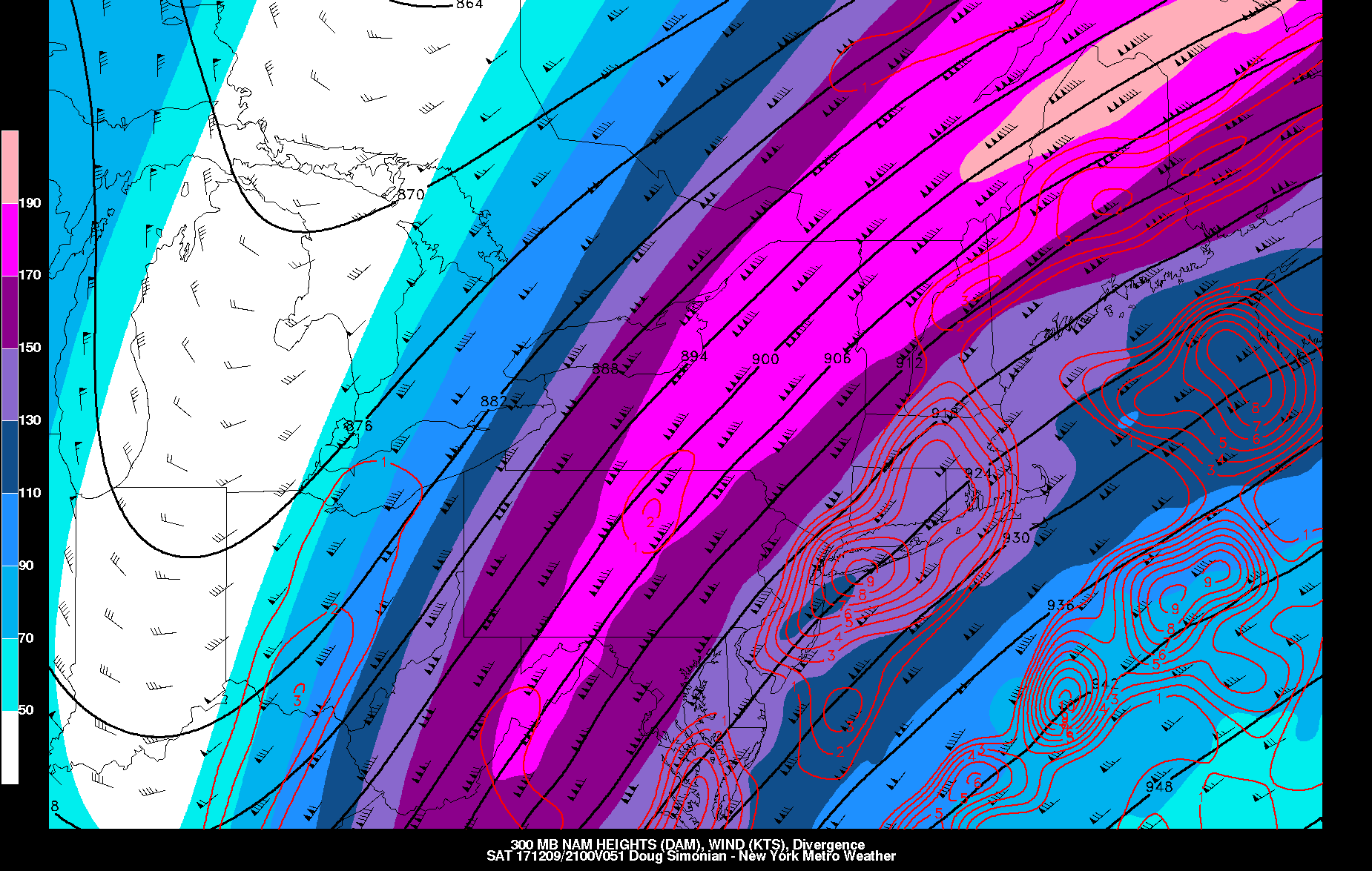
The NAM is showing showing strong divergence in the right-entrance region of the 300mb jet over coastal sections of New England and the Northern Mid-Atlantic on Saturday evening.
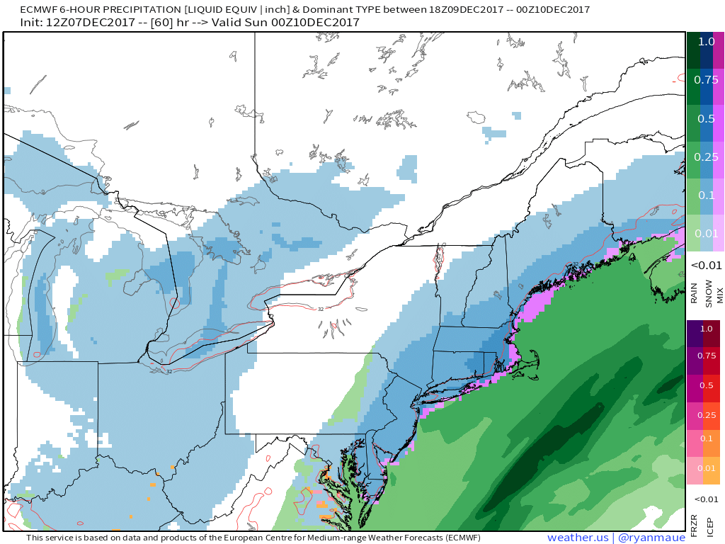
As a result, it appears that we will see our first accumulating snowfall for the I-95 corridor cities and coastal sections of the Northeast and Mid-Atlantic this weekend, with a few to even several inches of snow possible in some spots. Stay tuned for more updates on this storm through tomorrow, as we continue to monitor trends on the latest model guidance. Also visit the 33andrain forms for more discussion on this winter storm!