-2")
Tuesday Briefing: Snow exits, wintry and colder pattern awaits
Every so often, we come across a storm that is quite humbling for meteorologists – one that defies most of our common practices and goes against the grain of what we are expecting. Last nights storm system was exactly that, as we expected the storm to pass mostly without fanfare. Just yesterday, regional observations and short term model guidance suggested the system would pass fairly harmlessly seaward, with light snow along the coast and Long Island with light accumulations on the East End.
As you may have already heard, much more than light accumulations occurred, with parts of Eastern Long Island reporting 6-9″ of new snowfall — a significant, warning criteria winter weather event. While these numbers were relegated to the Eastern part of Long Island, their occurrence was significant in its own right, as our forecasters were not anticipating numbers anywhere close to those to occur. As it turns out, forecast model guidance did a very poor job in resolving mesoscale features of the storm system, which allowed banding to pivot further westward and develop last night with moderate snowfall on Long Island. Another learning experience for all involved, in a profession that requires near constant learning to stay ahead of the curve – which we intend to do.
Here are some of the latest snowfall totals for last nights event.
As we move forward into the middle part of the week, the weather will become a bit more benign, with calm high pressure settling in and keeping temperatures seasonable in the Northeast states. This will be short lived, as an active pattern will develop very quickly, with a reshuffle of the weather pattern in the Pacific Ocean leading to a crescendo in cold and stormy weather over the next two to three weeks.
The first in a series of wintry weather threats will come during the tail end of the week, as a weak frontal system passes through the Northeast states. Forecast models suggest trailing moisture along this front could lead to a mixture of rain and wintry precipitation, with wintry precipitation on the back end of the frontal zone on Friday. A zone of light snowfall could blanket the Mid Atlantic and Northeast states on Friday morning as the front shifts through, ushering in arctic air.
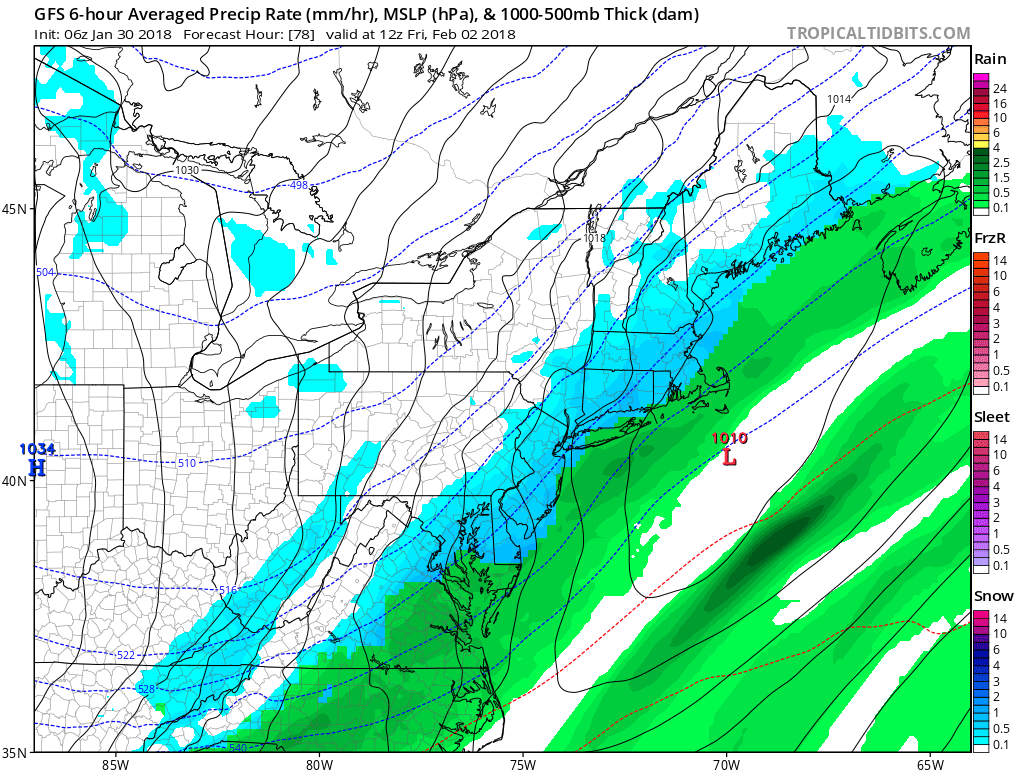
GFS model suggesting the development of snow on Friday morning.
Another threat then evolves during the upcoming weekend near Super Bowl Sunday, when forecast models suggest a moderately strong disturbance will eject through the Mississippi River Valley and towards the East Coast. Exactly how this disturbance behaves and interacts is still up in the air – but the potential exists for a light to moderate wintry weather event in the Northeast States if the system can “turn the corner” and amplify near the coast, aiding in the development of a low pressure system offshore.
The GFS, ECMWF and Canadian model guidance have all hinted at this to some extent, but to varying degrees. A weaker and more progressive system would result in minimal impacts, while a more organized system could result in moderate winter weather impacts with a more recognizable low pressure system developing. We’ll be keeping a close eye on trends among ensemble guidance as we move through the next few days.
Here are the weather highlights, in case you wanted an abbreviated version:
- We significantly under forecast snowfall amounts on Long Island last night, where 6-9″ of snow fell.
- Calmer weather returns over the next few days in the Northeast states.
- A light wintry threat occurs Thursday PM through Friday AM, as a front passes by with light accumulations possible from the Northern Mid-Atlantic into New England.
- Another event approaches the Northeast from Sunday into Monday, and could be more impactful depending on how organized the system becomes.
- Wintry threats with cold air will continue in the East through the middle part of February.