Mild and Unsettled Pattern Begins to Take Shape
Good evening!
The dreary and wet conditions that took over back on Saturday afternoon have finally begun to break as a cold front pushed through the Northeast this morning and early afternoon. Rainfall amounts were in the moderate range for most of the Mid Atlantic and Northeast, with locations closer to the immediate coast seeing totals in the 2-4″ range. Widespread was not recorded due to most of the Mid Atlantic and sections of the Northeast actually being in a drought do to a lack of any substantial precipitation over the past few months. Luckily, this recent rainfall was very beneficial to the area, and may have been able to knock some locations back to around normal precipitation departures. Regardless, most of the area saw their Monday start off rather mild, with highs being recorded in the morning hours over a large portion of the Northeast. This was due to a cold front that has been lagging begin the main system which actually pushed offshore last night with the remaining bulk of the heavy rain. As this cold front moved through portions of the Northeast, the cold air was quick enough on the backside to catch up to the remaining precipitation and cause a very brief mix of rain/snow/grauple. These spotty areas of mixing were quite light and brief in nature, so no accumulations were recorded. Conditions became rather calm, with even some patchy sun showing up for the middle and later afternoon hours, as temperatures over the region leveled off in the upper 30’s to lower 40’s. Conditions should remain quite dry, but occasionally a bit gusty as drier Canadian air filters into the region tonight. A strong area of high pressure will also be gradually building in over the Northeast from west to east, so this will ease winds overnight and cause clouds to gradually subside. Lows should be rather cold, with location around the NY metro area likely seeing temperatures in the lower to middle 20’s, with locations off to the north and west likely getting down into the teens with good radiational cooling.

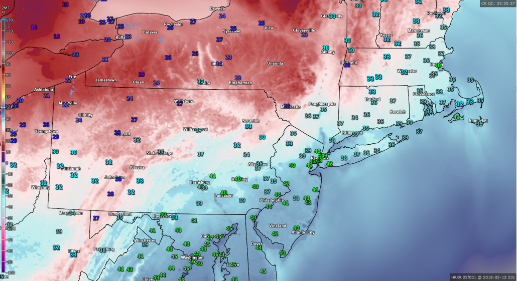
This evenings latest surface temperatures from the HRRR with surface observations and the regional radar mosaic showing a rather calm, but cooler night taking shape
Tuesday Into Thursday
Tomorrow should start off rather clear and cold, as the aforementioned strong high pressure system continues to move over the Northeast. A fast zonal (west to east) jet streak will still be dominating the pattern across the entire country. This mean that any system over the next couple of days will be moving very quickly across the United States, with no time to amplify or strengthen. This will be the case throughout the entire day on Tuesday as some shredded-off energy from a decaying system over the west moves into the Mid Atlantic and Northeast. This energy is too insignificant to cause anything other than some high-level cirrus clouds during the afternoon hours tomorrow as the jet stream roars overhead. Highs tomorrow should be rather seasonable, with temperatures likely staying in the middle to upper 30’s, with some locations off to the south of the city possibly getting into the lower 40’s. Tranquil conditions will last well into the evening and overnight hours, as radiational cooling allows lows to drop once more into the middle to upper 20’s, with locations off to the north and west in the lower 20’s.
Mid level ridging will begin to build over the Plains during the day on Wednesday, leading to southwesterly flow increasing quite a bit over the Mid Atlantic and Northeastern states. This will begin to cause the classic response of mid level temperatures rising as well as moisture beginning to stream northward from the Gulf of Mexico. Showers and thunderstorms will likely begin to develop over the Southeast Wednesday afternoon, with some of that moisture possibly making it into the central parts of the Mid Atlantic before dark. Conditions will likely turn at least mostly cloudy during the day as increased moisture leads to the development of mid level clouds over much of the Northeast. Despite the clouds, temperatures should be quite mild, with highs likely getting into the middle to upper 40’s, with some locations likely hitting the lower 50’s. The threat for some showers will gradually increase as the night goes on, with showers likely moving in around 10pm or so for the New York metro area. Lows will be much more tame on Wednesday night, with readings likely staying in the upper 30’s to lower 40’s.
Thursday will be the first much above normal day in the period as a trough over the Western US states continues to cause the downstream strengthening of ridging over the East. Moisture from the Gulf will continue to move northward over the entire Northeast, likely leading to a wet start to the day on Thursday. As mentioned earlier, the mid level disturbance responsible for this rain will be so disorganized and moving so quickly that only light rainfall amounts are expected. The exact temperature forecast is a little complicated at this time and will depend on just how quickly the rain showers will be able to move out, but it certainly looks like highs should be able to rise well into the upper 50’s and lower 60’s across much of the Mid Atlantic and southern portions of the Northeast. Conditions will likely remain unsettled with spotty showers possible throughout the rest of the evening and overnight hours, as another in a series of weak disturbances pass through the Ohio Valley

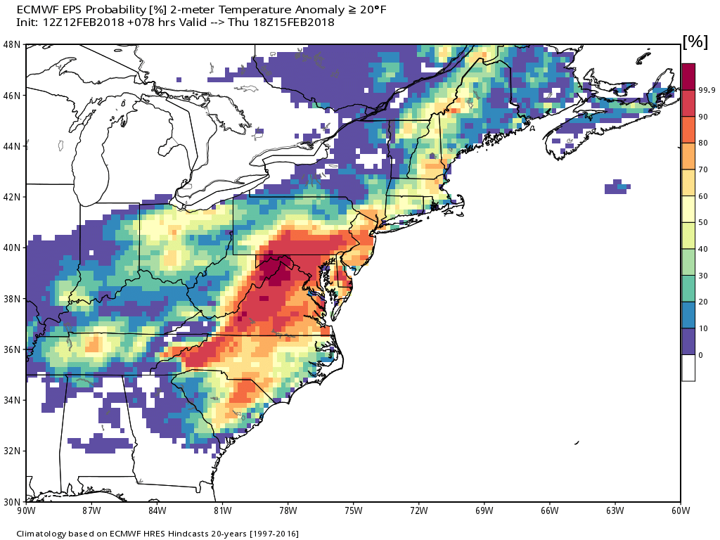
This afternoon European ensembles showing a high probability of temperature anomalies reaching 20 degrees above normal on Thursday!
Mixed and Mild Weekend Ahead
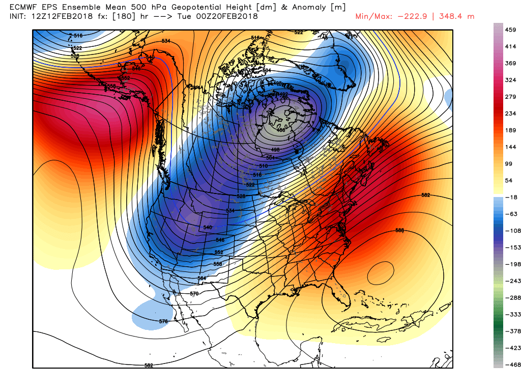
The same pattern looks to almost certainly continue through this weekend as the southerly flow increases once more on Friday ahead of a large area of disorganized energy out over the Plains . A more moderate rain event may be in the cards starting on Friday as more Gulf moisture becomes available over the South. A cold front behind this system looks to temporarily cool things down a bit late in the day on Friday, but Saturday looks to still be a slightly above normal day across the East as mid level ridging starts to buil over the Plains once more. This area of ridging looks to strengthen quite a bit over the east on Sunday, allowing high pressure to get pushed off of the east coast and provide strong southerly flow once more for the entire area. This looks to set the stage for an even larger warm-up next week as some models are depicting a very deep trough to set up in the west, which would be strongly supportive of much above average temperatures lasting through the week next week. In fact, this afternoons European model had many locations across the Northeast well into the 70’s by next Thursday! This can very easily change over the next couple of days, but we will continue to monitor this period of prolonged above normal temperatures!

This afternoons European ensembles showing a very warm pattern shaping up in the medium range across the East
Have a great night!
Steven Copertino

