-2")
Another significant Northeast winter storm expected on Wednesday
On the heels of a powerful Nor’Easter, which delivered widespread heavy rain, winter weather, winds, and coastal flooding, another significant storm system is expected to develop this week. This active, wintry pattern has been expected to develop for quite some time (more than three weeks, actually) but its arrival always comes with a bit of surprise, when it becomes truly clear how active and wintry these patterns can be.
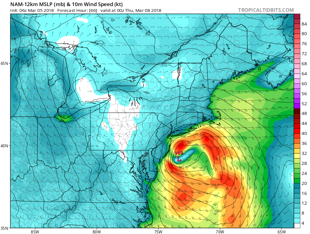
Forecast models have trended toward a stronger and more impactful storm system developing during the middle part of the week ahead, as an incoming atmospheric disturbance interacts with a frontal zone and temperature gradient that sits offshore. A low pressure system is expected to rapidly develop off the Mid-Atlantic Coast, shifting northward towards New Jersey and then moving Southeast of Long Island.
The low pressure system itself is expected to become quite strong rather quickly, but the breadth and intensity of the system will pale in comparison to the storm this past weekend in regards to coastal flooding and wind. That doesn’t make this storm any less significant, however, as its regional impacts will still be notable. Its compact nature suggests heavy, wet snow and winds with an onshore coastal flow in parts of NJ and NY as it develops.
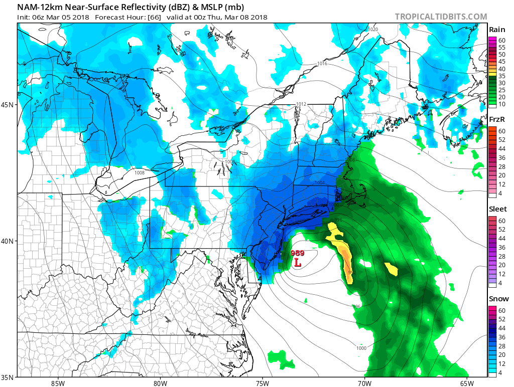
NAM model showing a strong low causing some gusty onshore winds, along coastal sections Wednesday evening
The synoptic setup for the storms development is quite unique. An upper level trough will already have matured over the Midwest States this week and begin tracking east. Under normal circumstances, this would be a fairly harmless atmospheric setup for many – as a low pressure system would develop in the Great Lakes and shift into New England. But, as we have mentioned several times, we are currently in the midst of a period of historically strong high latitude blocking (the NAO recently reached -5 standard deviations). The ridging near Greenland and Eastern Canada will force the storm to redevelop off the East Coast.
As the low pressure strengthens, its track will become critical. Many forecast models (the NAM, GFS, RGEM, etc) suggest it will tuck in close to the coast as it strengthens, sending intense bands of heavy snow into NJ, NYC, PA, LI and CT. A few other models (most notably the ECMWF) suggest it stays slightly further offshore, keeping the heavy snow bands on Long Island and in Eastern New England. We will have to closely monitor these potential track alterations today.
Where the bands of heavy snow set up – expect significant wintry weather. Forecast models suggest extremely impressive upward vertical motion and omega through the dendritic growth zone – fancy words for extremely strong lift for precipitation to form. Heavy, wet snow profiles with a saturated atmospheric column suggest large dendrites and the potential for near whiteout conditions where the bands set up. Within this bands, the potential exists for 8-12″of snowfall, while outside of the bands, or areas where the bands traverse quickly, snowfall numbers will likely be closer to 3-6″.
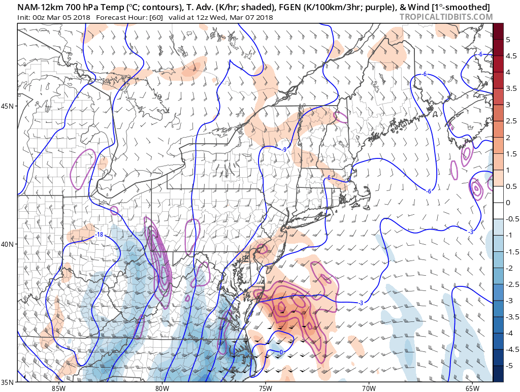
NAM model showing strong mid-level frontogenesis over Eastern PA/NY, New Jersey and New England, resulting in more lift/omega in the dendritic growth zone, for moderate to heavy bands of snow on Wednesday
Confidence is currently highest that these bands will set up just to the northwest of the major cities from Philadelphia to Boston, setting a band of heavy snow up from Eastern PA into Northern NJ, SE NY and CT. But as mentioned earlier, some uncertainties do still exist in regards to the track – and a slight eastward adjustment would obviously change the location of the bands of very heavy snow.
Stay tuned over the next 12-24 hours as we pin down our final ideas in regards to how the storm system will evolve. Another system of significance appears to be right on its heels for the weekend ahead. Buckle up!