-2")
Another significant Nor’Easter develops through Tuesday
[soundcloud url=”https://api.soundcloud.com/tracks/412190928″ params=”color=#d0e3ef&auto_play=false&hide_related=false&show_comments=true&show_user=true&show_reposts=false&show_teaser=true” width=”100%” height=”166″ iframe=”true” /]
Quick Links: Northeast US Impact Map | Snowfall Forecast Map
Good morning, we hope you had a great weekend! You can listen to our audio weather briefing from Sunday evening above.
Sunday was the winner of the weekend weather, with limited clouds and plenty of sunshine underneath a calm and cold high pressure. Despite the cold air overhead, you probably noticed the warm sun – which is becoming increasingly apparent this time of year. We are quickly approaching Spring, after all. The overall weather pattern simply isn’t cooperating just yet.
After two huge Nor’Easters over the past two weeks, we’re expecting our third on Monday and Tuesday. Another powerful cyclone will develop off the coast (beautiful satellite imagery is coming your way!) and bring widespread impacts, this time focused on New England. New York City proper looks to escape the worst impacts of the storm system, as we have been detailing for several days now. But parts of Long Island, Connecticut and Southern New England are likely to experience impacts of more significance.
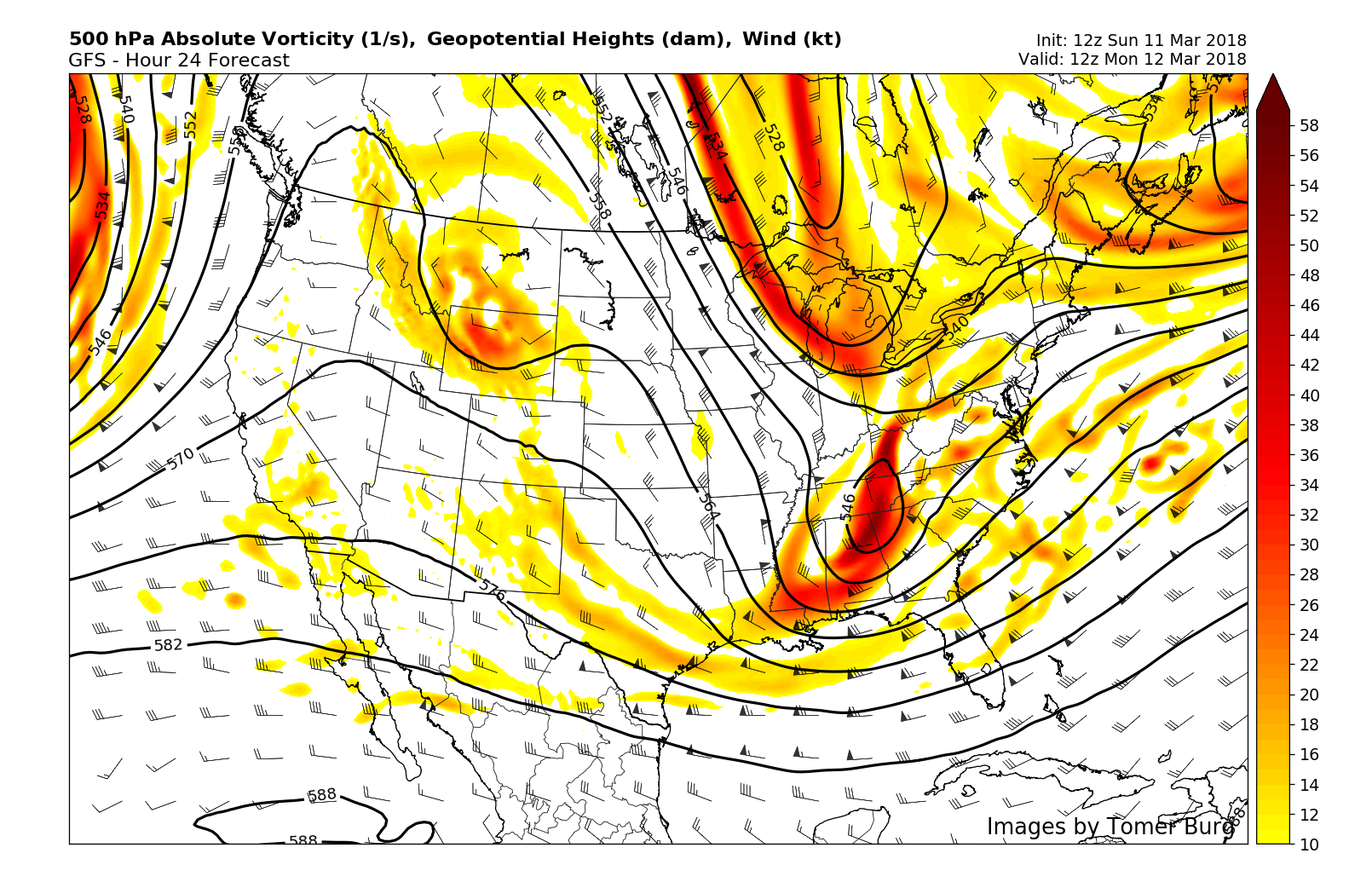
Two disturbances will attempt to phase and form another Nor’Easter. One over the Great Lakes, another over the Southeast.
The same atmospheric pieces we discussed on Saturday are still at play. Two disturbances are likely to phase over the East Coast on Monday, and their interaction will be the impetus for the development of a powerful storm system. It’s an extremely intricate interaction – and forecast models are, not surprisingly, struggling. The most difficult thing here for meteorologists isn’t pinpointing the storms banding or snowfall totals. It’s actually pinpointing where the storm will track – because models are struggling so immensely.
Think of it this way: The process of the two disturbances phasing that ultimately leads to the storm systems development is so intricate that forecast models are either showing everything or nothing at all. Either a powerful storm will develop on Monday evening into Tuesday with significant impacts to New England, or a much weaker, less powerful and less impactful system will form. It comes down to the intricate “phase” of the two features we have been discussing, and it creates a massive headache for meteorologists.
At this point, though, we’re comfortable hedging our bets on the fact that the storm will develop, and do so far enough west to bring significant impacts to parts of Central and Eastern Long Island, and especially Eastern New England. We expect significant snowfall in Eastern Long Island, Eastern New England (Areas such as Rhode Island, Boston, and Cape Cod) with strong winds as well as the storm system develops and strengthens off the coast. The impacts will be much more tame in areas like New York City, on the fringes of any banding.
Monday Evening
As the storm system develops on Monday evening, the low pressure center will still be located over the Mid Atlantic coast. However, moisture associated with the developing storm will slide northward along a frontal boundary, enhanced by an upper level jet streak. Fancy talk for the fact that snow will begin across parts of NJ and LI, possibly even in NYC. It is expected to be relatively light in nature. With that being said, cold temperatures overnight could lead to light accumulations on area roadways. This will be especially true over Eastern NJ and Long Island overnight.
Tuesday Morning
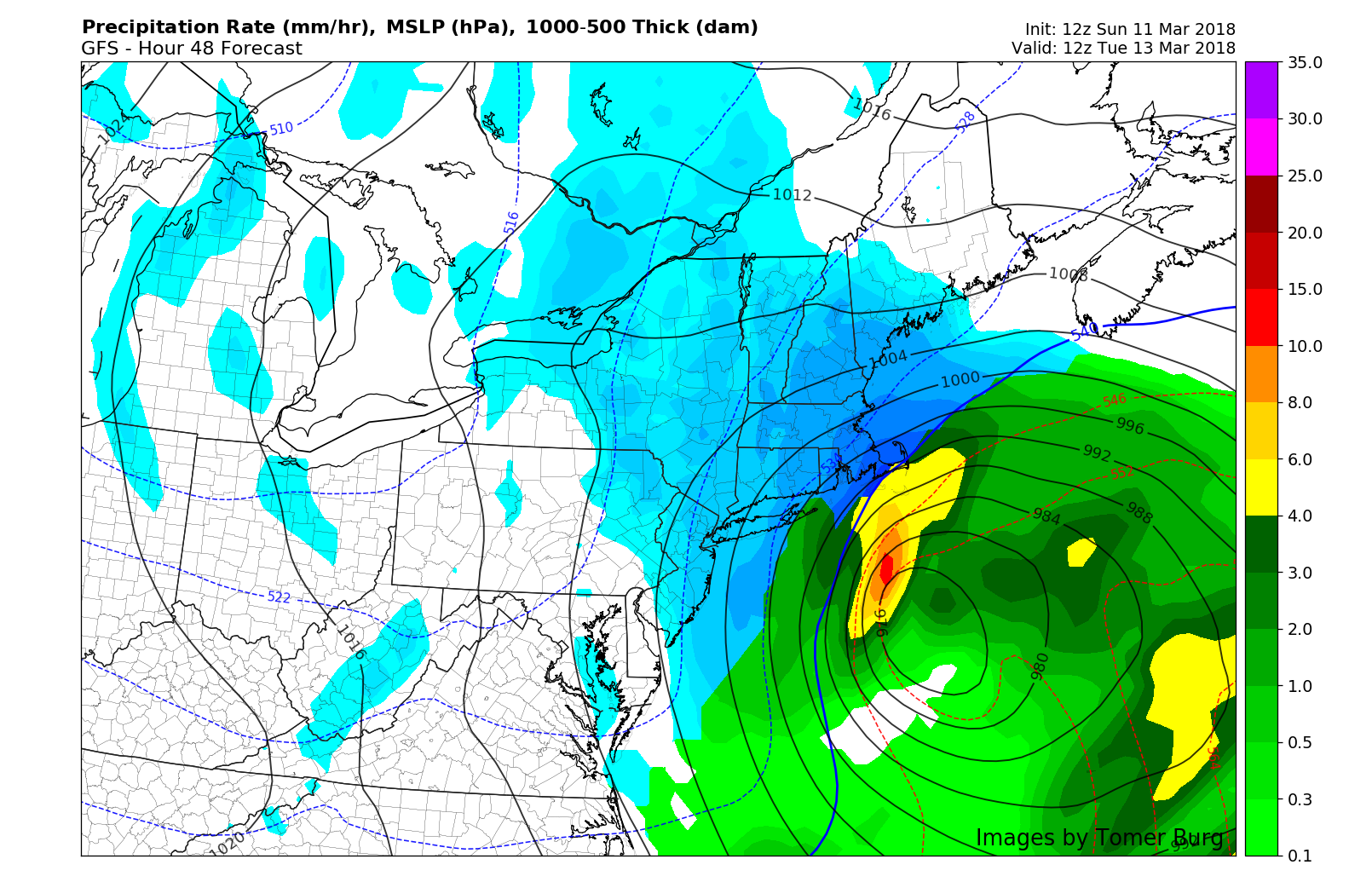
Simulated precipitation type on the GFS model valid Tuesday AM.
Bands of snow will remain quite light over New York City and New Jersey. The focus during this time period will begin to turn toward Long Island, where bands of moderate to occasionally heavy snow will fall, especially in Central and Eastern parts of Long Island. These bands will shift northward into Connecticut and spread through Southern New England as well. Areas further west, like New York City and New Jersey, will continue to see light snow, possibly moderate at times, but accumulations will remain light.
We recommend leaving extra time for travel on Tuesday morning regardless of your location, but especially if you live on Long Island or in Central and Eastern Connecticut and Southern New England. If you live in Eastern New England, just don’t travel on Tuesday at all.
Tuesday Evening
Precipitation will begin wrapping up from west to east, with any snow over NJ and NYC ending. Long Island will see the back edge of banding from the storm system continuing into the evening hours on Tuesday. Meanwhile, the system will hit its stride in New England, with very heavy snow bands pivoting through Eastern Connecticut, Rhode Island, Massachusetts, New Hampshire and Coastal Maine. Strong winds and waves will lead to a myriad of impacts in those areas, including (obviously) wind damage and the potential for coastal flooding. The system itself will slow, but linger into Tuesday Night in those areas before wrapping up and exiting by Wednesday morning.
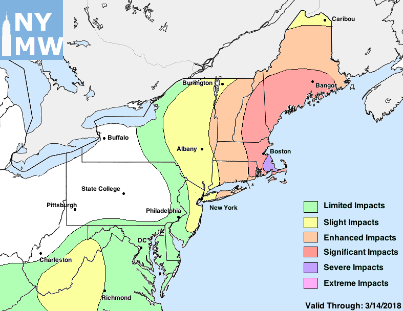
Our latest impact map for the upcoming storm system.
Accumulations and Impacts
Our accumulation and impact map is included below. We hedged towards a further west solution, but not one that includes any significant impacts for NYC proper. Impacts will be much less once one travels west of there into NJ. Central and Eastern Long Island are likely to receive a borderline-plowable snowfall, while areas in Connecticut and Southern New England are in for a significant winter storm.
The storms maximum impact will come in Southeast Massachusetts, where heavy wet snow and strong wind gusts will combine to lead to “Severe” impacts, which we characterize as severely impactful and/or unusual weather that will cause a significant disruption to daily life including widespread travel impacts and the potential for property damage. Our snowfall forecast for the local NYC area is included below as well.
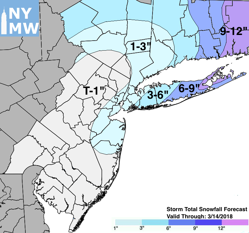
Our Storm Total Snowfall Forecast through Wednesday.