-2")
NYC Area Forecast: Calm weekend, another storm threat looms
Snow squalls and blustery winds have been the tale of the tape here for the past 24 hours as a cold and wintry pattern remains stagnant in the Northeast States. Much of this can be attributed to the powerful Nor’Easter that impacted the region just a few days ago, as it tracked northward and pulled in unseasonably cold air. This will continue for one more day, with snow squalls likely throughout the Northeast states again on Thursday.
Some temporary good news then comes to light as the weekend is expected to be rather quaint. Temperatures will warm up a bit each day as the airmass begins to modify to its surroundings (without a true cold air source anymore) leading to more pleasant and comfortable weather, although temperatures in the Northeast states will still be several degrees below seasonal averages. The lack of storms will certainly be a welcomed addition to the weekend – but it won’t last for long.
Before we can even really settle into the week ahead, forecast models and ensembles are already giving us hints that another potential storm may be on the horizon. Another Greenland block will dislodge cold air further south over Southeastern Canada, and a disturbance originating from the Pacific Ocean will track into the Tennessee Valley by Monday and Tuesday. Ensembles vaguely suggest that a low pressure system will emerge and track into the Mid-Atlantic, then redeveloping off the East Coast.
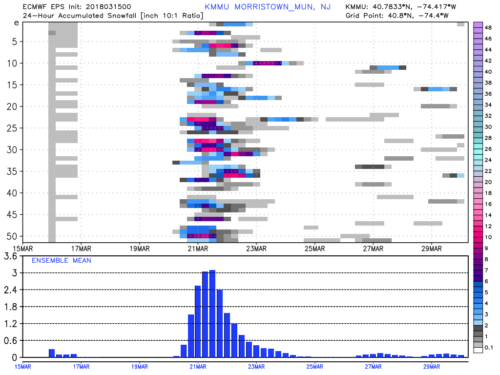
ECMWF ensembles members showing moderate to significant snowfall for Morristown, NJ mostly Tuesday and Wednesday 3/21-23
Exactly how the storm evolves, though, remains extremely uncertain. There are actually two distinct disturbances tracking to the south of the Northeast States, and models are “stuck” a bit as they try to resolve which, if either, will become dominant. This obviously leads to a large amount of uncertainty from a forecasting perspective moving forward as individual solutions don’t offer much help into possibilities of what may actually occur.
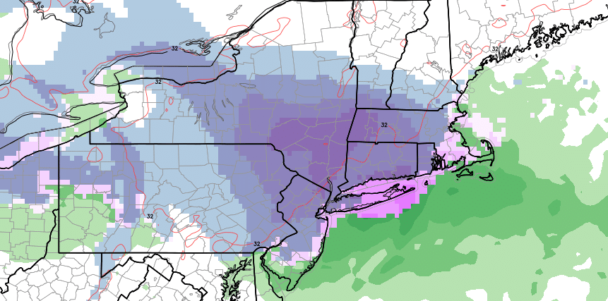
With that said, we can utilize ensembles as a tool to visualize where clustering is occurring and what potential periods to focus on. In this case, the ECMWF EPS are solidly focused on Tuesday and Wednesday of next week for the potential for a winter weather event in the Northeast. 24 hour snowfall probabilities show us very clearly where the potential event lies – and snowfall amounts range from very little to quite a lot (significant snow).
Over the next few days, our job as meteorologists will be to hone in on the details of the evolution of disturbances aloft and try to discern how the storm system(s) will evolve during the early part of next week. While the threat exists for another winter storm, the potential remains convoluted and the possibility of nothing at all (or rain) still exists. So, as the saying goes “stay tuned” for further details as we work to grind through the details of what the atmosphere is really doing over the next several days.
Trackbacks & Pingbacks
2proffer
Comments are closed.