-2")
NYC Area Forecast: Nicer weekend, winter storm possible next week
Friday began with a bit of a different tune than the past few days – although it’s cold this morning, it is not quite as blustery and the risk of snow squalls has been reduced. In other words, the air feels a bit less “wintry”, as the airmass itself begins to modify a bit to its surroundings. It’s still quite cold though and honestly, several degrees below average for this time of year, and you can feel it throughout the majority of the Northeast states today.
The weather over this weekend will remain much colder than average for this time of year. Temperatures are forecast by the European model to run several degrees below normal on both Saturday and Sunday throughout the Northeast states, as arctic high pressure redevelops and aids in funneling cold air southward from Canada. This secondary surge of cold air is being driven by the redevelopment of a Greenland Block, which by this point has become a thorn in the side of many, as it has been the impetus for this late season winter weather surge. Low temperatures tonight throughout a large part of the area will fall down into the mid to upper 20’s and may even reach the teens in some suburbs.
Winter will have the last word once again next week. As the Greenland Block strengthens once more, it will aid in the development of a cold, confluent flow over Southeastern Canada. In other words, a deep surface high pressure will move from Central to Eastern Canada. This will funnel low level cold into New England and the Northeast States. Back to the southwest, multiple mid level atmospheric disturbances are forecast to develop. These will slide eastward towards the Coastal Plain, eventually interacting with an airmass that is unusually cold for this time of year.
The signals for a winter weather event are all there.
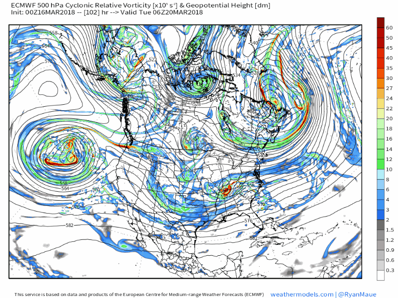
European model showing the upper level evolution of the storm system next week with a deep trough in the Eastern US.
Forecast models, as you may imagine, continues to struggle with exactly how the system will evolve. A primary low pressure system is initially forecast to move northward into the Tennessee Valley from Monday into Tuesday, spreading precipitation northward into the Mid Atlantic and eventually Northeast states. Then, gradually, a coastal low pressure is expected to form offshore and aid in additional precipitation forming near the coast.
One of the main questions remaining is the strength of high pressure to our north and the mid level atmospheric evolution – how far north will precipitation come as a result of the surface low pressure track? The ECMWF, for example, keeps meaningful precipitation further south over the Mid Atlantic, with a significant snowstorm for Washington, DC and parts of Philadelphia with much less for New York City. Other models favor a further north track with significant snowfall over all of New England.
One tool we can use, as we move through the next friends, is analog guidance. CIPS Analogs provides a valuable tool where we can analyze forecast model projections and take the top analogs from them – essentially similar events that occurred in the past. Utilizing this package, we can get an extended look at potential hazards and details of how synoptics evolved with similar events in the past. It’s important to remember that these are based off forecast models, so have to be taken with the caution that they are based on that model being correct.
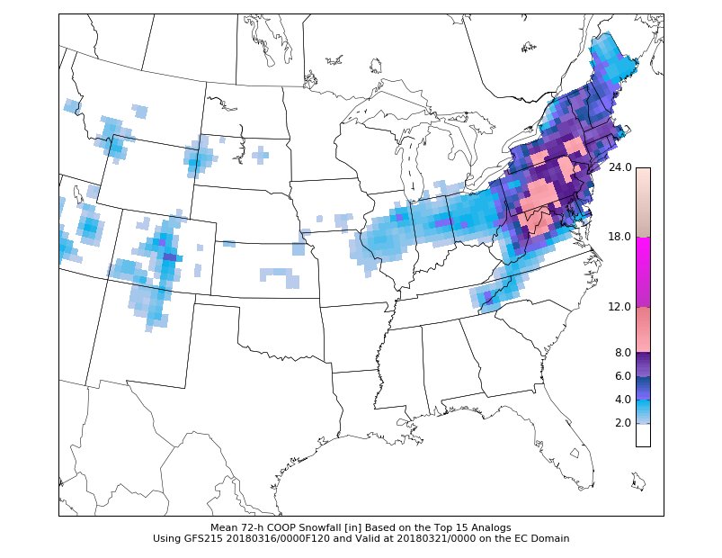
CIPS Analogs based on the 12z GFS showing significant winter weather potential next week.
The Top-15 analogs based on the evening GFS are quite impressive in terms of winter weather impacts across the Northeast States, featuring some big time snowfall events (2/6/2010 in the Mid Atlantic is included). As pictured, the mean snowfall is significant across a large swath of region. It’s important not to get too caught up in numbers, but instead pay attention to the overall “signal” which matches what we are seeing evolve on forecast models.
So, what’s next? In the next 24-48 hours, our meteorologists will continue to analyze the synoptic scale evolution of the storm. Where is the best lift tracking, and how are forecast models handling it? Will the storm system track far enough north to impact New England? How are ensembles trending with the evolution of the storm? As we begin to answer these questions and formulate a picture of how things are evolving, we can start to discuss details of potential impacts as we move through the weekend.
For now, enjoy a beautiful Friday!