-2")
NYC Area Forecast: Another winter storm possible this week
Good morning on this cool and wintry Monday. After a calm and benign weather weekend in the Northeast states, our full attention has turned to the potential for a winter weather event during the middle of the week ahead. This potential event has been spoken about for quite some time now, and the evolution has changed on forecast model guidance quite a bit over the last 48-60 hours. With all of that said, the potential for a storm of significance still exists.
The week is expected to start off quietly on both Monday and most of Tuesday. Transient clouds and very cold temperatures are expected. There’s no shorting this airmass – it’s extremely cold for this time of year, with temperatures several degrees below average for several days in a row. Temperature departures will exceed -10 F in many locations during this time frame. As our cold continues, a disturbance is organizing in the Central Plains and beginning its move eastward, setting the stage for a complex and convoluted storm evolution during the middle part of the week.
Okay, so what’s going on? How is the threat evolving?
As has been the case for the past few weeks, high latitude blocking (or ridges of high pressure in the higher latitudes) will guide the threat. Ridging near Greenland has forced colder air southward into Southeast Canada and New England. Meanwhile, disturbances are being forced to eject southward and “underneath” this block, into the Tennessee Valley and Mid-Atlantic states. This fosters an environment that encourages the development of low pressure systems near and off the East Coast.
This storm’s evolution, in particular, is quite convoluted. There are two distinct “areas” that are associated with the disturbance. First, a shortwave ejects northeastward towards the Mid-Atlantic states on Tuesday. It dampens out and eventually becomes an area of enhanced lift for precipitation. This will drive an area of moderate to heavy precipitation northward toward Washington,D.C, Philadelphia, and New Jersey on Tuesday.
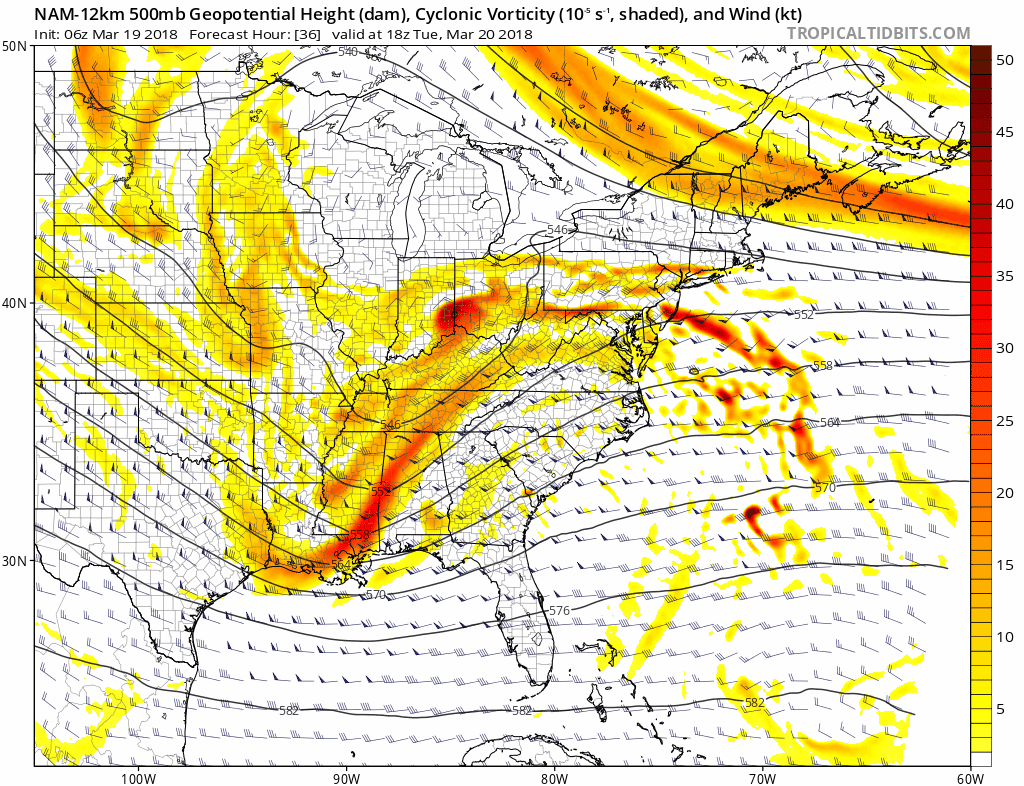
NAM model showing the powerful upper level evolution that could lead to a major winter storm mid week.
Back to the west, however, intense height falls (or the development of a trough) are forecast to occur underneath the blocking ridge to our north, as disturbances phase and eject towards the Southeast US Coast. This promotes the development of larger trough with more powerful dynamics, and the potential for the development of a strong low pressure system off the East Coast. Forecast models have struggled mightily with exactly how this phasing will occur, how intense the trough development and vorticity development will be, and (Accordingly) where the low pressure will track.
Some forecast model guidance suggests yet another powerful coastal storm moving northward towards the Mid Atlantic and Northeast US shores, while others suggest just enough interference between disturbances that the trough remains progressive and stays east, with the surface low forming further out to sea and the impacts remaining more negligible in the Northeast States.
What solution is favored at this time?
From a forecasting perspective, this is a very difficult situation. To give you a peek into the world of a meteorologist – now is the critical time where we need to begin communicating sensible weather impacts, travel delays, etc to local emergency management and other businesses and government officials. However, forecast model guidance is still in the process of “trending” or figuring out the intricate details of the storm systems evolution. The guidance isn’t offering much insight as to how the storm system should directly evolve. We don’t even have agreement on the storm systems track, let alone details of impacts.
This puts us in a situation where many meteorologists will choose to defer. Pass the potato. Skip. In other words, you’ll hear “we just don’t know right now” or “we’re waiting for more information”. What’ we’ll choose to do, instead, is use the model guidance as exactly that – guidance – to back up our ideas of how the atmosphere is evolving. When we look at the overall synoptic evolution of the weather pattern, we are comfortable forecasting impacts from this storm system essentially from Washington, D.C to New Jersey and including parts of Long Island and Southern New England – despite what forecast models have to say.
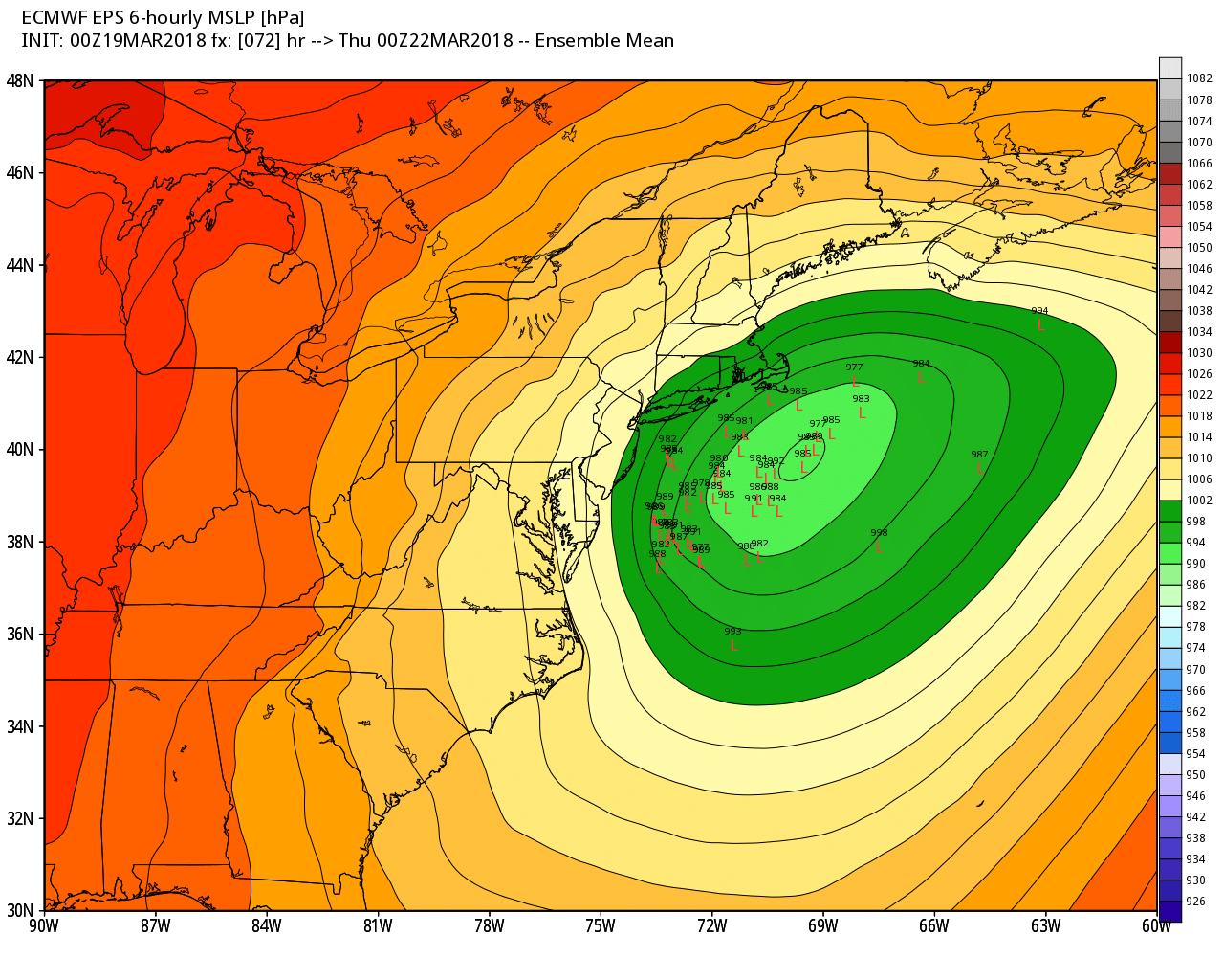
ECMWF Ensemble showing many members tracking the storm very close to the coast on Wednesday.
We expect winter weather impacts to evolve across the below highlighted areas from essentially late Tuesday through Thursday. The “larger” storm system remains a wild card, and these impacts may have to be either raised or lowered as that storm systems development becomes more clear. We don’t currently have enough confidence to forecast some of the “huge” solutions (a rapidly strengthening low pressure system right near the NJ Shore) based on our synoptic evolution of the pattern – but it remains well within the window of possibility.
Our impact map that is attached features a few key impact regions. While the map is still in development, its main point is to simply the maps and alerts that you see all over the internet. In other words, we’re trying to make it easy to understand what you should expect. The impacts range from “Limited” (very little impact on your day/operations) to “Severe” (unusual, anomalous, or highly impactful weather that may impact property) and “Extreme”. We hope these maps offer an improved visual as to how we expect the storm to evolve.
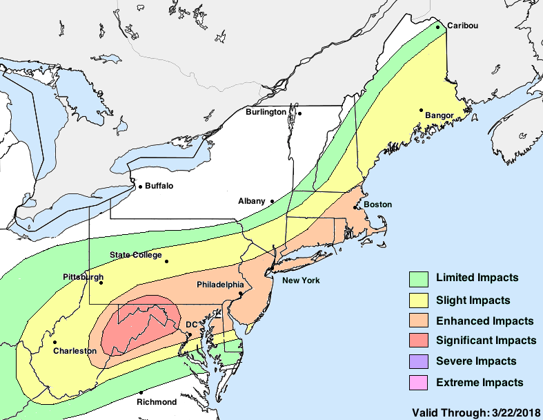
Impact Map for the evolving storm system from Tuesday through Thursday.
Tl;dr and what’s still to come…
- We’re expecting a significant winter storm this week across the Mid-Atlantic and Northeast, essentially from Tuesday through Thursday
- A first “Wave” impacts the Mid-Atlantic on Tuesday, and a second enhances precipitation that shifts further north through Thursday.
- The second “Wave” is extremely uncertain, but we hedged towards a slightly more impactful solution in this forecast package (see impact map)
- A closer to the coast/stronger track with the larger second storm could bring widespread significant impacts, while a weaker or seaward track would limit impacts.
As we continue to hone in on the development of the storm system, we’ll be publishing our thoughts later today in regards to the storm systems timing, impacts in local areas of the Northeast, and potential snowfall accumulations.