-2")
Update: Significant winter storm expected through Thursday
Quick Link: Storm Total Snowfall Forecast
Good morning!
There has been a rather substantial shift over the past 24 hours with regards to the potential waves of wintry weather that could impact portions of the Mid Atlantic and Northeast Tuesday through Wednesday night. Back on Friday, we highlighted the potential outcomes for this system as a whole, with the first option being that the system remains weak and the blocking (confluence) to the north remains too strong. For the entire weekend, the model guidance showed that this was likely going to be the outcome, with the bulk of the precipitation staying south of the Mason Dixon line. However, over the past few days, the model guidance had shifted towards a much more impactful solution, with several of our more reliable models even bringing significant precipitation into the vicinity of the New York City area.
————————————-
First Wave (Tuesday into Tuesday Afternoon)
A mid level system currently over the Ohio Valley is the beginning of the winter storm potential over the next few days. As this mid level low moves to the north and east, it should gradually weaken and “shear” itself out due to a strong upper level jet and strong confluence just to its north. However, this wave will likely not die-off quietly. Warm/moist air at the surface and in the mid levels will begin to stream northward into the cold air in place over the Mid Atlantic and Northeast. This setup will create “ascent”, or lift in the atmosphere due to the warm air rising over the more-dense cold air at the surface. This will cause precipitation to remain steady or even strengthen a little as it approaches portions of Maryland, Pennsylvania, and southern New Jersey later this morning and into this afternoon. By this time, surface low pressure will be located over portions of North Carolina, with winds likely coming in off the Atlantic for the vast majority of coastal locations. Onshore winds, in addition to daytime heating will make initial precipitation types very complicated over the Mid Atlantic and Northeast. As of this time, it appears that the dominant precip type will be snow for the morning hours over the Mid Atlantic, but a gradual mix towards sleet and rain will be possible, especially the further south you travel.
Closer to the NYC area, strong lift should gradually move north during the afternoon, likely creating a moderate to heavy band of snow over portions of southern and central New Jersey . Depending on how far north this band can travel, at least moderate snow is expected to move into the NYC metro area this evening. However, very dry air will continue to eat away at the northern edge of precipitation. A mix of sleet and rain will also be possible across the area due to peak daytime heating and the Spring sun-angle working against the marginal airmass in place.
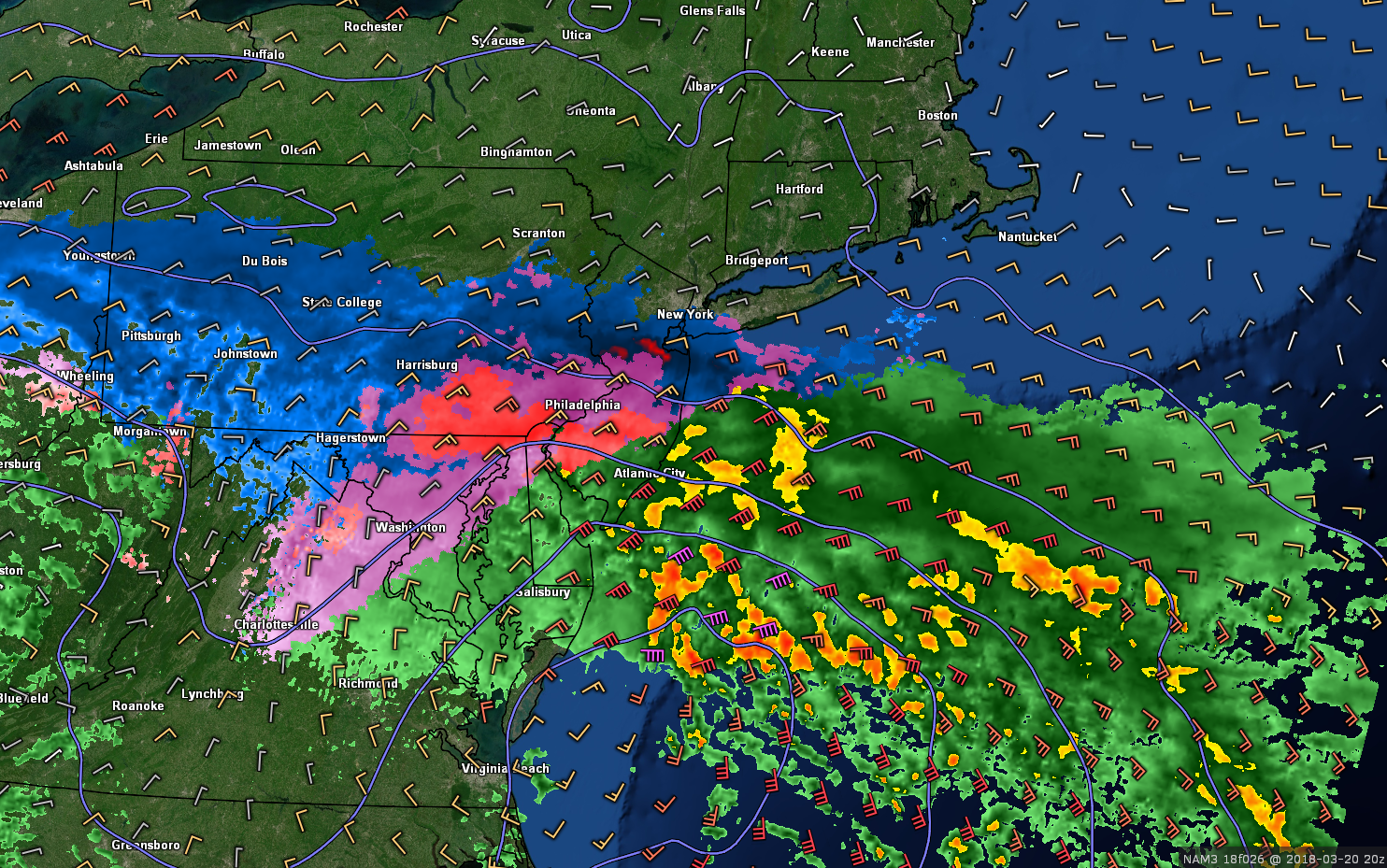
This afternoons high resolution NAM showing heavy snow, sleet, and rain over portions of the Mid Atlantic and Northeast Tuesday afternoon
Second Wave (Tuesday Night into Wednesday Afternoon)
A second and more complex evolution will likely take place from this evening into Wednesday, as energy from Canada and the Southwest US falls into the base of the lingering trough over the East and begin to interact with one another. Over the past day or so, the models have begun to show this second wave becoming more organized in addition to the confluence to the north slowly backing away, after the first wave “bumps” into it. As all of this energy begins to consolidate and strengthen over the south, and a second surface low should develop off of the Mid Atlantic tomorrow night in response to this. The development of another surface low will likely sustain light to moderate precipitation over the Mid Atlantic and Northeast, causing additional light to moderate wintry accumulations.
The latest model indicated that the mid/upper level trough will mature in such a manner that it will be capable of throwing enough energy towards the developing surface low pressure off the Mid Atlantic coast. Such an evolution could cause the low to becomes trapped and force it to basically stall while maturing. As this low stalls, the synoptic setup would allow for an impressive upper level jet streak to develop over the Northeast, and with the surface low steadily deepening and the upper level jet streak fanning out developing precipitation, we could see the development of a rather large precipitation field over the Northeast by Wednesday morning and into the afternoon. The models continue to focus on the bulk of “Wave 2” taking place from 11am Wednesday and through 8pm Wednesday. Such a solution as the one above would be much more supportive of significant snow for a large portion of the Northeast, as dynamic cooling and colder surface temperatures rush towards the center of the low pressure.
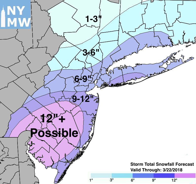
Storm Total Snowfall Forecast through Thursday.
As mentioned, there are still many moving parts to this forecast, with significant changes in either direction possible over the next 12hours. We will continue to hone in many of the developing aspects of the forecast and fine tune many aspects of the anticipated impacts.
Later this afternoon, we will provide a breakdown in timing and a final version of the Storm Total Snowfall Forecast.