-2")
Significant winter storm begins, widespread impacts likely
3:00pm Update: The winter storm is continuing to come together across the Northern Mid Atlantic. Snowfall rates have increased area-wide and will continue to become more steady, as banding in the storm system develops. The dynamic aspect of the system is still ongoing, transferring the coastal low that will become dominant. As this occurs, bands of heavier snow should pivot inland towards NJ, NYC, and Long Island.
So far, around 4.5″ of snow has fallen at Central Park, and a similar amount at Newark. Some areas are observing local differences, which is typical. But with heavier/steadier snow rates continuing and sunset approaching, we expect accumulations to become more widespread, even on roadways throughout the region. The latest radar shows the bands well, especially over Northern NJ and NYC over the past 30 minutes.
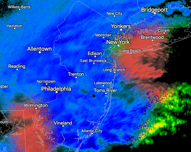
Radar as of 3:00pm on Wednesday.
In addition to the heavy snow, winds will increase, with strong northeast wind gusts possible as the storm hits its stride. Along the coast, east/northeasterly winds will encourage the potential for coastal flooding, especially in prone areas, but exacerbated by high tides, especially along the Central and Northeast New Jersey Shore. Again, the main point to drive home this afternoon is that we expect bands of snow to continue to pick up in intensity during the mid to late afternoon and early evening hours.
Wednesday Evening
Bands of moderate to heavy snow will continue, specifically across much of New Jersey, Eastern Pennsylvania and Long Island as a cold conveyor belt develops and enhances precipitation rates. Snow will continue to accumulate during this time frame, with significant accumulations having already occurred. Bands will slowly begin to pivot eastward during the overnight hours, with the storm coming to a very slow end over the mentioned areas, but continuing across Long Island and Southern New England into the overnight and early morning hours of Thursday.
Travel during the evening and overnight period into Thursday morning will remain extremely difficult and is not recommended, with significant snowfall on roadways and strong winds continuing with blowing snow possible.
Summary of Impacts, Details and Uncertainties
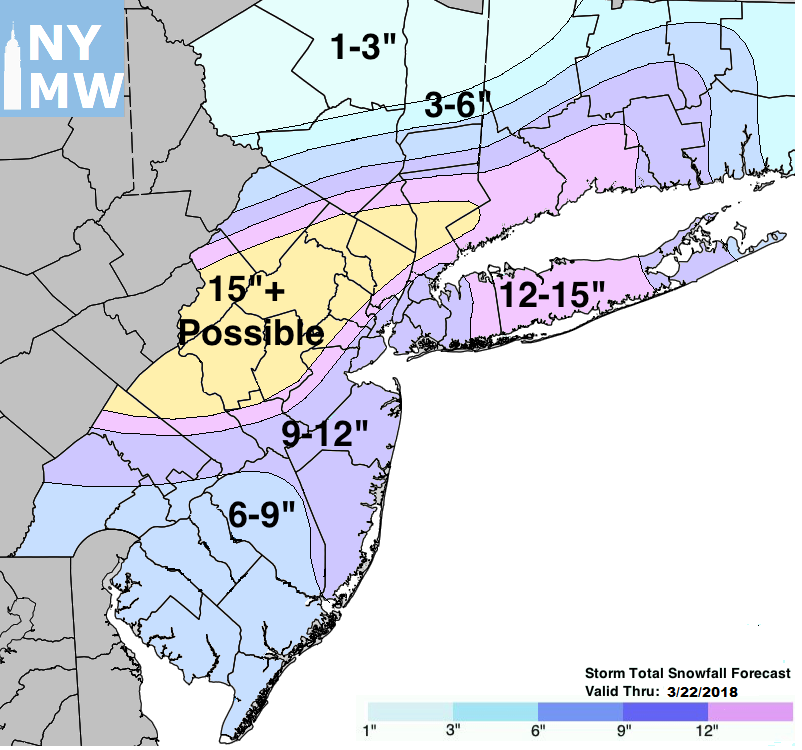
Storm Total Snowfall Forecast through Thursday
This will not be a typical March Nor’Easter. A very cold, winter-like airmass is in place and a strong Nor’Easter is forecast to develop – leading to widespread impacts from significant winter weather. The storm system’s impacts are expected to be widespread and spanning all of Wednesday, continuing essentially into Thursday morning. Travel impacts are expected to be widespread and severe. We do not recommend traveling unless it is an emergency from Wednesday afternoon into Wednesday evening. If you have travel pre-planned, check with your carrier, as widespread delays and cancellations are already occurring and are expected to continue.
The main uncertainty that continues is the northern fringe or edge of the heavy snowfall amounts. The ECMWF and ECMWF Ensemble are much further south than other models, which brings some uncertainty into the forecast. Just a slight south trend in the storms evolution could lead to much lesser impacts across Northern New Jersey, New York City, Connecticut and Long Island. We will continue to closely monitor the evolution of the storm as the evening goes on and into Wednesday morning.