-2")
A Spring Snowstorm in the Northeast? It’s not out of the question
On the morning of March 22nd, many people in the NYC area were digging out from over a foot of snow. Even as the last flakes floated down from the sky, the familiar Spring sound could be heard: Drip. Drip. Drip. The snow was quickly melting, and after a series of four Nor’Easters had impacted the area in March, most of us were thinking that winter was finally over.
We have some bad news.
A good look at the upcoming pattern in April tells us that it is not over and in fact, there is a good chance that we will be tracking snow threats in the first ten days of April.
We understand now that we have to explain ourselves, and we will. Let’s begin by taking a look at the pattern we have experienced so far in March, and then roll forward to what is expected to evolve in April. The main feature that stands out is a large blocking ridge near and just south of Greenland, which locked in a large trough underneath it along the East Coast. These persistent features were the main reasons why so many large storms were forced to slow down and rapidly intensify along the East Coast, and the blocking pattern and trough were able to provide just enough cold for a lot of the area to see major snow.
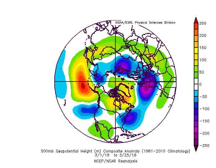
The pattern in March featured a large west-based -NAO block, but not necessarily a Pacific pattern that was conducive for big cold (ESRL/NCEP/NARR).
Looking at the Pacific side of the Northern Hemisphere, we actually observed a pattern that was relatively unfavorable for snow in the East. There was a large ridge in the Northeast Pacific, but it was at a relatively low latitude, and thus did not break into the Arctic regions. This means that Arctic air was not necessarily able to get displaced into Canada, so there was no true, bitter source of cold air for these storms to tap into. And we still managed to get significant snow. What a concept!
In all seriousness, the -NAO blocking pattern in the Atlantic was so strong, that when combined with a retracting Pacific Jet and occasional amplification of ridging near Alaska, we were able to retract the main trough in the Western USA to a position just off of the coast. This also aided in providing the marginal cold that was needed for snowstorms, as we can see that there was some ridging downstream of that trough in the Southern Plains and in Central Canada. Essentially, some cold air was able to slide into the US, downstream of this ridging. Additionally, the -NAO block allowed some small lobes of the polar vortex to trail behind and stall in Southeast Canada, which also provided additional cold, this being especially true in the coldest storm of the series: the March 20-22 snowstorm.
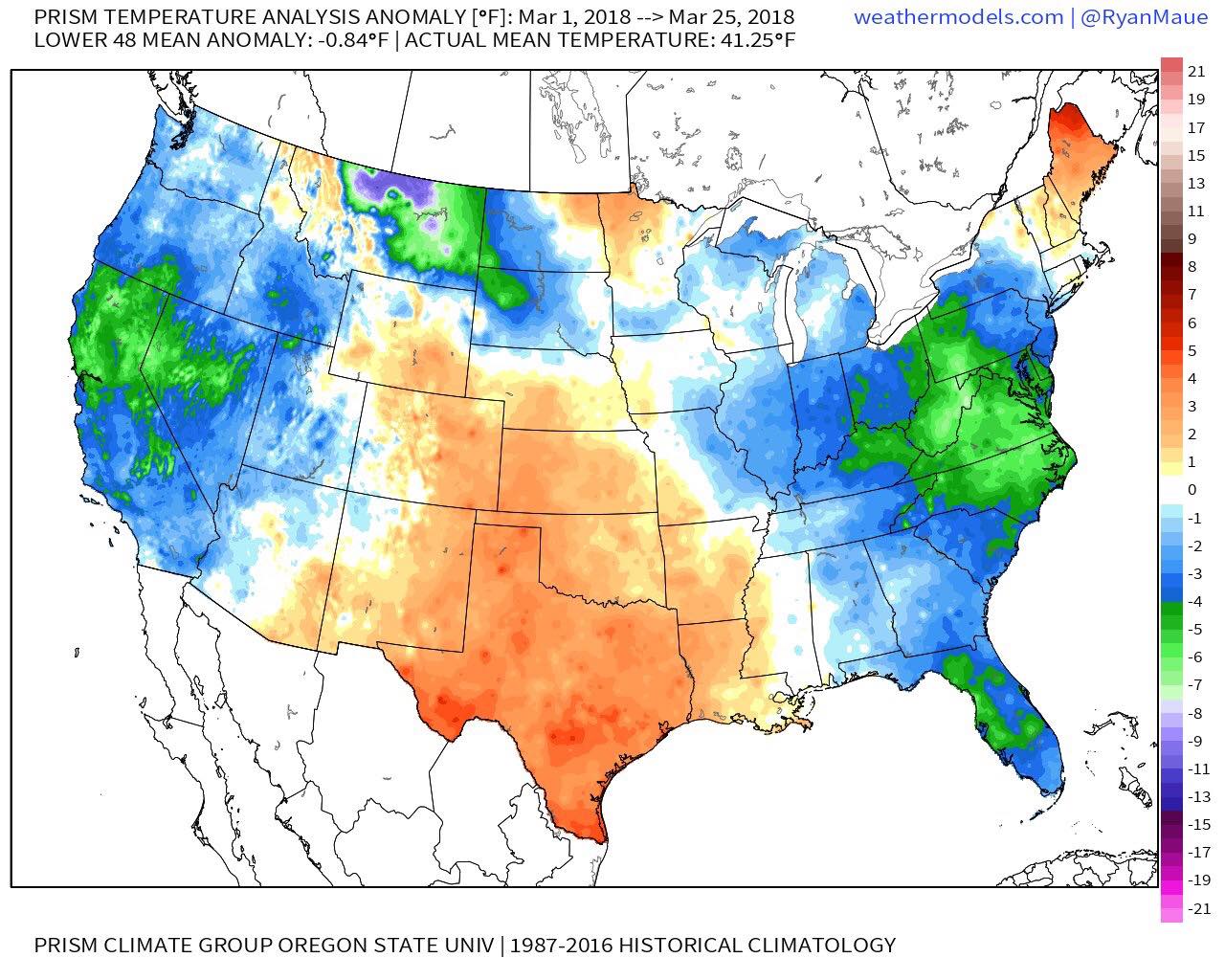
The temperature anomalies for March thus far show the -NAO leading to cold in the Mid Atlantic, but the rest of the US has generally been relatively warm (PRISM Climate Group).
The main point of all of this isn’t to do a March retrospective – it is to suggest that while March certainly had a very favorable pattern for snowstorms, the actual mechanisms for cold generation were not ideal. This is why many meteorologists back in February were skeptical of the snow threats in March for the East; but of course, they significantly underestimated the impact of a strong -NAO block, and how it can easily “make up for” a poor Pacific pattern for snow, or even temporarily turn that Pacific pattern into favorable one for snow.
Most also ignored the fact that the trough in the West would retract off the West Coast, allowing good wave spacing for storms as well, while removing the initial Southeast ridge that many were fixated on. At New York Metro Weather, we look at the scope of the pattern beyond the verbatim model plots so that we can isolate the true signals that matter, which is why it was fairly obvious that the March pattern would deliver snow, and why it’s also apparent that the pattern in April signals snow. Okay, that was a little self back-pat. These things are allowed sometimes, no?
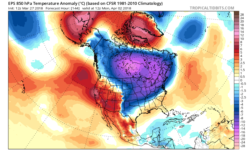
Moving forward into April, the average temperatures become a lot warmer. Thus, if you are looking for it to be cold enough for snow in April, the pattern we observed in March with poor Pacific mechanisms for truly generating cold will not cut it. Well, great news! As we move into April, the Pacific will actually team up with the Atlantic to provide an ideal signal for cold, which is crucial for delivering snow into the Northeast this time of year.
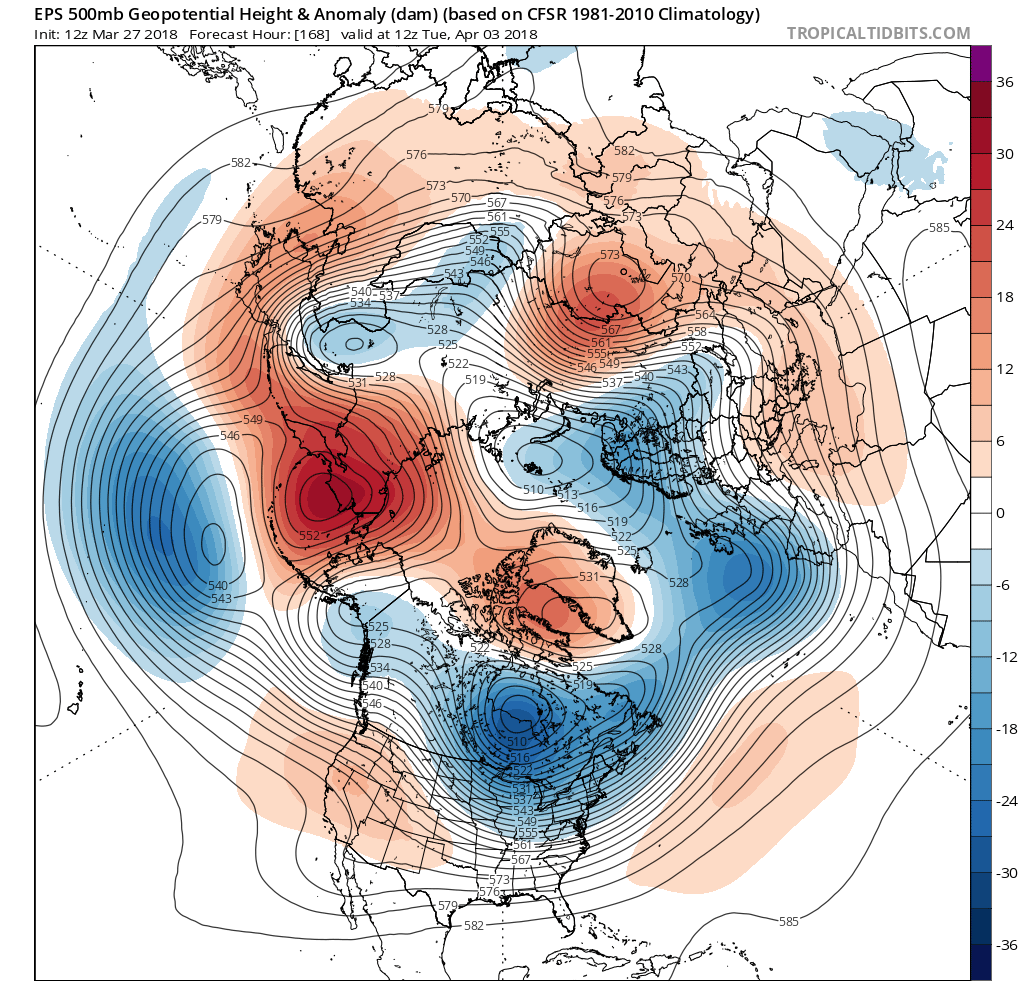
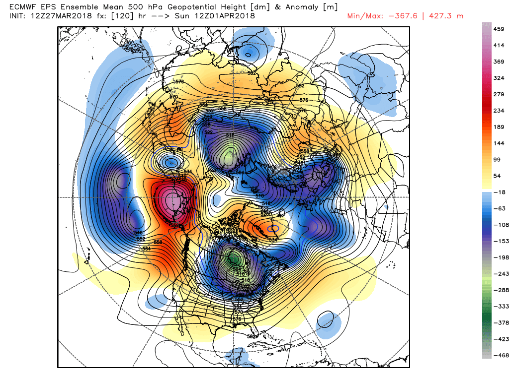
Tuesday’s 12z EPS valid for April 3rd shows an ideal blocking pattern for generating cold and snow (Tropical Tidbits).
The above map shows the EPS (European Ensemble) forecast for April 3rd. It does indeed show another strong -NAO blocking pattern, with a cutoff ridge near Greenland. However, the main difference between this pattern and the one we had in the March is the Pacific Ocean. The forecast pattern shows a very large blocking ridge near the Aleutian Islands, with some of that ridge bending towards the Arctic — a much higher latitude than what we’ve had in March. This is significant because it allows significant cold to get displaced in Canada, and sends a very large and elongated polar vortex into Southeast Canada. Additionally, the -NAO block forces the core of that polar vortex to stay in that general area, which creates a consistent source of significant cold, while also keeping the storm track to our south.
Tuesday’s 12z EPS run below showed some significant snow in a large area of the Northeast, and it’s often more important to look at the progression of the main features, rather than just their verbatim, snapshot locations, as far as gauging a pattern’s evolution towards snow is concerned.
The 7-day progression from days 5 through 11 on Tuesday’s 12z EPS shows a very favorable evolution for snow in the Northeast (Weatherbell).
With the progression as our focus, we decided to take a look at the 7-day progression from the 5-day EPS forecast through the 11-day EPS forecast, as this EPS run showed a large snow signal in the day 10-11 timeframe (around April 6-7). The main features that stood out were the large Pacific block supplying the cold, but then gradually retrogressing and weakening, and the strong -NAO block keeping the elongated polar vortex generally in Southeast Canada, but then gradually weakening — giving us initial cold and suppression but then gradual room for Eastern US trough amplification within that cold airmass.
The -NAO block gradually weakening, but initially being very strong while working in tandem with a strong Aleutian block allows the large, elongated polar vortex to generally progress eastward, and dip into the US. The core of that vortex then makes its closest approach to the Northeast just before the verbatim time period of the snow signal. Additionally, we see some of this lobe retreat into the 50/50 region as the storm is approaching — giving us the classic “50/50 low” signal. We decided to compare this 7-day progression to the 7-day progression that led up to all of NYC’s 6″+ snowstorms in April:
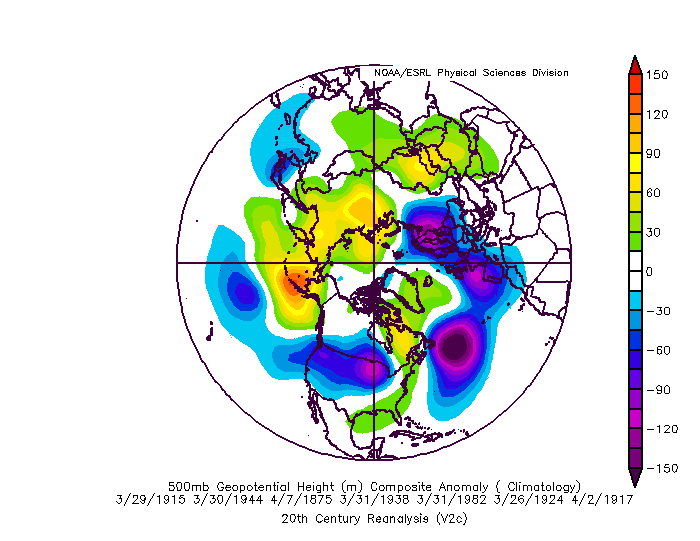
The 7-day pattern progression leading up to NYC’s 6″+ April snowstorms is very similar to the EPS forecast for early April. (ESRL/NCEP/NARR). Cerdit user unclew1 on the 33andrain.com forums for researching when these 6″+ events occurred).
While the pattern advertised in this composite is not exactly the same, they are very similar, especially when looking at it from a progression standpoint, rather than a verbatim match. The important features regarding: 1) The strong Pacific block, its retrogression and weakening, 2) The elongated, eastward moving polar vortex displaced in Southern Canada dipping into the US, and then gradually lifting out to the northeast, with the core of the trough/vortex making its closest approach just before the day of the storms themselves, 3) The -NAO block forming and then gradually weakening, and 4) The Pacific retrogression allowing ridging to form in the Western US — all as the pattern evolution progresses — is essentially an exact match. They both even have the same exact initial Rex Block configuration in the Pacific, with a large upper-level low sitting directly underneath the large Aleutian block!
All of this information tells us that the projected pattern progression for early April, 2018 very closely resembles the pattern progression we had in the past for significant NYC April snows. Thus, the chances of accumulating April snow even down to the coast are much higher than normal. In fact, excluding the time of year, the projected pattern is actually more favorable for snow than the one we had in March, because the Pacific pattern is going to be generating cold much more efficiently than it did in March.
However, things can still change. For one, the EPS progression is merely a forecast, and not necessarily reality just yet. Additionally, the wavelengths in April are generally shorter than they are during the peak of the winter, and thus it’s possible that the wavelengths shorten up a bit. What this would do is keep the consistent core of cold buckled back to our west, allowing the storm track to be a bit too far west for accumulating snow. Furthermore, even significant cold in early April is not always enough to generate accumulating snow down to the coast.
Regardless, however, we anticipate going back into snow tracking mode in only a few days from now. Stay tuned!
For access to our Enterprise products and posts like this one in your inbox frequently, give us a shout HERE.
Trackbacks & Pingbacks
3fujitsu
Comments are closed.