-2")
Beautiful weather today, potential increasing for snow Monday
Happy Saturday!
Saturday should start off nice and clear, but chilly across the Northeast as and area of high pressure takes control of our weather. Conditions should gradually warm up throughout the day tomorrow with clear skies and southerly winds developing. This should allow temperatures to warm back up into the lower to middle 50’s across much of the New York metro area, with middle to upper 50’s likely over portions of the Mid Atlantic. Clear and dry conditions look to persist throughout the entirety of the day, so tomorrow will likely be an excellent day to go outside and enjoy the day! High pressure will continue to gradually move offshore tomorrow evening, but will still supply the region with enough warm air from the south to keep temperatures from dropping too low. Lows should be in the upper 30’s to lower 40’s for the area, with middle 40’s likely over portions of southern New Jersey.
Another frontal system looks to move into the Northeast Sunday, as an upper level disturbance moves quickly across southern Canada, dragging a surface low well to the north of our area. Warm air convection in the mid levels looks to be maximized during the early morning hours of Sunday, with some moisture streaming northward into the area as well. This should lead to clouds developing early in the day, with temperatures rising into the middle to upper 40’s across the eastern half of the Northeast ahead of the cold front. This cold front appears that it will be decaying as it pushes through the NYC area, so any showers that are left over with the front should be quite light in nature and may even be dissipating as they head off towards the east. It looks like the front should clear the area by noon, with decreasing clouds likely for the rest of the day. This should allow the sun to warm up the area for the remainder of the afternoon, despite some westerly winds behind the front. Expect highs to range from the upper 40’s over the northern parts of NJ, to the lower to middle 50’s as you get closer to New York City. some locations in southern New Jersey may have a shot to rebound back into the 60’s, depending on just how much sun they can get after the front moves through. An area of high pressure looks to move into the region late on Sunday night, with lows dropping across the entire Northeast, while also providing much direr Canadian air in the process (this is important for later). Lows look fall into the middle to upper 30’s across the New York metro area, with lower 30’s likely off to the north and west.
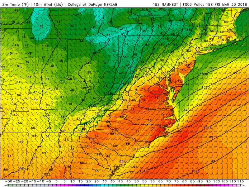
This afternoons high resolution NAM model showing the temperatures swings over the Northeast this weekend
Say It Ain’t So…More Snow?!
Back on Wednesday we discussed why it would not be all that shocking to see at least one more snow event, as we are in a very atypical pattern for this time of year, and one highly supportive of cold/snow. Since that time, all of our reliable model guidance has trended much farther north with a quick-moving frontal wave. This system looks to enter the country tomorrow afternoon along the West coast, and should continue to move very quickly east, reaching the Plains by Sunday afternoon. Its at this point snow should begin to break out over the Mid-West, as Canadian high pressure presses up against this wave, and supplies it with just enough cold air. By the early morning hours of Monday morning, precipitation should begin to move into the Mid Atlantic and possibly the Northeast, with the weak Canadian high pressure system just to the north.
While recent runs of the European model was the most bullish of the reliable model guidance on bringing light to moderate snow north of New York City, there are still some models that remain just to the south of the area. This is due to the very delicate nature of this weak frontal wave. At this point in time, I think we are not even close to seeing the final solution for this system, with shifts to the north and south both equally likely over the next 48 hours.
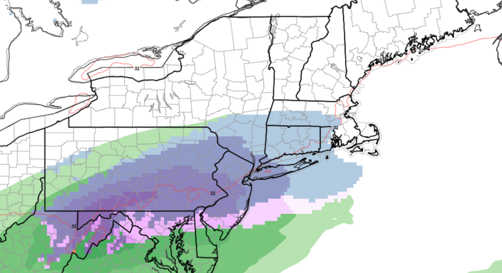
That being said some of the latest mesoscale models, such as the NAM and RGEM, as of late Saturday morning, have come in with more moderate to heavy precipitation further north. With the right entrance region of a strong upper-level jet running north of region, and some mid-level vorticity advection and mid-level frontogenesis these solutions seems reasonable at this time. However, snow accumulations may be limited to colder surfaces, to due initial ground warmth, some mixing with rain at the onset, and marginal temperatures overall, especially over New York City and urban areas. Also the with steadiest snow occurring closer to and few hours after daybreak, stronger solar heating in April may also keep paved surfaces or roads wetter.
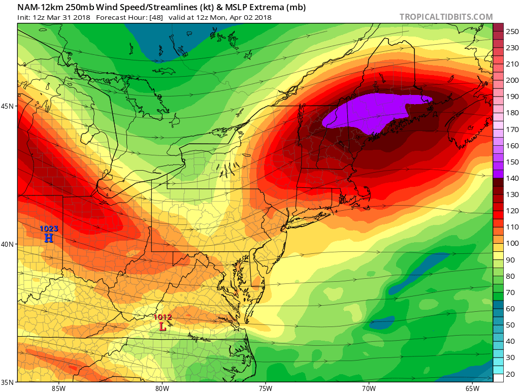
NAM model showing the NJ,NYC, LI, and CT area in the right entrance region of a 140kt+ 250mb level jet streak
As of now, what we know is that this system will not have that abundant amount of moisture associated with it, and it will be moving very quickly, making the event 6-8 hours long in total, with about .25″ of liquid equivalent. Additionally, we do have a fresh airmass to work with, which looks to be supportive of all snow for at least the interior and possibly even down towards the coast. Most importantly, the timing of the “heaviest” precipitation looks to take place during the early morning hours on Monday, which means we don’t have to worry that much about the April Sun angle, which would likely make this an all-rain system if the system arrives even six hours later.
Keeping all of this in mind, it appears that points north of the PA/MD line could pick up a quick 1-3″ of snow from this system Monday morning, with locations to the north of New York City maybe squeezing an inch or two of snow out of this system (mainly on grassy surfaces). This may impact the morning commute on Monday with slick roads and reduced visibility, but as of right now, this system doesn’t appear to be anything more than a nuisance system, with 90% of the snow melting during the afternoon hours. Now, there is a multitude of things that can change over the next few days, and I can almost guarantee that they will. Due to this, make sure to check back for the latest on this potential Spring snow as information continues to come in!
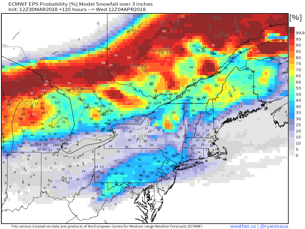
This afternoons European ensembles showing a moderate chance of 3″ or greater over portions of the Mid Atlantic and Northeast
Have a great Holiday Weekend!
Steven Copertino