-2")
Much Warmer Late Week, Cooler & Wetter Sunday & Monday
Good morning! We come bearing good news. Temperatures will begin moderating closer to seasonable levels over the next couple of days, which will lead us to very warm temperatures on Friday and Saturday. High temperatures may approach 80 degrees in many areas for the first time this year! By Sunday, however, much cooler air is likely to return, as a backdoor cold front moves to the south from New England. Another large storm system threatens to bring the region heavy rainfall by Sunday night and Monday.
Today and Thursday
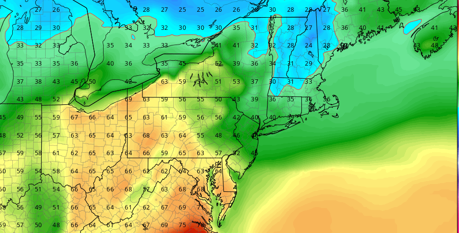
High pressure to the south will be in control today. Plenty of sunshine is expected with just some high clouds arriving this afternoon. After a very chilly start this morning with some interior locations falling into the 20s and 30s, light southwest winds and sunshine will help temperatures warm up into the lower to middle 50s this afternoon. More clouds are expected tonight, as a weak mid-level shortwave trough passes through the region. A few isolated showers or sprinkles are possible, mainly northwest of NYC, where some better lift in the atmosphere is present. Moisture will remain limited overall, so dry conditions are expected for most of the night. Cloud cover and some weak warm-air advection will keep temperatures a bit warmer than the last several nights.
On Thursday, more clouds will be around again, as a frontal system moves in from the Great Lakes into the Northeast. Some showers are possible, especially northwest of NYC as the warm front passes just north of the region. But moisture will be limited (again, sound familiar) so only light rainfall amounts are expected. Otherwise, temperatures will continue to moderate with the building southerly flow. High temperatures are expected to range from the upper 50s to middle 60s away from the coast. Southerly winds off the ocean may keep areas along the south shore of Long Island and Connecticut a little cooler, perhaps in the upper 40s to middle 50s for highs.
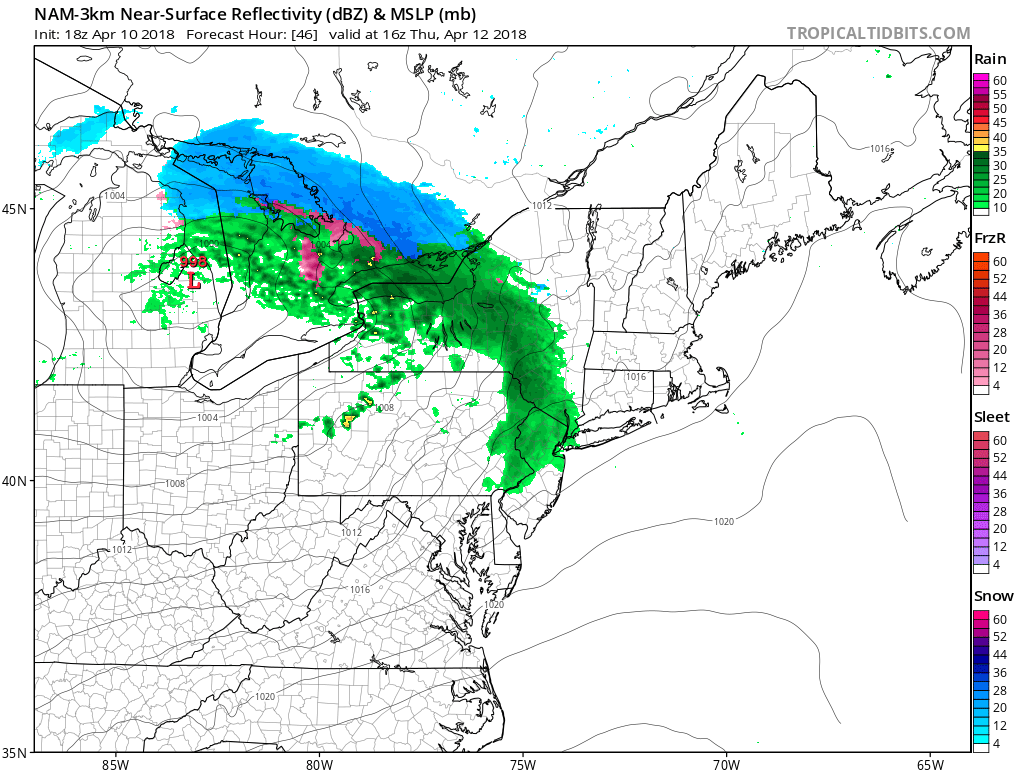
3km NAM showing showers during the day on Thursday, as low pressure tracks over the Great Lakes with a warm front extending further south
Friday and Saturday
A large storm system associated with a deep upper-level low and trough over the Central Plains, will cause more ridging to build over the East Coast during Friday and Saturday. This will support a deeper southwest flow with a much warmer airmass over parts of the Northeast. After possibly some early morning low clouds or fog, each day will clear out for more sunshine with temperatures rising into the upper 70s to lower 80s over New York City, New Jersey, and other areas just inland. These temperatures will be around 15 to 20 degrees above normal. Along the coast, including much of Long Island, afternoon sea-breezes developing will keep temperatures somewhat cooler. But overall both days look beautiful with more late Spring-like warmth, over entire the region.
But unfortunately this warm weather won’t last too long. A strong backdoor cold front will likely come through Saturday night, as high pressure begins building into Southeast Canada. Temperatures will fall into the 40s and 30s late at night. During the day on Sunday, very chilly and damp conditions are expected, with a backdoor cold front south of the region. It will be mostly cloudy with some showers, drizzle and fog around. Highs will likely struggle to reach the upper 40s to lower 50s. The ECMWF model has been showing some colder temperatures, which we think might be overdone. But there will still huge difference in how the weather will feel from Saturday with a much chiller airmass over the region.
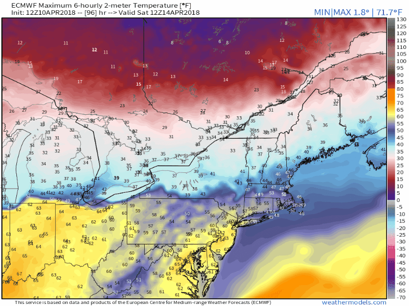
ECMWF model forecast 2m temperatures from Saturday to Sunday, showing the backdoor cold front moving south, over the Northeast US
Sunday night and Monday
The storm system over the Central Plains will be tracking into the Ohio Valley Sunday night and then into the Northeast on Monday. It will drag a frontal boundary with a triple-point low through the region. There are still some frontal timing differences on the models, but strong positive vorticity advection, with an amplifying upper-level trough and plume of sub-tropical moisture with high precpitable water values associated with the system will result in heavy rainfall by Monday.
Some instability and convergence may also result in some isolated to scattered thunderstorms. Instability is likely to remain too weak or elevated for any organized severe weather, but thunderstorms could produce torrential downpours that could lead more localized flash flooding. These thunderstorms may also be able to mix down some strong wind gusts, from strong low-level 925mb jet around 50-60kts, passing over the region by Monday.
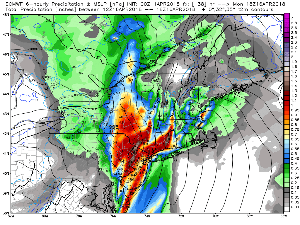
ECMWF model showing heavy rain over parts of the Northeast by Monday
Temperatures will begin rising again on Sunday night and Monday, as the warm front tries to lift northward. Then temperatures may get back into the 50s or 60s Monday, depending on far north warm front gets. But more cooler air will follow behind the cold front for the middle of next week. Overall, we anticipate below normal temperatures dominate next week, as some high-latitude blocking returns again and the pacific jet become active with more storm systems as well.
Stay tuned for more updates over next few days on the warmth Friday and Saturday and potential rainstorm Sunday night into Monday.