-2")
Heavy Rain & T-Storms Late Tonight into Wednesday, Warmer Times Ahead?
We have had some very nice weather, since the weekend in the Northeast. Plenty of sunshine with temperatures a little cool but overall closer to seasonal levels. But some very wet weather is on the way for tonight and tomorrow, before weather pattern begins improving again for the rest of this week and into the upcoming weekend. Then finally, a warming trend with some more summer-like temperatures will be occurring next week and as move into first few days of May.
Backing up to today, sunshine this morning will give way more cloudiness this afternoon, as a cut-off low over the Tennessee Valley this morning begins moving slowly northeast. Onshore easterly winds and cloud cover, ahead of this system will keep high temperatures a little cooler today—in the middle to upper 50s near the coast. But further inland temperatures will likely get into the 60s again this afternoon. Then rain will overspread the region from southwest to northeast tonight, as the cut-low begins interacting with shortwave energy coming out the Great Lakes and moves closer to region. Temperatures will likely remain warmer in the upper 40s to middle 50s with more onshore winds and cloud cover.
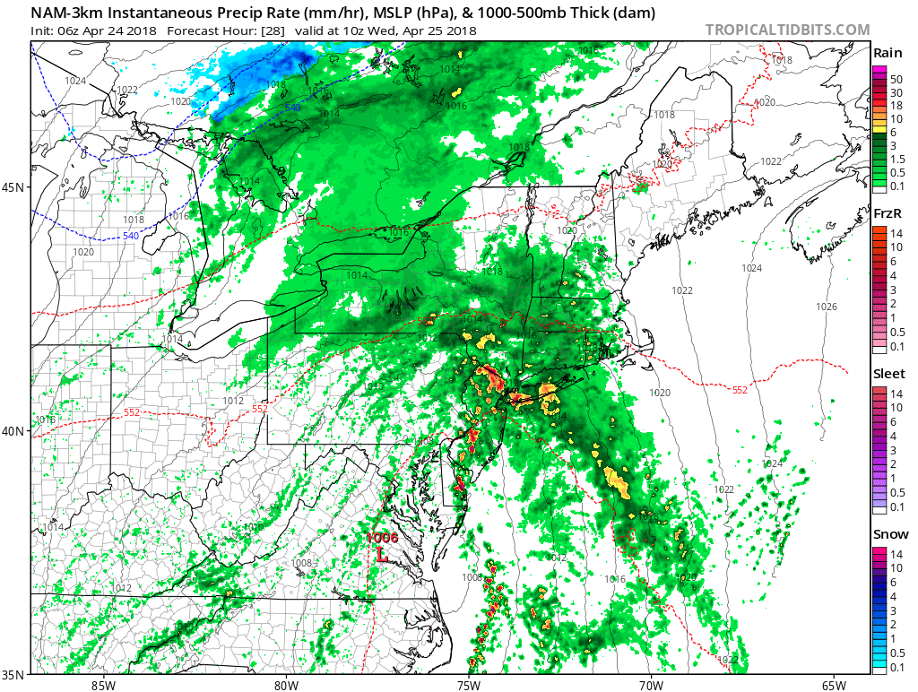
Upper level dynamics associated with this storm system are rather weak or disjointed. So rain will be initially be lighter and perhaps more intermittent early tonight. But a strong southeasterly low-level jet will moving northeastward through the region late tonight with increased mid-level warm-air advection and frontogenesis. This will enhance more lift for more moderate to heavy rainfall, over parts of region late tonight and tomorrow morning. Elevated instability levels will also be increasing and may support, some embedded or scattered thunderstorms around the region with torrential downpours.
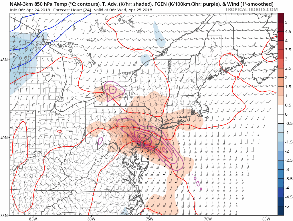
3km NAM model showing strong warm-air advection and frontogenesis at low-level jet at 850mb l moving southwest to northeast over Eastern PA, New Jersey, Southeast NY and Connecticut late tonight and early Wednesday morning.
High precipitable water values with strong moisture feed off the Atlantic, will support totals between 1”-3” are in some areas. This could result in some localized flooding , especially in poor drainage and low-lying areas. Some small from stream or river overflowing their banks, isn’t out of the question. However the recent dry conditions, should mitigate this type of flooding threat as well. Meanwhile, as the low-level jet passes over the region, onshore winds could be bit gusty to around 30mph at times, especially along the coastal areas. A few isolated gusts to 40mph are not question with any thunderstorms. But a stout inversion layer, should prevent 50kt+ winds around 850-925mb levels from the low-level jet, from mixing down in the surface.
Rain or thunderstorms should taper off by early Wednesday afternoon, as the low-level jet with better dynamics shifts to the northeast into the Central New England. Some cloudiness and more scattered showers may linger through the afternoon and evening hours. But temperatures may rise still into the 60s, in parts of the region, as more southerly winds continue to bring warmer air. Especially south over Central and Southern New Jersey, where there mostly likely to be a few breaks of sunshine. Then Wednesday night skies will be clearing late, as the storm system moves into the Northern New England and Canadian Maritimes.
On Thursday, a deep, dry westerly flow, behind the storm, will support more sunshine with high temperatures each day in the middle 60s. On Friday, another wave of low pressure will begin approaching from the south with increasing clouds. If this wave of low pressure comes close enough, some rain will be possible late Friday afternoon and night. But overall this system has been trending more progressive and farther offshore on the latest models. So we don’t think more think this system will have significant impacts the region.
During this upcoming weekend, some improving weather is likely. Some scattered showers are possible on Saturday, as a cold front moves through. But more westerly downslope winds may support more sunshine and temperatures well into 60s or even lower 70s, by Saturday afternoon. Then high pressure from over the Great Lakes will be build into region Sunday. A cooler, Canadian airmass will support temperatures a little below seasonal levels–in the upper 50s to lower 60s.
Then some pattern changes are expected as we head into the beginning of May. Next week, model and ensembles show a deeper trough over the Western Plains, that will lead to a stronger ridge building over the Eastern US. This could finally support several days of much warmer temperatures in 70s and 80s during mid to late part of the week. The ridge will also force any storm system to track well north and west of the region.
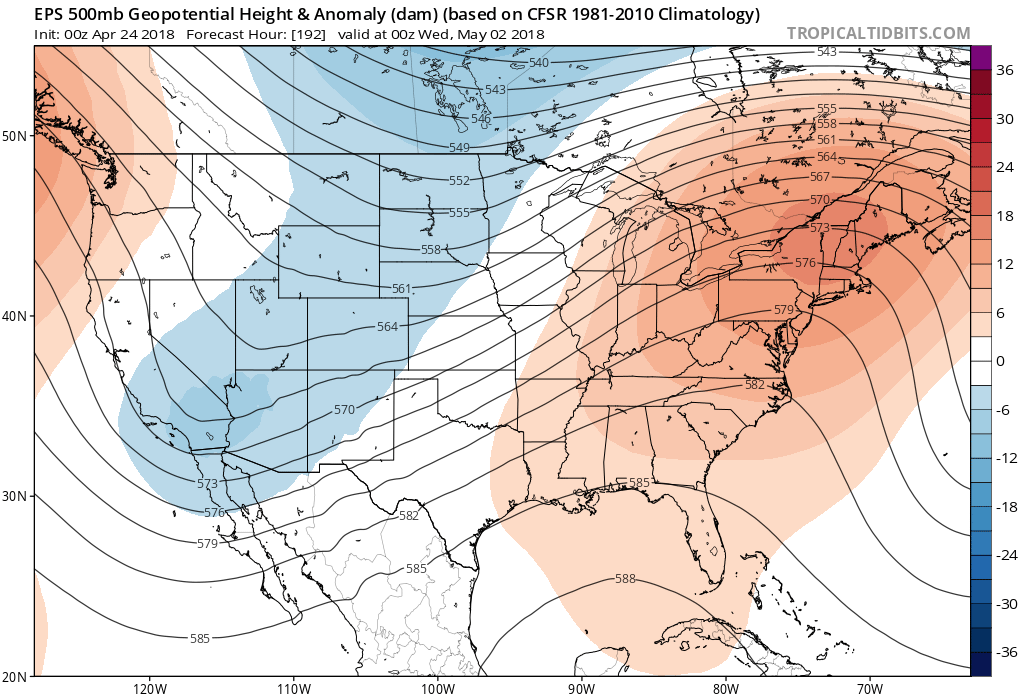
ECMWF EPS shows a deep trough over the Western US and strong ridge over the Eastern US with much warmer temperatures likely as we
But there is some question to how long this pattern will continue into middle of May. Some ridging with an -EPO or split flow pattern along the West Coast, may support more troughs over the Eastern US. Stay tuned for more forecast updates on our public blog or dashboard through the week! A special outlook post on May will also be out later this week!