Finally, a nice warmer stretch of weather is upon us! A developing storm system that will bring some severe weather with perhaps some tornadoes, over the Plains, during the next few days, will cause strong ridging to build over the Ohio and Tennessee Valleys and then into the Northeast US, for rest of this week. More sunshine and westerly downsloping winds will help temperatures rise into the middle to upper 70s this afternoon. Skies will remain mostly clear tonight with the ridge axis over the region. It will be a warm, comfortable Spring evening. Then during the overnight hours, temperatures will drop into the lower 60s over New York City and urban areas, while lows will be in the mid-upper 50s, over many of the suburbs.
On Wednesday ridging will become more flatter, zonal across the Northeast and Mid-Atlantic regions, as some shortwave energy from the Plains begins to ride along the top of the ridge, over the Great Lakes region. This will result in more west-southwest winds with high pressure positioned off the Southeast coast or near Bermuda. Temperatures will rise into the lower to middle 80s with mostly sunny skies for many parts of the region. on Wednesday. These temperatures are well above normal for this time of year. Closer to the south-facing shores of Long Island, New Jersey and Connecticut, sea-breezes will develop by the afternoon hours, and keep temperatures from rising out of the 60s or 70s.
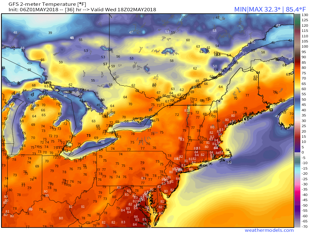
GFS model forecast temperatures over the Northeast on Wednesday afternoon.
On Thursday, another a stronger shortwave will be riding further south along the northern periphery of the ridge. This will lead to more compressed flow and gradient over the Northeast, supporting even warmer 850mb temperatures between 14°C to 16°C, center along the I-95 corridor from Washington DC to Boston. Temperatures will likely soar well into the middle 80s, with sea breezes keeping areas along the coast a little cooler. If there isn’t too much clouds from the shortwave or convective debris, temperatures will may reach the upper 80s or even approach 90°F in some spots. Humidity will also be higher with more dewpoints points in the lower to middle 60s. On Thursday night, partly cloudy skies are expected and temperatures may only drop in the middle 60s to lower 70s over much of the region.
But it will also become more active, over parts of the Northeast, as well late this week. A frontal boundary will also begin to develop along the gradient, over northern or central parts of New York and New England on Thursday. Instability from daytime heating and more moisture airmass, will also build along and south of this boundary. The aforementioned shortwave running along this boundary, will help trigger some showers and thunderstorms especially over the Interior on Thursday. If instability can juxtaposition with strong mid-level westerly flow at 50-60kts some isolated strong to severe thunderstorms with gusty winds, are possible over the Hudson Valley and New England. Further south, over much of New Jersey, New York City and Long Island stronger ridging, will likely keep any showers or thunderstorms more isolated.
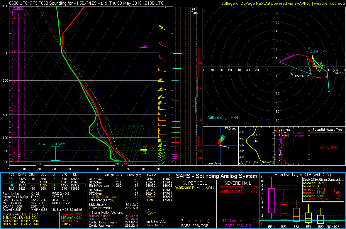
GFS model sounding with high instability and shear supporting some isolated severe t-storms on Thursday afternoon and evening in the Lower Hudson Valley
On Friday, a shortwave trough with a stronger cold front will move through the Northeast. This could lead to more scattered showers and thunderstorms, across the local region, as some instability builds again by the afternoon and evening hours. However, temperatures could still rise well into the 80s again before they arrive. Then the cold front moves through on later Friday night, with clearing skies and temperatures dropping into the 60s overnight. But cooler air still be slow move into the local region with west-northwest downsloping winds likely supporting temperatures to rise again into the 70s with more sunshine during the day on Saturday. Temperatures will likely return closer to normal levels by Sunday with highs in mid-upper 60s or near 70 in some spots. So overall a decent weekend appears to be coming up as well!
Next week (Monday) may get off to seasonable start with temperatures. as shortwave coming along the backside of trough over the Great Lakes and Ohio Valley, may interact with a disturbance near the Bahamas. We have to watch this system for any moisture to come northward. But the pattern will be more progressive with a lack of high-latitude blocking that supported more cooler temperatures for much of April. Thus we aren’t anticipating this system to have huge impacts on the region, yet. The pattern may active later next week with more disturbances moving through. Then ensemble guidance indicates troughiness over Western US, may support more ridging with warmer temperatures and severe weather again over Plains then East, as we head into towards the middle of the month! Stay tuned for more forecast updates during the week!
-2")