-2")
Showers Today, Warm & Dry Late Week, Memorial Day Weekend Outlook
Good morning! After beautiful weather to start the week, some cloudy, cool and wet weather is expected today and tonight, as a frontal system and upper-level trough moves through the Northeast. Fortunately, more pleasant and warm weather will return later this week, with temperatures several degrees warmer than normal. However, a part of Memorial Day Weekend may be unsettled. We give a more detailed breakdown of this week and weekend’s weather in the body of this article.
Today and Tonight
A warm front will be approaching the region from the west today. A shortwave in the middle of the atmosphere will ride this front, and when combined with the front’s warm air advection, some shower development is likely later today. Additionally, some weak elevated instability may support isolated thunderstorms with heavy downpours over parts of New Jersey and Eastern Pennsylvania later this afternoon afternoon. But no severe weather is anticipated, as these thunderstorms are likely to be elevated, with no instability near the ground. Cloud cover and onshore winds will keep temperatures in the mid-upper 60s today, for the most part.
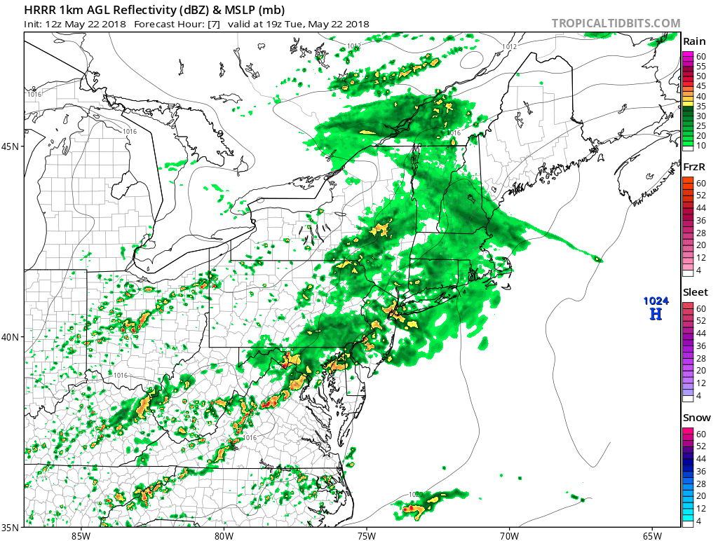
HRRR model showing showers and isolated thunderstorms over parts of the Northeast and Mid-Atlantic regions this afternoon
There may be a lull in the rainfall for a while this evening, as best forcing with the mid-level shortwave passes to the east. Then some additional scattered showers or a few isolated thunderstorms again are possible, as a cold front approaches from the west later tonight. Overall, light rainfall totals — under 0.50″ — are expected through tonight, for much of the region. But there could be locally heavier rainfall amounts in any isolated thunderstorm, with some minor flooding possible. Temperatures will likely hold steady tonight in the 50s, with skies remaining mostly cloudy. Some areas of patchy fog may also develop later tonight with residual low-level moisture and light winds.
Wednesday through Friday
Some clouds and showers may linger into early Wednesday morning, as the cold front moves through. Then high pressure from the southwest will begin building into the region for the rest of the day, allowing clouds to clear for more sunshine by the afternoon hours. With temperatures at the 850mb pressure level running between 10°C to 12°C, along with northwest downsloping winds, it is likely that high temperatures will be in the upper 70s to lower 80s across most of the region.
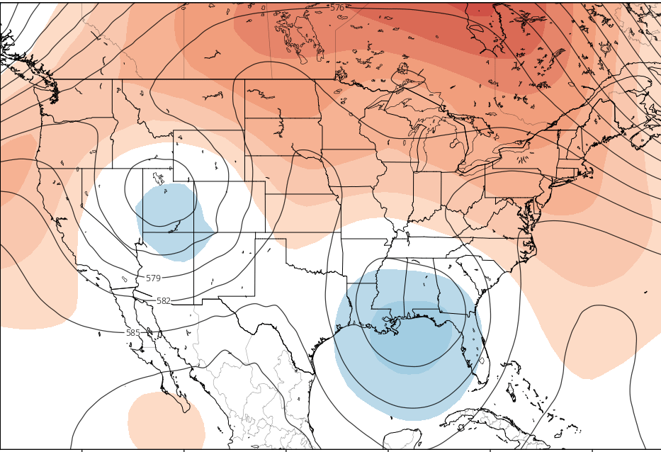
Then as an upper-level trough begins to enter the Western US, this will result in a large expansion of downstream upper-level ridging — stretching from the Plains into the Eastern US later this week. With 850mb temperatures rising to 12°C to 14°C, along with west-southwest flow and plenty of sunshine, it is likely that temperatures will rise into the lower to middle 80s — even near the shore — on both days. Humidity will be increasing a little each day, but will remain at mostly comfortable levels. Thursday and Friday nights will be mostly clear with low temperatures in the mid-upper 50s over Interior, and lower to middle 60s over NYC and urban areas.
Memorial Day Weekend
Unsettled weather may gradually return over the holiday weekend, as a cold front from the north moves southward and interacts with some tropical moisture over the Gulf of Mexico and Southeast US. But we do not expect a complete washout on any day of the weekend.
Saturday looks like the best day out the three with sunshine being predominant. It will also be warm and humid, with high temperatures in the mid-upper 80s. But some clouds may increase later in the day on Saturday, as a cold front begins moving from Canada into the Northeast. By Saturday night and Sunday, some scattered showers and thunderstorms are possible with this cold front. Some of these showers could contain heavy rainfall. As a result of more cloud cover and precipitation, Sunday should be a bit cooler, with highs only in the upper 60s to low 70s.
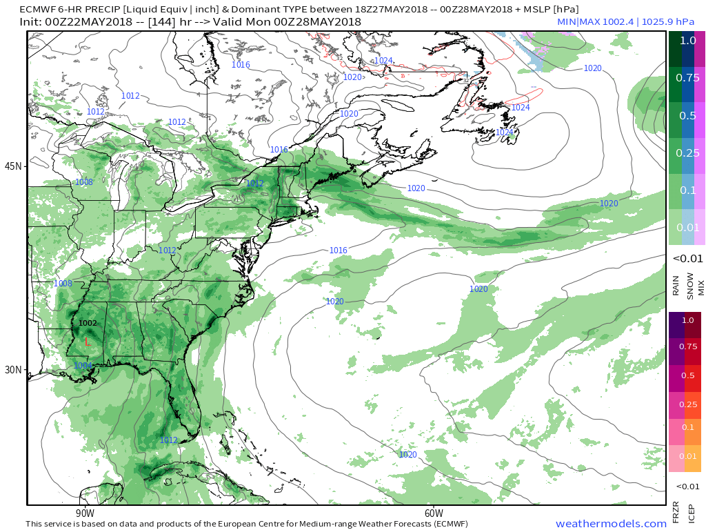
ECMWF model showing areas of rainfall over much of the Eastern US on Sunday with a slow-moving frontal boundary over the Northeast and Mid-Atlantic, and tropical moisture with low pressure over the Southeast US
Meanwhile, a weather disturbance over the Northwest Caribbean may organize into a tropical system, as it moves into in the Gulf of Mexico late this week. Most model guidance currently keeps this system over the Southeast US with some heavy rainfall through early next week, as a shortwave troughs mostly bypasses it to the north. But if this disturbance organizes into a stronger tropical system, it may enhance more ridging to north, forcing the cold front to stall somewhere over the Northern Mid-Atlantic region. This may lead to more showers and thunderstorms in the region on Memorial Day Monday. But uncertainty is still high regarding these details, due to it still being six days away, along with the complexity of the pattern.
We will be sure to provide more updates on Memorial Day Weekend later this week.