-2")
Memorial Day Weekend Weather & Tropical Storm Likely to Form in the Gulf of Mexico
Good morning! After some fantastic weather on Thursday, the next couple days, heading in the Memorial Day Holiday weekend will be feature more decent weather with increasing warmth and humidity. But some cooler and unsettled weather is store with perhaps some showers by Sunday and into Memorial Day Monday. Meanwhile, a lot of attention will be on a tropical storm likely developing in Gulf of Mexico during this weekend. We got more details in breakdown in the body of this post.
Friday and Memorial Day Weekend
Today will be mostly sunny and very warm with high pressure to the south in control. Temperatures will rise into the mid-upper 80s over with west-southwest winds this afternoon. A few spots between New York City and Philadelphia urban areas may reach lower 90s. Humidity will be a little higher this afternoon. For tonight, skies will remain mostly clear. It will be warm and turning more humid with more south west winds. Temperatures will drop in the 60s in suburbs and lower 70s over New York City and urban areas overnight.
Saturday is still looking like best day for outdoor activities for this holiday weekend. It will be a hot and humid day with sunshine most of the day. High temperatures will be in the upper 80s to around 90, for most areas away from the shores. However, by tomorrow evening a backdoor cold front will begin approaching from Central New England. Instability will build from the heat and humidity. Thus some isolated or widely scattered thunderstorms, could pop up during the afternoon and evening hours. The main threat with sub-tropical moisture airmass will be some heavy downpours and frequent lightning. So be on the lookout for this activity, while at a barbecue or at the beach. But most of the time will be dry.
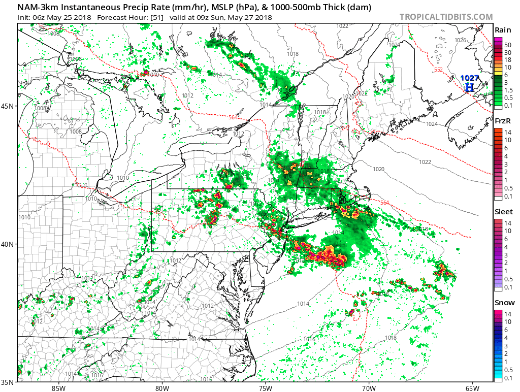
3km NAM model showing more showers and thunderstorms with heavy downpours over parts Northeast late Saturday or early Sunday morning
Once we move into late Saturday night and Sunday morning, more numerous showers and thunderstorms are likely, as a wave of low pressure develops along the backdoor cold front as moves further south into New York City metro region.. There could more areas heavy rainfall and localized flooding as sub-tropical moisture increases with high precipitable values approaching near 2.00″. Temperatures will be turning much cooler, as a maritime airmass moves in behind the front. The good news these showers and thunderstorms should begin winding during afternoon hours on Sunday, as the wave of low pressure with more focus for lift and instability, passes to the east. However skies are still be expected to be mostly cloudy, with spotty showers, drizzle or patchy fog still around.. This will keep temperatures from rising out of the upper 60s and lower 70s across the region.
On Memorial Day Monday, the morning will likely start with some clouds, patchy fog and perhaps some showers or drizzle again. But the backdoor door front will start lifting back northward as a warm front. So we should see skies begin clearing for a little more sunshine, by the afternoon hours with more southerly winds returning. This will help temperatures rise into the mid-upper 70s, over most of the region. Areas closer to shore and beaches will be cooler in the 60s or lower 70s.
Tropical Storm Likely to form this weekend in the Gulf of Mexico
A tropical disturbance over the Northwest Caribbean has been gradually becoming better organized over the past few days, despite some unfavorable upper-level shear. Currently convection remains disorganized around the center and the storm may maintain a eastern lop-sided appearance over the next few days. But there is now high likelihood this system will develop into a tropical storm, as moves northward into the Eastern Gulf of Mexico with shear decreasing this weekend. If it develops it will be named “Alberto” and it will be occurring before hurricane season officially begins in June.
The exact track of this system is uncertain till a well defined center forms, as is the case with more organized tropical cyclones. But most guidance currently indicates landfall somewhere between Southeast Louisiana and the Florida Panhandle. This storm will not likely have a lot of time to intensify into a hurricane, before making landfall. So the main hazard–regardless of whether this system gets named or not–is likely to be flooding from very heavy rainfall along Central and Eastern parts of the Gulf Coast and then further inland into Southeast US early next week. But we will continue to monitor this tropical system closely through holiday weekend, for further strengthening leading to more significant high wind or storm surge impacts for the Central or Eastern parts of the Gulf Coast.
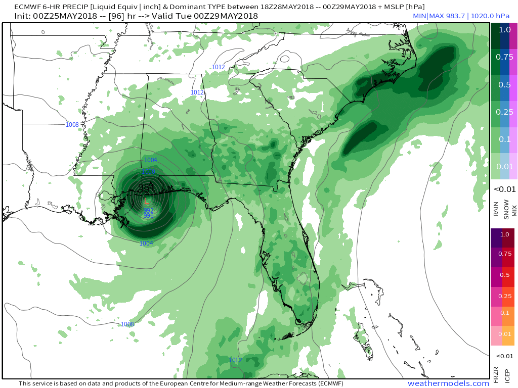
Latest ECMWF model forecast showing a borderline strong tropical storm/hurricane before making landfall near near Alabama/Mississippi border . This is stronger solution than many other models right now.
Back in the local region, high pressure from Canada builds into the Northeast after during the middle of next week. Temperatures will trend closer to seasonable levels in the middle 70s to lower 80s, with more pleasant weather, at least through Tuesday and Wednesday of next week. However, late next week some of the models show another incoming trough interacting with the remnants of this system or tropical moisture lingering over Southeast US. This could result in more unsettled weather with perhaps another area of low pressure, forming along the Mid-Atlantic coast by late next week or next weekend. But we will discuss that period more, next week. For now, enjoy the holiday weekend!