Good morning! What a wonderful weekend that was. After seven straight weekends with measurable rainfall, we finally broke the streak – and the heat built into the Northeast states on Sunday, with temperatures rising into the lower 90s. The heat will actually peak today, with temperatures expected to approach record highs for the day, in the middle 90s. 850mb temperatures (about 5000 feet above our heads) will actually be a bit cooler closer 19 to 20 C today, than what models had back last week. But the surface temperatures will warm as southwesterly winds increase.
In addition to the increasing surface temperature will come rising dew points, resulting in relative humidity values much higher than they were on Sunday. Heat Index values are expected to rise into the upper 90s and eventually near or over 100°F in many spots by this afternoon, especially over Northeast New Jersey and the Lower Hudson Valley.
Scattered showers and thunderstorms are possible later this afternoon and evening throughout the Northeast, as a old front and upper-level trough begins approaching from the north. Most thunderstorms will actually developing with a pre-frontal trough (Area of troughing ahead of the main cold front) in the interior portions of NY/PA this afternoon. Storms are then expected to track further southeast this evening. It appears that weak mid-level lapse rates, associated with warmer temperatures aloft, will limit the potential for stronger updrafts, and thus significant severe weather event isn’t anticipated for the Northeast.
However, guidance indicates lowering heights, increasing shear and some moderate instability building along the aforementioned pre-frontal trough. Despite the lack of a larger-scale severe weather threat, these parameters will still support the potential for some stronger or marginally severe thunderstorms. The main threats from the thunderstorms will be damaging wind gusts, frequent lightning and heavy downpours. Thunderstorms will also tend to weaken as they approach the NYC metro, with reduced instability and stronger mid-level ridging/subsidence remaining.
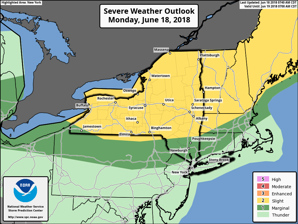
The Storm Prediction Center showing a marginal and slight risks for severe weather over much of the Interior Northeast today
Later tonight and early Tuesday morning, a few more showers and isolated thunderstorms with some heavy downpours/lightning can’t be ruled out, as the cold front and upper-level trough slides southward through the Northeast and Mid-Atlantic. By this time, instability will be decreasing with the loss of daytime heating, so these thunderstorms are not expected to be strong or severe. Otherwise, partly cloudy skies and muggy conditions are expected for much of the night.
Tuesday
Skies should clear for sunshine during the rest of the day on Tuesday as the cold front moves to the south into the Central Mid Atlantic. High temperatures will likely be in the mid to upper 80s in a large majority of the Northeast. However, some spots along the urban corridor from NYC metro and points south may reach 90°F, thanks to northerly downsloping winds. This could bring some areas to an official heat-wave (3 days of 90+ F). Mostly clear skies are expected Tuesday night with low temperatures generally in the 60s, perhaps in the upper 50s in the Interior valleys.
Wednesday
The weather takes an unsettled turn as we approach the mid-week period. The cold front which passed the Northeast states earlier in the week is expected to stall in the Central Mid Atlantic states. Meanwhile, another shortwave trough driving out of the Great Lakes will aid in the development of a low pressure along this front in the Mid-Atlantic states. After some sunshine early, clouds are likely to increase during the afternoon hours. There is a chance this wave comes far enough to produce a some rain or some showers over the New York City metro area by the evening hours. At the very least, heavy rainfall and thunderstorms are likely in the Mid-Atlantic states.
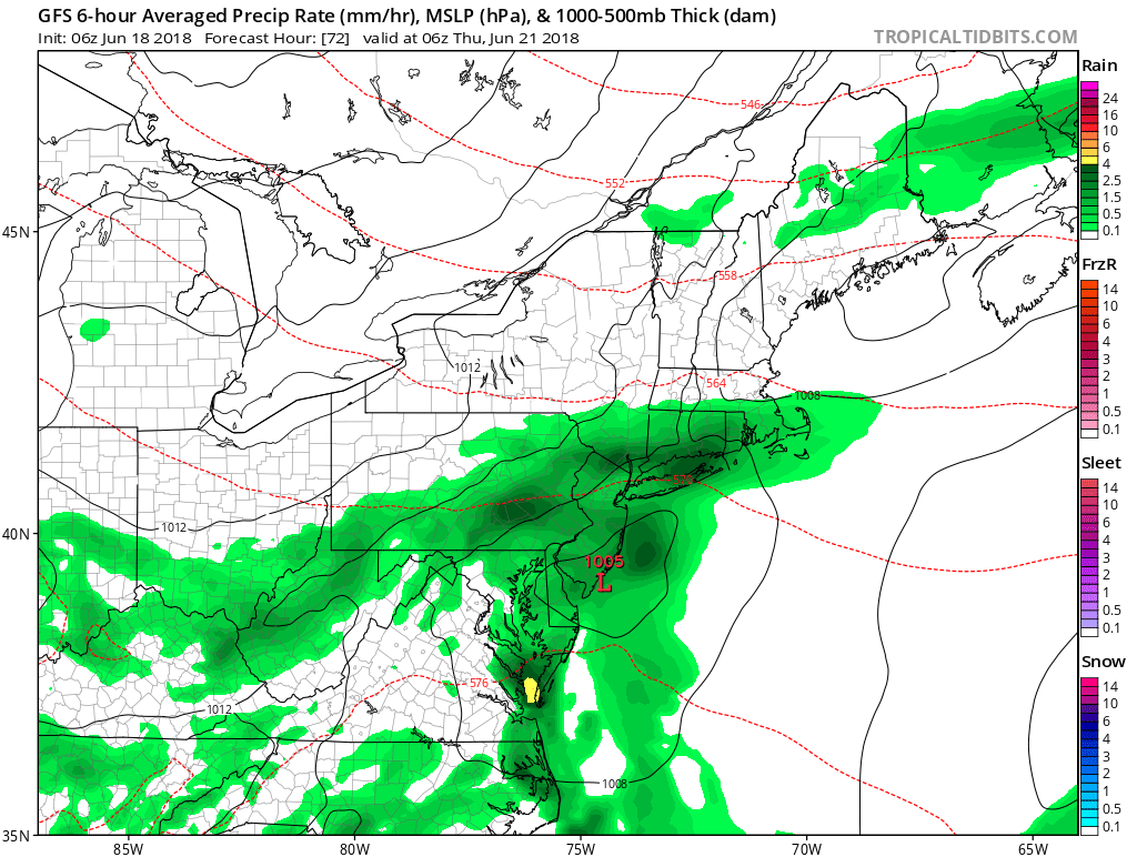
GFS showing a wave low pressure producing rainfall over parts of the Mid-Atlantic to Southern New England by Wednesday night
Thursday and Friday
Behind this low pressure system, high pressure builds southward from Canada, allowing pleasant, warm weather to return as we close the work week. High temperatures Thursday and Friday will likely average in the lower to middle 80s, which is closer to normal for this of time year.
Activity looks likely to return as the weekend approaches, with forecast model guidance suggesting a frontal system sliding through the Northeast on Saturday. The potential for showers and thunderstorms could return in this scenario.
Overall, we anticipate volatility in the pattern to continue over the next week or two. A split flow and some residual high-latitude blocking will likely support a stronger heat ridge over parts of the Central US, and frequent cold fronts and troughs sliding through the Northeast US through the end of the month. This will lead to “bursts” of heat, but short duration – in other words, a roller-coaster type pattern will continue.
There are some signs that heat could begin to become a more steady feature in the Northeast as we approach the early part of July. We’ll be keeping a very close eye on it over the next few days. Have a great Monday!
-2")