-2")
Prolonged heat wave set to begin on Friday
After several weeks of temperatures averaging largely below normal, the hemispheric weather pattern underwent a dramatic shift in early June. Since that time, much of the United States has observed temperatures above normal, with the lone exception being the Northeast states. That will change significantly beginning Friday, as a heat wave begins across a huge area of the Ohio Valley and Northeast – yes, including the urban corridor from Philadelphia to New York City and Boston.
The heat is expected to continue for quite a while. While a heat wave technically was observed in parts of New Jersey a few weeks ago, it will pale in comparison to the temperatures which are approaching starting this weekend – which may very well be the hottest of the year. The heat is expected to persist until the end of next week as a huge ridge builds across the Eastern and Central United States.
What’s causing this heat wave in the first place?
In the middle and upper levels of the atmosphere, a large ridge is forecast to expand across the Central and Eastern United States. There are many other processes driving this – some of them stemming from the Indian Ocean and Eastern Asia! – but the ridge itself is very likely to expand rapidly beginning Friday. As it does so, heights in the atmosphere will rise and a southwest flow in the lower levels of the atmosphere will allow very warm air to propagate into the Ohio Valley and Northeast States.
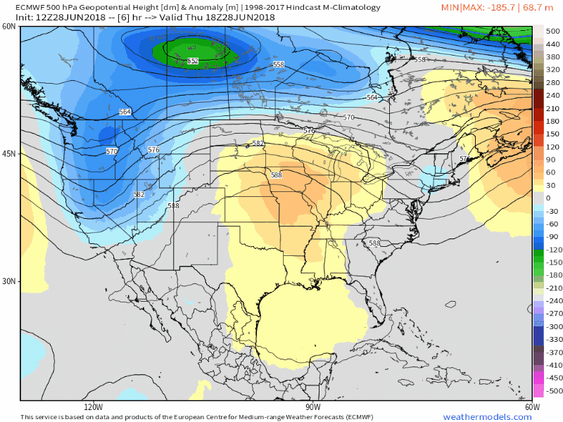
Models are in good agreement on a huge ridge expanding across a large part of the United States from this weekend into next week.
In the low to mid levels, around 850mb (or 5000 feet above our heads) temperatures will rise to 23-25 celcius. These numbers are important; 850mb temperatures near 25 C have been associated with some of the more significant heat waves of the past few decades in the Northeast states. To see forecast models suggesting these numbers is nothing to snooze at – there is the potential for very significant heat!
Most notable of all is the resilience and duration of the ridge and the very high atmospheric heights it is bringing with it. The Euro and GFS models both agree that heights will not only remain extremely high into early next week – they will actually rise as the ridge strengthens over the Central United States. A westerly flow in the low to mid levels will actually continue to advect very warm air into the Northeast states as the week goes on, with a secondary “peak” in heat possible towards the tail end of next week.
What days will be the hottest, and what preparations should I take?
The heat is expected to build from Friday into Sunday over the coming weekend. This will be the first “peak” of the heat. Temperatures on Friday will reach into the 90’s, likely the first day of the heat wave across the larger majority of the Northeast states. Saturday is likely to feature increasingly hot temperatures, and the peak of the heat will be on Sunday, as the core of warm air aloft moves into the Northeast States. On Sunday afternoon, temperatures could approach 100 F in many spots with Heat Index Values over 105 F.
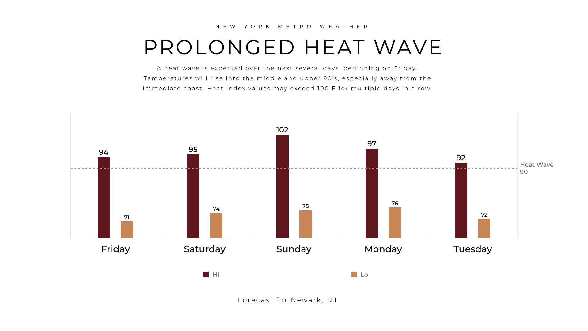
Our official forecast for temperatures in Newark NJ features a high of 102 on Sunday.
While temperatures will remain above 90 F in many locations during the middle of the week ahead, especially on Monday, a secondary peak in heat appears increasingly likely later in the week, probably on Thursday or Friday, when temperatures will again reach into the middle or upper 90’s. Temperatures during the heat wave will be cooler near the ocean and local waters, as usual, with a breeze coming inland on some days from the Atlantic and cooling things down quite a bit during the afternoon.
Preparations during heat waves are quite important, and it is critical to remember that heat related symptoms often occur rapidly. First and foremost, during heat of this nature, limit your outdoor exposure, especially when conducting physical activities. If you are outside, be sure to drink plenty of water. Hydration is a key aspect of staying safe during heat. It is also important to keep a close eye on children, the elderly, and pets as they are more prone to heat related illness. Be sure to have a plan in place in case someone near to you becomes ill, or you lose power in the heat.
Over the next several days, stay tuned for more information on the incoming heat wave. If you’re headed down to the shore, this is likely the best week of the entire summer to do so – so you are in luck. Load up on the sunscreen, be safe, and stay hydrated. More to come over the weekend!