-2")
Weekend Planner: Unsettled Weather with Saturday Night Coastal Storm
Good evening! After some beautiful weather over the past few days, more unsettled, wetter and muggy weather is likely again this weekend. This comes as a large upper-level low moves into the Ohio Valley and a coastal slow. develops and moves northward along the Eastern Mid-Atlantic region. It may not be good day to go down the New Jersey or Delmarva shore on Saturday, as they will likely be some rough surf with some more rain arriving. But neither Saturday nor Sunday will be a complete washout for the much of Northeast or Mid-Atlantic, as the coastal storm should move progressively.
First for tonight, skies will be mostly clear much of night, some high clouds may arrive late tongiht. But will overall it will be a pleasant summer night with temperatures dropping into mid-upper 60s over the urban areas and upper 50s to lower 60s over the suburbs. More sunshine perhaps filtered through some high clouds, is expected during the morning hours on Saturday. Then clouds will quickly increase and during afternoon hours, as the coastal storm along a frontal boundary and tracks northward from the Carolina coast. Then shortwave energy, over the Southeast US, will be causing more the upper-level low amplify with a negative tilt. This will cause the low to slowly deepen and get pulled north-northwest inland over the Northern Mid-Atlantic region.
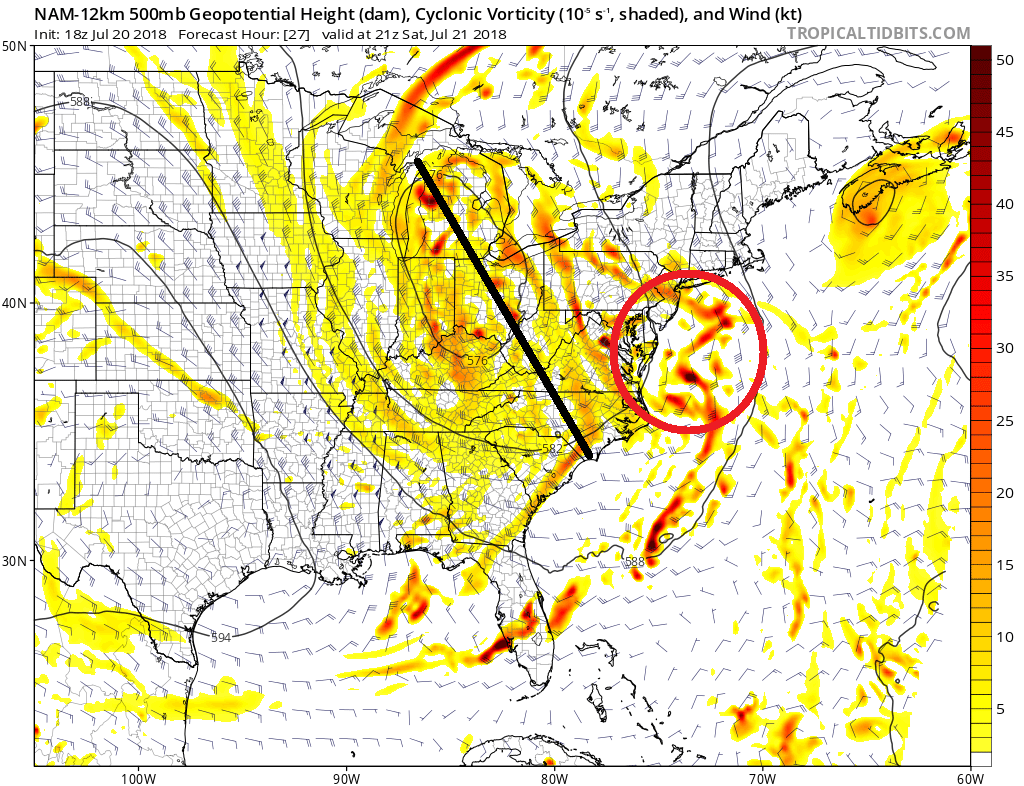
NAM model showing the large upper-level low over the Ohio Valley, with a negative tilt as shortwave along streams northward along the Mid-Atlantic region.
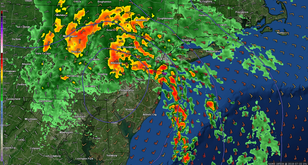
Some moderate to heavy rainfall, will likely spread northward into the Delmarva region, Southeast PA and Southern NJ by tomorrow afternoon, with onshore easterly winds becoming gusty along the shorelines for those areas. Further north, some subsidence from departing high pressure will likely support drier conditions throught out much of the day. But some showers could push northward in New York City metro, Northern NJ and Long Island, by the end of the day. High temperatures with more clouds and onshore winds, will likely fall several degrees below normal in the mid-upper 70s, across much of the region.
Tomorrow evening is where weather conditions really begin to worsen over Northern New Jersey, Southeast New York and Southern New England. Model guidance indicates this coastal low will be some type of hybrid of system with both tropical-like and non-tropical characteristics. This system will have bands of rain and some convection rotating around a small circulation, enhanced by mid-level frontogenesis and strengthening easterly low-level jet. This will be move northward into this region during the evening and overnight hours. Also a tight pressure gradient and 50-70kt low-level jet, will probably lead some windy conditions along the coast Saturday night. While some low-level inversion will should keep more damaging winds from mixing down to the surface, wind gusts could still gust up to 40mph at times.
Tropical moisture will result in precipitable water values between 2.0″ to 2.5″ with potential for some training thunderstorms embedded with bands of rain. Thus some very heavy rainfall and localized flash flooding is possible in some areas. Model guidance showing for 2″ to 5″ of rainfall in some parts of the Mid-Atlantic region, particularly the west side of the storm. As instability increases in the warm sector, we will also have monitor directional shear also enhanced by the strong low-level jet, on the east side of this storm. This could support isolated damaging wind gusts near 60 mph or weak tornadoes, from thunderstorms, late Saturday night or early Sunday morning, as the coastal storm begins lifting north of the region.
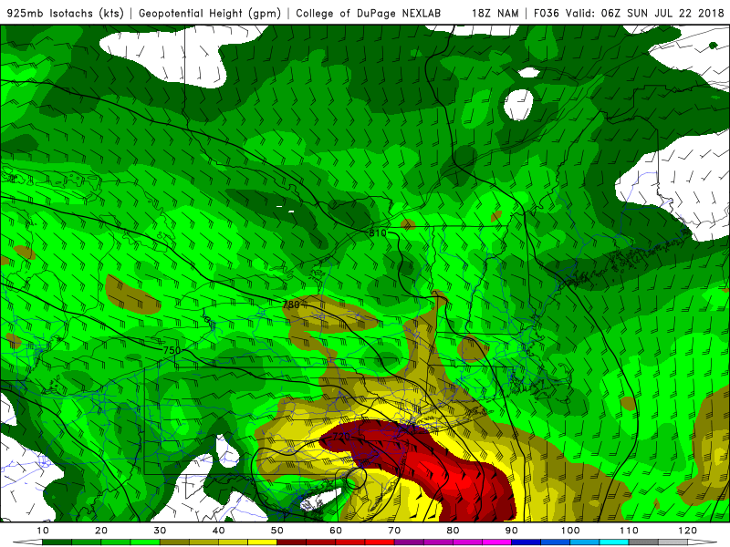
NAM model showing the easterly low-level jet with 50-60kt winds at 925mb (2500ft) over New Jersey, Saturday night
Rain will likely begin tapering off around daybreak Sunday, as a mid-level dry slot comes in behind this low. Then for the rest of Sunday, clouds will break for some sunshine at times. More southerly winds will support a very warm and muggy airmass with temperatures reaching the lower to middle 80s again. But a few more scattered showers and thunderstorms are possible, as the tropical moist-airmass with daytime heating will cause instability to increase during the day.
Taking a look at next week, it will likely be very warm and muggy overall, with some unsettled weather likely each day over the Northeast. The upper-level low will open up and weaken over Ohio Valley. But tropical moisture will continue to stream northward along the periphery of the Western Atlantic ridge. Thus depending on the strength ridge and other disturbances moving through the region, they will be some chance of some scattered showers and thunderstorms with heavy rainfall and flash flooding each day, especially during the afternoon or early evening hours. Some isolated strong to severe thunderstorms are also possible with gusty winds.
We may not break out of this unsettled and wetter pattern for a while, as well. Overall the MJO/tropical forcing in phases 6/7 over the next few weeks, favors a ridge over the Western US and a deeper trough over the Ohio Valley. This will allow the Western Atlantic ridge build at the times, with more warm and muggy days with tropical showers and thunderstorms, perhaps for the rest of the month. This could result in above average rainfall for the month overall in parts of Northeast and Mid-Atlantic. Which would be a big change from drier conditions in past few weeks. In the meantime, stay tuned for more updates on the coastal storm for Saturday night and more scattered storms afterward, through the weekend!