-2")
NYC Area Forecast: Ridiculous dew points take a break (for now)
For what feels like weeks on end, dew points have averaged well above normal and temperatures in the 80’s and 90’s have made the airmass feel oppressive in and around the NYC Metro Area. Such was the case again over the past few days, with warm and moist air in place over the weekend. Showers and thunderstorms were commonplace once again, with many areas receiving several inches of rainfall.
The weather pattern which brought us weeks of humid air looks likely to take a temporary hiatus this week – but it’s not going away for long. Although humidity levels will drop over the next few days, the pattern will remain transient, and there are already signs of the return of heat in 7 to 10 days time. Here’s how we expect things to shake down:
Monday & Tuesday
The week should begin relatively inauspiciously, with temperatures a bit cooler and humidity levels down as well. You can thank high pressure nosing southward from New England for that, with the northeasterly flow bringing in lower dew points and generally more pleasant air. The high pressure won’t be long for its stay here, as a more significant storm system develops across the Central United States later on Monday.
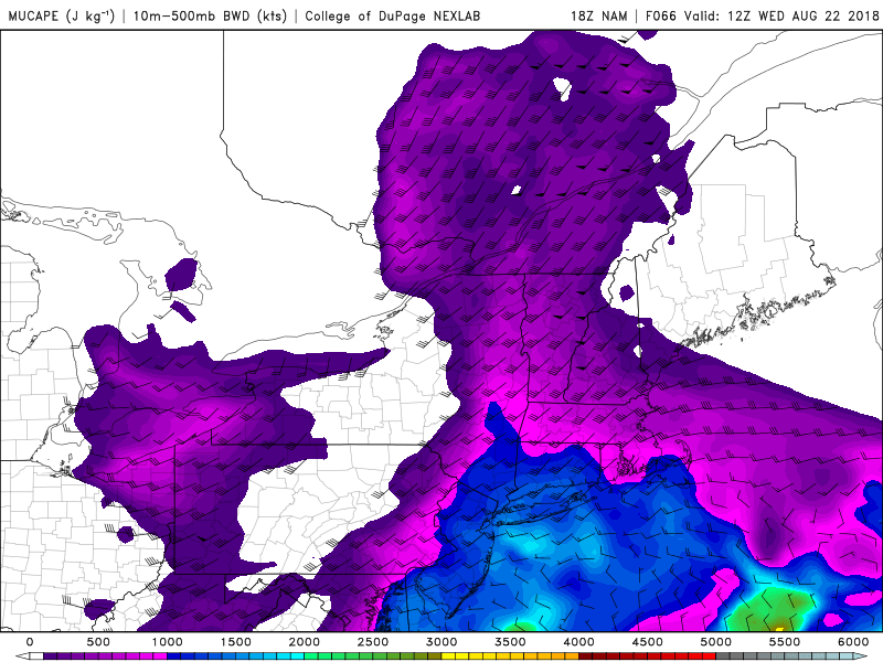
Instability increases on Tuesday Night and Wednesday morning as a front passes, which could lead to a few storms.
The system itself is likely to head northward into Canada, but as it does so it will bring southerly winds back into the picture for the Northeast. This will result in increasing dew points – and humidity – as a warm front approaches on Tuesday. A frontal boundary appears likely to move through portions of Pennsylvania, and with increasing instability as the system approaches, the potential will exist for some strong thunderstorms.
These storms appear likely to move into New Jersey and perhaps the NYC Metro area and New England, while weakening on Tuesday evening into the early morning hours of Wednesday. While a severe weather threat isn’t currently anticipated, we certainly could see a few thunderstorms wtih heavy rain and lightning through the early morning hours of Wednesday.
Wednesday through Friday
Gradually, a frontal boundary will slide eastward through New England on Wednesday, ushering in the relief we have all been waiting for. Dew points will fall into the 50’s and temperatures will remain warm and comfortable. High pressure is expected to take control from Wednesday afternoon through Thursday. While not overly anomalous for this time of year, the airmass will simply feel great compared to the humid and hot airmasses we have been experiencing.
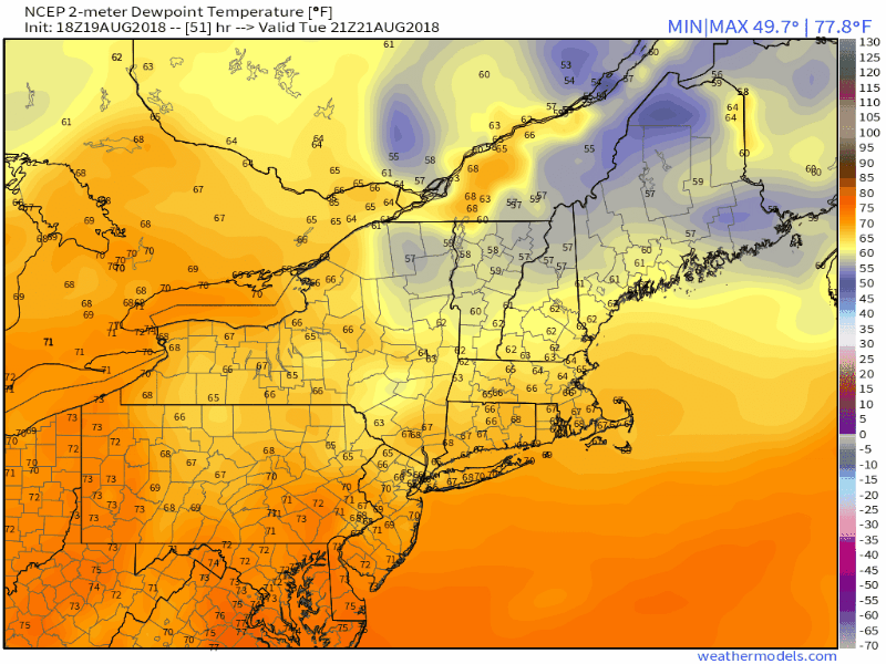
A major airmass change is modeled this week with dew points falling into the 40’s.
While a few spotty showers are possible on Wednesday and Thursday afternoon, a much drier airmass will be in place – so we aren’t currently anticipating anything significant. High pressure will remain in control and temperatures well average near or below normal for this time of year. This 3-5 day stretch will be one of the nicest in a while.
Friday and beyond
The cooler and drier weather will be on a race against time as next weekend approaches. The atmosphere is set to undergo significant changes in the Northern Pacific ocean, which will lead to major changes here in the Lower 48 states. Eventually, ridging is expected to expand and temperatures will rise to above normal values once again. In fact, forecast models suggest that by the middle to end of next weekend, temperatures could be rising several degrees above normal.
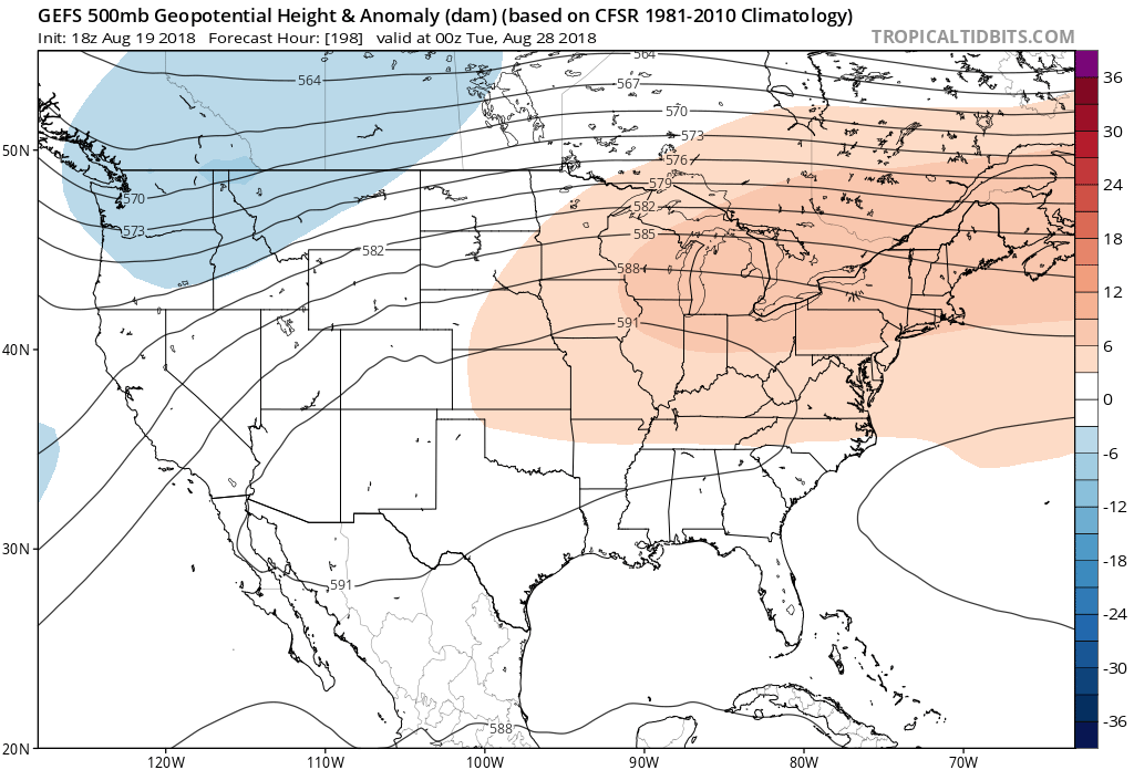
A major ridge returns by next weekend and will bring heat back into the forecast.
In addition, as we grow towards the Day 10 time frame (early next week) there are already signals that in addition to the heat, humidity will build – and the opportunity will arise for thunderstorms on multiple days. The synoptic weather pattern being signaled by ensemble guidance at this range is one that typically features above normal temperatures and opportunities for thunderstorms in the Northeast states.
We’ll have more on the expected pattern development as this week goes on – for now, enjoy the upcoming stretch of cooler and drier weather!