-2")
On Florence, and her uncertain but concerning future
“What would normally happen in this scenario?” Most meteorologists would be uncomfortable telling you how many times we utter this phrase in our own heads, but the truth is that it happens quite often. In all honesty, this method usually serves as a bit of a reality check; what kind of analog years can we use to compare this upcoming storm to, and how did similar scenarios evolve in the past? This forecasting process isn’t fool proof, but it usually works out – properly weighting past events into forecasts helps produce a more reasonable expectation.
But there are times when it simply doesn’t apply – where model guidance shows a highly unusual pattern ahead, so much so that past events will do no good to help us understand what will evolve. Hurricane Florence may very well be a shining example of just that.
Florence’s Current Status
Tropical Storm | Winds: 65mph | Pressure: 996hPa | Movement: NW 7mph
Currently churning northwestward through the Atlantic Ocean, Florence has weakened quite a bit over the last 24 hours. After rapidly strengthening, the storm has succumbed to moderate wind shear over the last 12 hours in particular, with the majority of impressive convection blown to the east of the storms center.
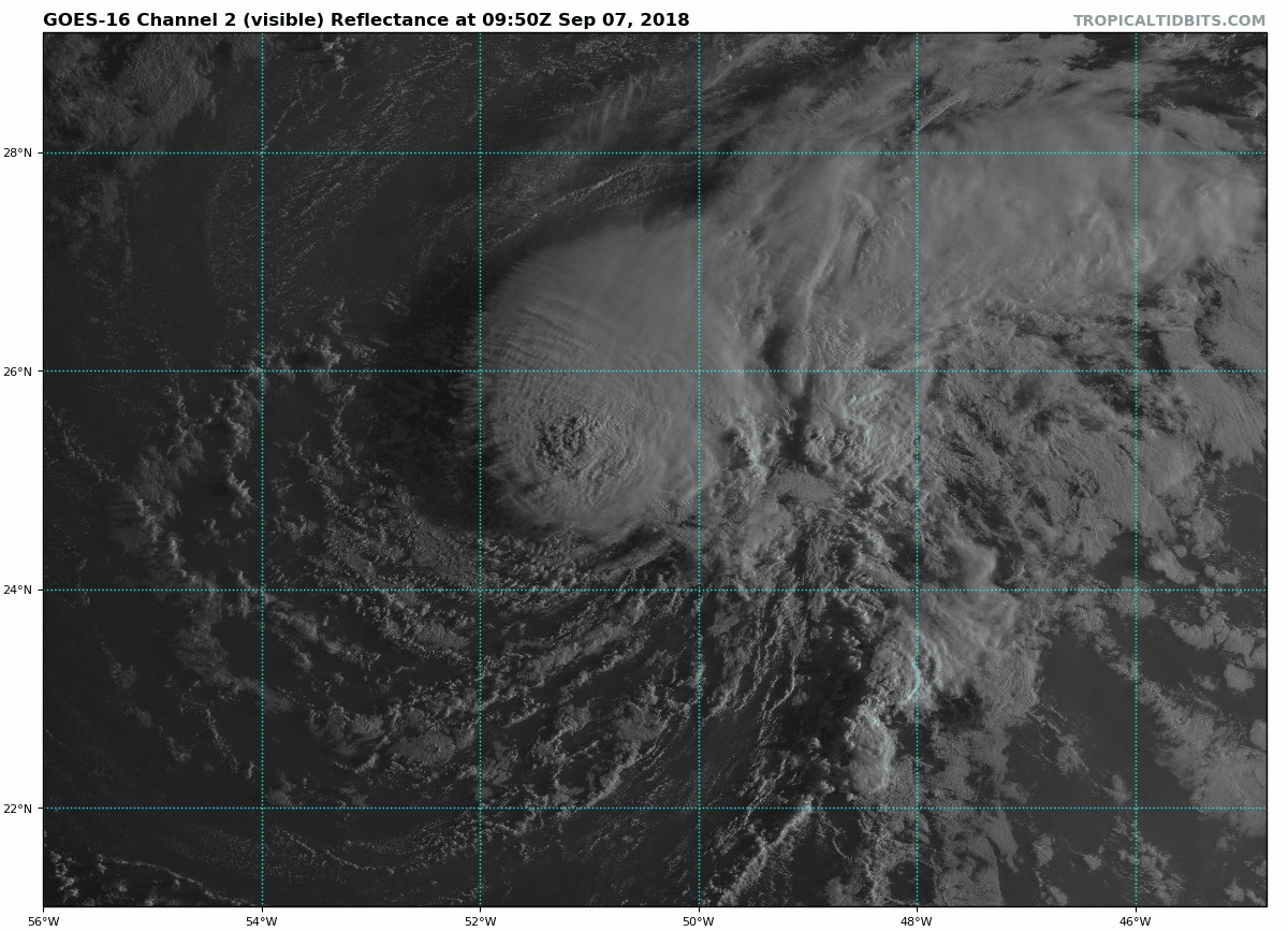
Visible satellite loop of Florence this morning.
The system is expected to continue weakening over the 12 hours or so as moderate wind shear and less than favorable sea surface temperatures persist. Forecast models suggest rising pressures through Thursday evening and after the downgrade to a Tropical Storm yesterday, the system may maintain that characteristic for an while longer.
Florence’s Future and Reason For Concern
Hurricane Florence is expected to continue a westward turn through the weekend, while beginning to strengthen yet again. Forecast models are in good agreement that the system will enter a better atmospheric environment for strengthening; wind shear will weaken and the storm will approach warmer waters.
It is at this point, later this weekend and early next week, when the track of Florence becomes problematic. Models suggest that the storm will continue westward towards the US East Coast, making an approach sometime during the middle part of next week. Such a forecast at this range typically wouldn’t be overly concerning, but there is reason for pause during this specific scenario.
The synoptic pattern surrounding Hurricane Florence is forecast to be quite anomalous – so much so that forecast models showing more concerning solutions need to be considered. Most notably, forecast model suggest that an anomalous ridge will develop on the north side of Hurricane Florence from late this weekend into early next week.
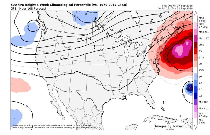
Models suggest an anomalously strong ridge will guide Florence towards the USA next week.
Aided by fluxes from the North Pacific, Typhoon Jebi, and more, the ridge is expected to be quite large and strong. In fact, the ECMWF and GFS Ensembles are both suggesting that the ridge will lie on the outer periphery of climatology for this time frame – one of the stronger ridges observed in that area at that time.
Such an occurrence lends credence to the idea that Florence will be forced westward into a precarious position next week, angling towards the Southeast US Coast and then readying to take a turn northward. The specifics, of course, are unknown – and probably won’t be known for several days still. But concern is rising for East Coast impacts overall.
Over the past 12 to 24 hours in particular, forecast guidance has begun to cluster a bit further with Florence’s track. Initially, many models suggested the storm would track seaward. Ensembles in particular have clustered further west/southwest over the past 24 hours, with the suggestion that the storm will move towards the Southeast US or the Mid-Atlantic coast during the middle part of next week.
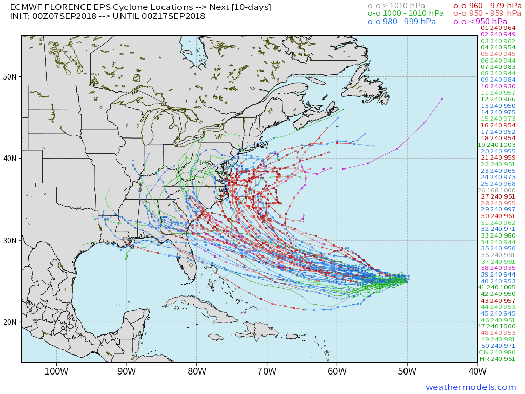
The latest Euro Ensembles showing a varying set of tracks for Florence – most of which impact the Eastern US in some form.
What to do now
If you live along the US East Coast – anywhere from Florida to Cape Cod, you should be considering the possibility of hurricane impacts without panicking. The storm is still several days away and the track is extremely uncertain. Still, it does not hurt to be prepared. Dust off your hurricane plan and preparedness if you live near or along the coast. Know your hurricane evacuation routes and check your local flood zones. These are things you should do every year – but now is a great time to revisit them.
In addition, keep a close eye on the forecast. In the coming days, we will begin to gain confidence on further specifics in regards to the track of Florence. For now, monitoring the forecast and being comfortable with your hurricane preparedness is key.
As always, keep it tuned to our blog and our social media accounts. We’ve got the latest information streaming in 24/7.
Love the weather posts John, keep em coming!
Thanks Stephen! And thank you for reading. Cheers!
Very good post. Thank you for the well rounded discussion.
Thanks for reading!