-2")
Florence set to rapidly strengthen, likely to impact East Coast
Tropical Storm Florence is getting ready to put on a show. The storm has been floundering for a few days now, battling moderate wind shear and less than ideal water temperatures. It has maintained Tropical Storm status, but has weakened quite a bit with structural deficiencies very apparent on visible satellite imagery as recently as last night. Things have changed quite a bit so far today, with the storm regaining structure and beginning to intensify.
Forecast models are in good agreement that the storm will begin to intensify later today and Sunday, as wind shear weakens and it begins to traverse increasingly warm water. The situation becomes more precarious in the next few days, as the environment around Florence becomes conducive for rapid strengthening. Forecast models suggest the system will restrengthen into a Major Hurricane as it accelerates westward, on a track perilously close to the United States. The NHC is forecasting rapid intensification.
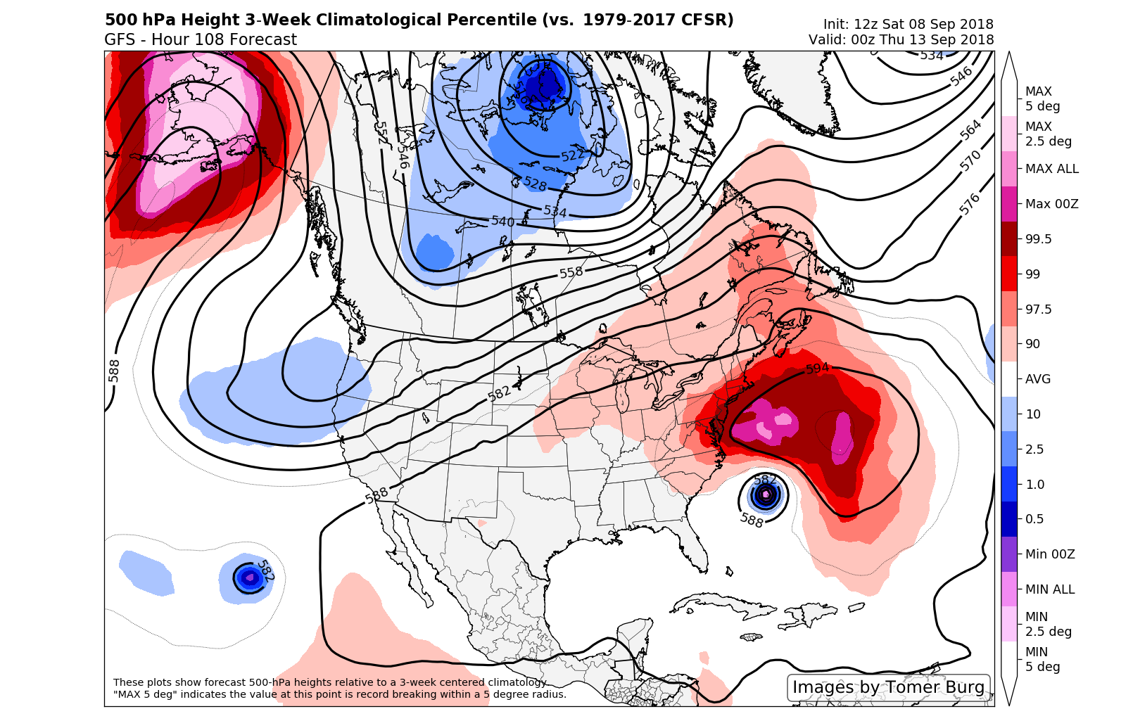
Forecast models suggest a highly anomalous ridge will build north of Florence and force the storm toward the USA.
The synoptic evolution around Tropical Storm Florence remains fascinating for its convoluted and intricate nature. The system continued on a northwest heading as recently as Friday before turning westward, all thanks to a building mid level ridge to its north. Its current position is unprecedented when factoring in the forecast – no storm has ever been at this latitude and made landfall in the United States.
The atmospheric setup has been telling us for days, however, that there is nothing “normal” about this storm system or the pattern around it. Forecast models and ensembles are in good agreement that a nearly record-breaking ridge will build north of Florence, forcing her westward towards the United States. This ridge is on the outside edge of climatology; in other words, its extremely abnormal and anomalous.
An increasingly concerning forecast
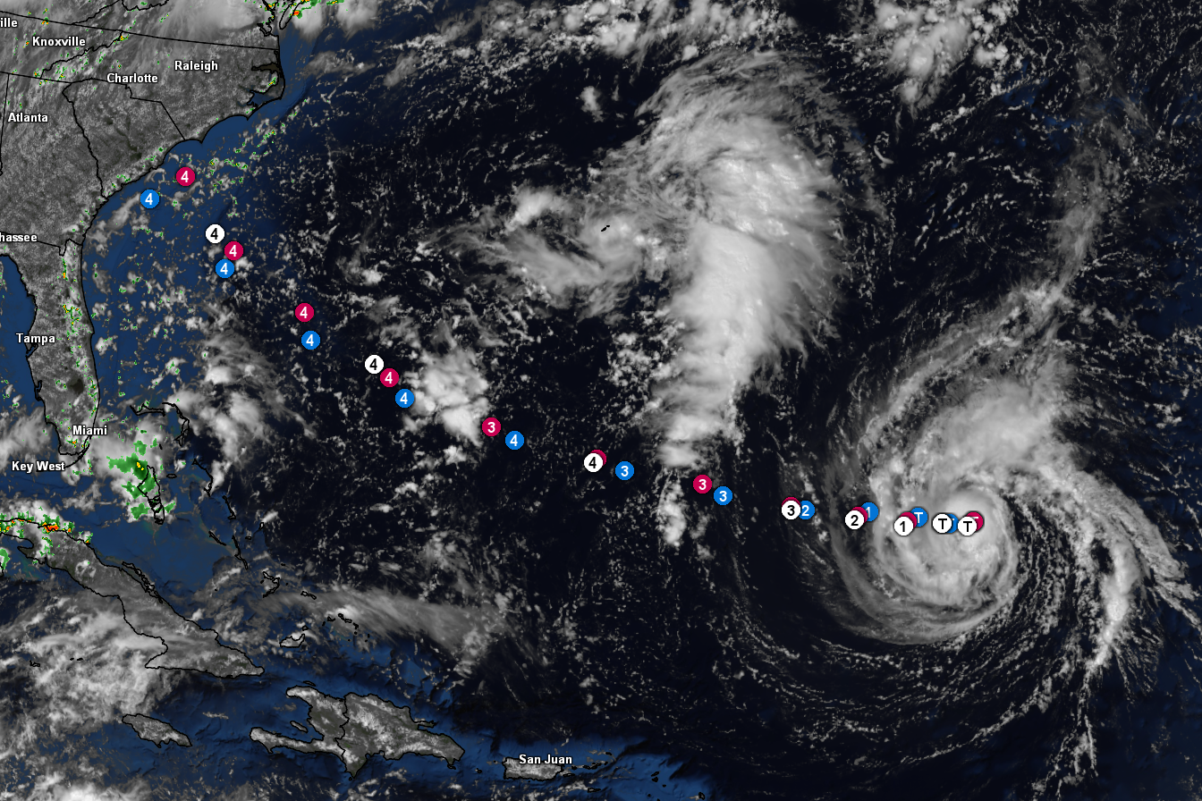
Various model and NHC (white) points for Hurricane Florence overlayed with visible satellite imagery as of 130pm today.
While the exact location (or even the occurrence) of landfall remains uncertain, the situation is becoming increasingly concerning for interests in the Southeast United States. Ensemble guidance has steadily trended westward with the overall track of Florence over the next few days, placing the clusters or consensus track near the coasts of the Carolinas. The GFS remains further east while the ECMWF brings the system into the Carolinas directly, but both have been trending towards the coast.
Making matters much worse is the fact that the storm is likely to be strengthening considerably in the days prior to its approach toward the coast. Improved ventilation (an anticyclone interaction next week), very warm ocean temperatures and very low wind shear all seem likely to contribute to a Major Hurricane and the possibility of steady strengthening and expansion of the systems size and intensity.
It is a distinct possibility that by early next week, Florence will be a Major Hurricane on a collision course with the Southeast US shoreline.
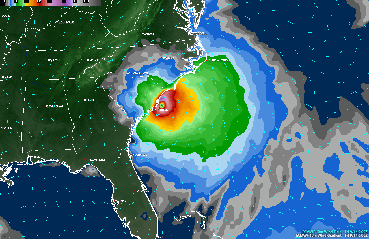
The ECMWF model suggests a direct impact on South Carolina next week.
Still, the specifics remain uncertain. Models have waffled with where Florence will make landfall – or if will at all, with the possibility that the storm will simply sit offshore for a few days before moving seaward. In all likelihood, the specific landfall location of the storm won’t be determined for a few days still. Small changes in the systems behavior over the next few days will have major implications on the forecast moving forward.
Further northward, the concern will be heavy rainfall should the storm make it inland. Forecast models suggest a synoptic pattern conducive for a stalling, looping or meandering tropical system with very little impetus to move the storm away from the East Coast for several days. Should the storm make landfall, many areas could be at risk for several inches of tropical rainfall.
What to do now and in the days ahead
For the NYC Area: Direct impacts from Florence are not anticipated, but it remains prudent to review hurricane plans and preparedness as a precaution. Indirect impacts are still a distinct possibility in the form of high surf and swells, rip currents and heavy rainfall.
If you live in the Southeast States, particularly on the coast of the Carolinas, now is the time to begin reviewing your hurricane plan and emergency preparedness steps. Look at your evacuation routes, begin early home preparation steps, and learn your flood zones. If you don’t have a hurricane kit, invest in one. Consult your local emergency management officials for details on what the plan could possibly be next week.
If you live further north or south along the East Coast – from Florida to Georgia and from Maryland to New Jersey – keep a close eye on the forecast. While landfall is very unlikely here, it doesn’t hurt to be prepared, and indirect effects from the storm are still possible. It’s better to be prepared than to scramble at the last moment.
Finally, pay close attention to the forecast over the next 48-72 hours. Things will begin to come into much greater focus and you should be ready to put a plan into action at that time.
Leave a Reply
Want to join the discussion?Feel free to contribute!