-2")
The Weekender: Tropical update, winter analog ideas
Happy Saturday folks. It has been a cloudy, somewhat drizzly start to the day in the Northeast and those conditions are generally expected to continue. Personally, I am enjoying the cloudy Autumn weather and a bit of relaxation – it has been a busy week for us and it has been great to take it a little slower this morning. While relaxing and slowly becoming less frustrated from last nights Yankees loss, I had the idea for The Weekender (which you are reading right now). Think of it as a lighthearted weather discussion on varying topics, meant for a casual weekend read.
Sometimes it will be more direct, other times it will be more casual. Sometimes I will probably complain about things in the industry or in the life of our company. Today, I wanted to open up some discussion on the potential development of a tropical cyclone in the Gulf of Mexico next week, and also touch on some of our Winter Forecast work without giving up too much information (that would really ruin the excitement, wouldn’t it?)
91L has an interesting road ahead. The system is currently taking its sweet time in organizing in the Northern Caribbean, and model guidance suggests it will drift north into the Gulf of Mexico early next week. There is a PV streamer and stronger shear waiting ahead of it, so one of the main questions will be how the system maintains its structure. Model guidance recently has trended more impressively with the storm once it enters the Gulf of Mexico, which obviously is sounding some alarm bells for residents along the shoreline there.
How does this disturbance maintain its structure (if at all) as it interacts with a PV streamer and strong shear from 200-850hPa? That will be a huge question over the next 72 hours, as the environment may gradually improve once the system reaches the Gulf of Mexico. pic.twitter.com/dAdVgr0J2i
— John Homenuk (@jhomenuk) October 6, 2018
It will be critical to see how the storm behaves in the next 2-3 days. How does the storms core organize and can it sustain the poor environment? If it does, there will be a window for strengthening once the system hits the Gulf, with reduced shear and more favorable mid/upper level conditions for the storm to strengthen. Most guidance suggests the PV streamer weakens and 200-850hpa shear lightens up quite a bit. Latent heat release/convection will obviously have a big impact on the mesoscale environment as well. In simple terms, we’ll have to carefully watch the storms behavior over the next 2-3 days.
Winter analogs and the slowly developing forecast
Developing a seasonal forecast can be a real b*tch. There are so many parts and pieces that go into it – it begins with an analysis of the current and recent past conditions, an attempt to confidently look into the near future, an understanding of what’s really steering the pattern on a global and hemispheric scale, and an educated guess at how things will evolve over the next 3-4 months. A major piece of seasonal forecasting are analogs – years in the past that behaved similarly or had a similar subset of initial conditions.
Often times, analogs are a great “balancing act” for winter forecasts – they can help us to find a solid foundation for the forecst moving forward. This year, substantial analogs are few and far between. There are very few years that have had similar initial conditions – including a similar ENSO progression over the last two years, similar QBO state, relatively similar solar conditions, etc. They are just simply hard to come by this year.
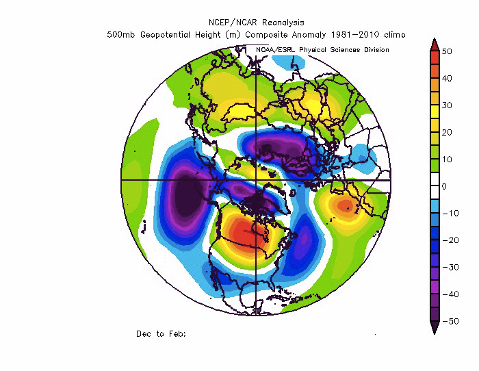
Our analog composite for the DJF period during the upcoming winter. Yes, we hid the years that we used.
What we’ve decided to play around with is a more detailed “weighting” of analog years. Basically, we decided to take our best analog year and weight it more than the second best, which is weighted slightly more than the third best, etc. This provides us with a bit more confidence that our analogs could at least reasonably reflect what we expect going forward.
We hit a bit of a breakthrough yesterday when we realized that our weighted analog composite actually matches very well to the ongoing pattern in October – and the ideas rolled forward into November make a lot of sense as well. So we’ve gained a lot of confidence in our ideas for the winter, especially December, January and February as a whole. We’re only three weeks or so away from the Winter Forecast being completed (orders another espresso).
Anyway, that’s all i’ve got for today. We’ll have more “official” stuff coming this week with details on 91L and new stuff from the Winter Forecast. Enjoy the rest of your Saturday, and Lets Go Yankees (please win this game).
Leave a Reply
Want to join the discussion?Feel free to contribute!