-2")
NYC Area Forecast: Colder, active pattern arrives late week
After a very warm start to Autumn, which featured temperature several degrees above normal essentially from late September through the middle of October, the weather pattern is set to change. You can thank the North Pacific Ocean for that – while just one of many factors responsible, it is a big one – as the large scale wave pattern (ridges, troughs, etc) is changing dramatically there. Eventually, these changes make their way toward the Lower 48.
Most notably, a large ridge is forecast to develop from the Pacific Northwest into British Columbia and other parts of Western Canada. The poleward reach of this ridge will be impressive and quite anomalous, with 500hPa (mid level) atmospheric heights running well above normal. As this ridge pushes northward, it will disrupt the higher latitude weather pattern, sending colder air surging further southward into Eastern Canada, the Great Lakes and Northeast.
Multiple areas of anomalous ridging will build into British Columbia over the next 14 days – and they will keep cooler than normal air flowing into the Northeast/Great Lakes. This synoptic pattern will also result in the threat for storminess in the Eastern US to end October. pic.twitter.com/coD8UQ27ju
— John Homenuk (@jhomenuk) October 15, 2018
The first in a series of ridges is already in the process of establishing itself there. Colder than normal air has already surged southward into the Plains States and the Midwest United States, with temperatures over the next few days forecast to run 15 to 25 degrees below normal over a very large area. The National Weather Service is forecasting widespread record low maximum temperatures and record low minimum temperatures from Texas and the Intermountain West into the Great Lakes region.
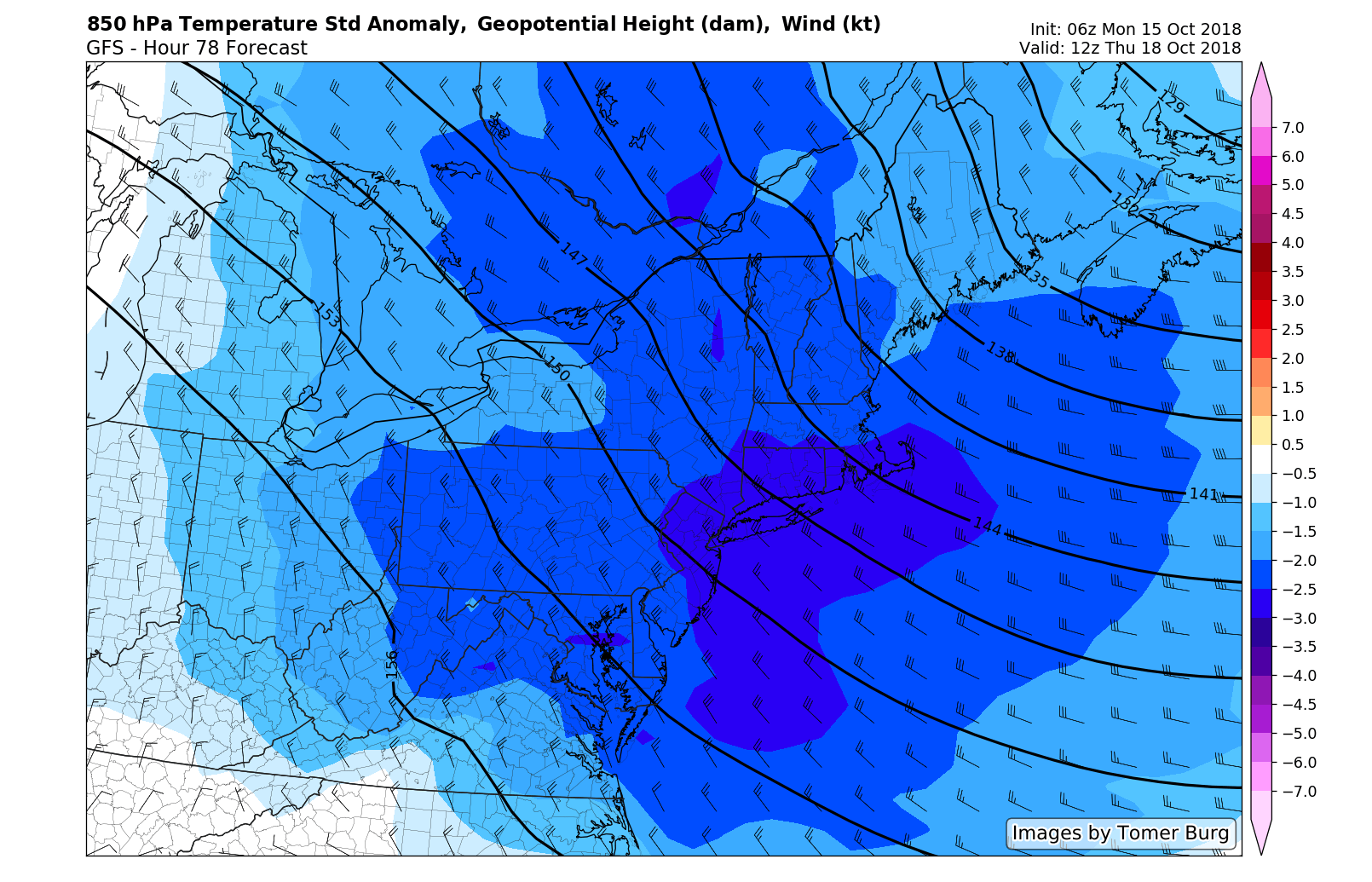
This cold air will move eastward with time, but will be further exacerbated by the building ridge over British Columbia. Forecast models suggest that a trough will dig southward into New England later this week – approaching the outer periphery of climatological heights. In other words, the 500hPa trough will be deeper and more impressive than most which have been observed in New England for this time of year. Temperatures in the mid and low levels of the atmosphere will also be anomalous – with temperatures well below normal in New England and even parts of the Mid Atlantic from Thursday into Friday.
In fact, late this week may serve as the first opportunity for a hard freeze for many parts of New England that have not seen it yet. 850hPa temperatures are expected to run below -15 C in many regions, with a northwest flow in the wake of a deep trough. Additional ridging will begin developing over British Columbia essentially through the next 14 days, opening the door for a parade of troughs to surge into Southeast Canada, the Great Lakes and the Northeast states. Temperatures should run well below normal on average through the end of October.
In addition to the deep, anomalous and persistent troughing will come the threat for storminess in the Eastern USA toward the end of the month. Anomalous ridging into British Columbia and multiple disturbances surging southward into the USA suggests the potential for one or more storm systems, especially during the time period centered around 10/25.
The European Ensemble continues to suggest this potential, with a notable reversal in MSLP trends from high pressure to low pressure along the East Coast during this time. It remains to be seen exactly how and when any threat will evolve – and how significant it will be – but the synoptic pattern certainly argues for the potential.
We will, of course, have further updates on the pattern and any potential storms as we draw closer. For now, enjoy the rest of your Monday!
Great read as always