-2")
The Importance of the Stratosphere
The behavior of the stratosphere will become increasingly important in the next 15 to 30 days. Our best understanding of the current conditions and forecast evolution suggest that the stratosphere may aid in the development of colder and wintry conditions by late December in the Northeast US.
Winter has gotten off to a fast start. After an early November snowstorm (and transportation disaster) in the Northern Mid-Atlantic, the pattern has been steadily colder than normal. A major winter storm impacted the Lower Mid-Atlantic this week, with 1 to 2 feet of snowfall over parts of Virginia and North Carolina. After almost a month of wintry conditions, including one of the fastest starts ever for the ski regions of Vermont, the pattern finally looks likely to take a hiatus as moderating temperatures approach this weekend.
You can thank a retreating polar vortex and an extending Pacific Jet stream for that – the weather pattern is likely to moderate as maritime, Pacific air starts to grab a stranglehold on the weather across the United States. With the polar vortex vacating Canada and heading into Eurasia, wintry weather chances should be few and far between until Christmas. The change, however, will be short lived and the vacating of the polar vortex itself is a harbinger of things to come. A climate phenomena driving the changes back towards a colder and wintry pattern – a Sudden Stratospheric Warming event – is already in the infant stages of developing.
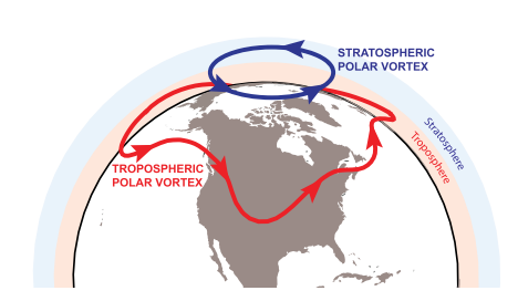
What is the stratospheric polar vortex, exactly?
The stratosphere, while not part of the direct/sensible weather we observe every day, has an important role in the forecast. You probably are familiar with the term “polar vortex” – but in meteorology, this term is actually used to describe the planetary circumpolar vortex. The polar vortex discussed in news media is more often referencing the tropospheric polar vortex, or the part of the polar vortex that directly impacts our weather. The stratospheric polar vortex exists at its most notable strength from Autumn to the end of Winter, and is much smaller in size than the polar vortex in the troposphere.. The vortex is most often defined via areas of higher potential vorticity (PV). (Wagh, Sobel, Polvani 2016).
While seemingly disconnected from our weather, the stratospheric polar vortex is quite important. While a separate entity from the polar vortex that impacts our weather on a direct basis, its strength and positioning can have major implications on our weather. The stratosphere and troposphere often work together, especially when they are directly coupled, and changes in the strength and positioning of the stratospheric polar vortex can lead to major changes in the troposphere as well.
Polar Vortex Comparison, Darryn W. Waugh, Adam H. Sobel, and Lorenzo M. Polvani, 2016.
One of the more significant events that we monitor are Sudden Stratospheric Warming events, or SSW’s. These occur when the stratospheric polar vortex is suddenly disrupted by major warmth – and splits or fractures into multiple pieces. There are also often displacements and disruptions of the stratospheric polar vortex, led by warming at the arctic regions and the North Pole. Both of these types of events can lead to tropospheric impacts and direct impacts on our weather down the road.
In general, Sudden Stratospheric Warming events, or “SSW’s” can lead to arctic outbreaks and a propensity for winter storms to develop in the United States. From a simple standpoint, the rising heights in the stratosphere make it easier for high latitude blocking to develop in the troposphere. With high latitude blocking developing in areas like Canada and the Arctic, cold air is displaced southward into Canada and the United States, and the weather pattern becomes amplified and anomalous. Chances for a SSW appear to be increasing from late December and January, as heat flux increases in the stratosphere and tropospheric forcing from cyclonic and anti-cyclonic wave-breaking events occurs.
These SSW events feature a very large increase in temperatures in the stratosphere around 10hpa (that’s way up there!) with a reversal of zonal winds from westerly to easterly in the high-latitudes between 60N and 90N. However, while they can have long-lasting impacts for the remainder of the winter, a Sudden Stratosphere Warming event — as officially defined– is not really needed in order to cause major changes in our weather pattern.
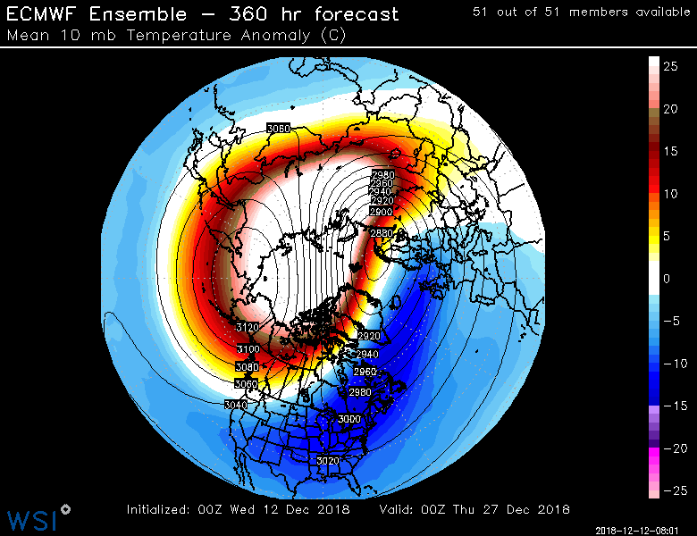
The ECMWF EPS forecasting significant stratospheric warming at 10mb occurring over much Siberia in late December
The changes in the stratosphere are already well underway. Models are in good agreement that there will be a notable stratospheric warming event with decreasing zonal winds in the stratosphere by the middle of December. This will lead to a major displacement of stratospheric polar vortex, largely pushing the vortex over Eurasia with a strong Aleutian high moving over Alaska/British Columbia. The troposphere will largely be coupled with the stratosphere, which will help to develop a poleward -EPO ridge, with a cross-polar flow becoming established over Canada and parts of the United States by 12/25.
At first, there will be some resistance to the movement of the cold air. A -AAM (Atmospheric Angular Momentum) is strongly favored, which correlates well to a Southeast Ridge anomaly. The cold air during this time frame may also be modified by some residual warmer air over much Canada, but a Pacific jet retraction is also favored after 12/25 – with heights building in to Greenland. The Pacific Jet retreating into the Central Pacific is an important part of the forecast. This will cause an increase in heating demand in key demand regions over the Central and Eastern US, with GWHDD numbers likely to begin rising above 30-year climatological averages after 12/25.
Many models and ensembles are suggesting an even larger stratospheric warming event near Christmas, with zonal winds reversing to easterly. If the suggestion is correct, it could lead to further weakening of the stratospheric polar vortex and thus result in more high-latitude blocking in the AO/NAO regions and perhaps a more severe arctic cold outbreak in much of the country.
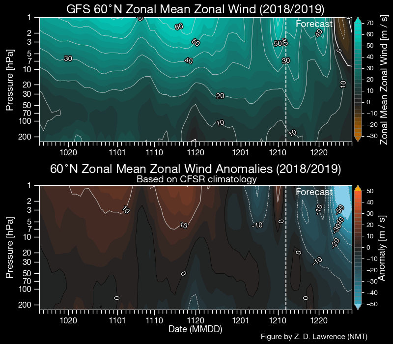
The GFS model forecasting zonal wind anomalies at 60N to decrease significantly in all levels of the stratosphere closer to Christmas
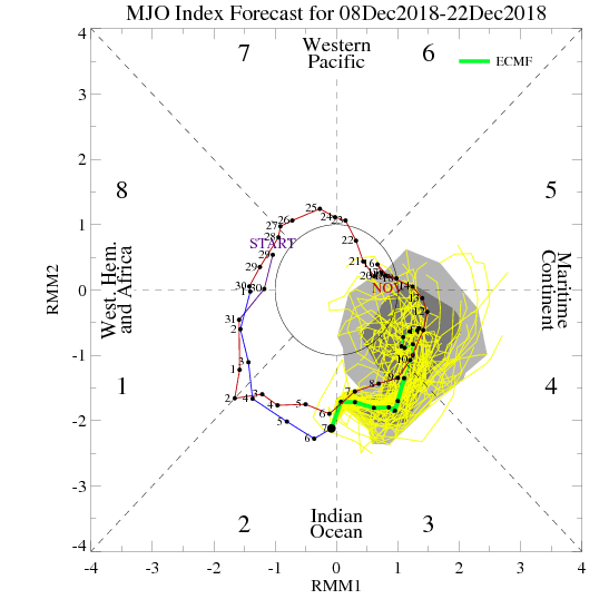
While we anticipate that the late December pattern will eventually evolve into colder one for much the Central and Eastern US, there will be some likely warmth during the transition and as the pattern reshuffles – there are also a few indeterminate factors during the longer range, icnluding the MJO. The ECMWF EPS is now also in better agreement with the GEFS forecasting the MJO to weaken later in the month. This adds confidence in a trough over the Aleutians with a building ridge over British Columbia and Western North America.
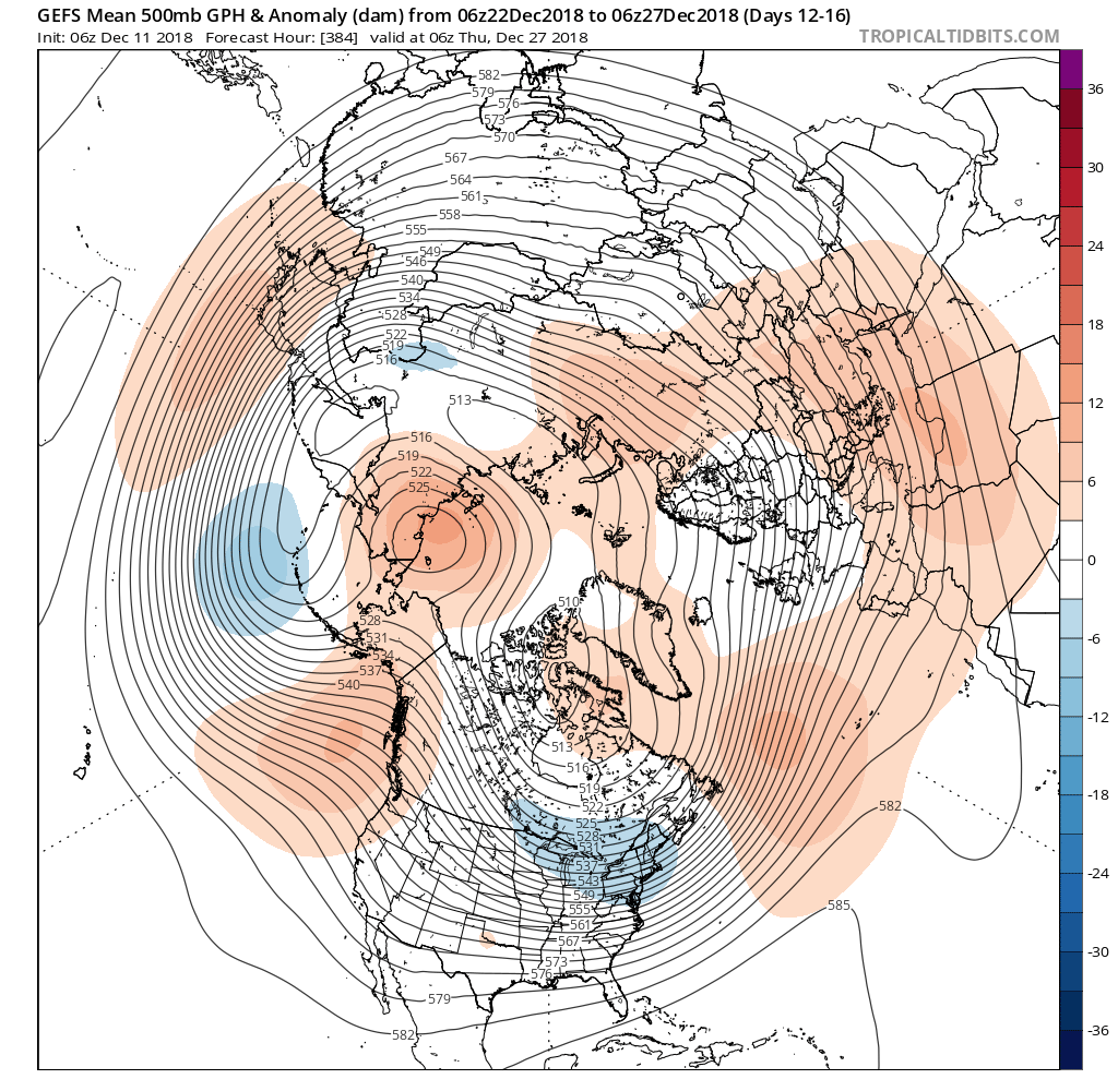
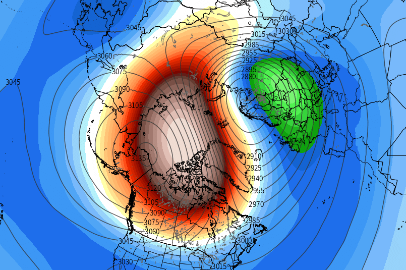
The GEFS showing the -EPO ridge closer to British Columbia with heights building into Alaska and the Arctic regions. This may help establish a cross-polar flow with lower heights and colder temperatures over much of the Central and Eastern US, between 12/22/18 to 12/27/18.
Our forecast thoughts continue to evolve in late December, but confidence is rising that after a period of warmth in the middle of the month, likely continuing until around 12/20 or so, the risks for cold and stormy weather will return. The reemergence of high latitude blocking, a retracting and poleward reaching Pacific Jet, and a continually disturbed stratospheric vortex are all major factors in the forecast.
Overall, we expect wintry and colder weather will return to the Northeast states gradually from 12/25 onward, perhaps reaching a gradual crescendo into the first and second weeks of January. More details to come in the coming days. If you’re looking for more detailed posts like this every day, plus videos and consulting options, sign up for our Long Range Energy/Agriculture services.
Article compiled by Miguel Pierre and John Homenuk. Model images and graphics sourced from WSI, WeatherBell Analytics, and StratObserve.com. Additional references from images obtained from “What is the Polar Vortex and How Does It Impact Weather?”; Darryn W. Waugh, Adam H. Sobel, and Lorenzo M. Polvani, 2016.
Leave a Reply
Want to join the discussion?Feel free to contribute!