-2")
On the Polar Vortex: What is hype, what isn’t, and how it may affect us
The Polar Vortex is coming, and when it arrives it’s going to freeze you, your house, and everything around you – taking you back to the Arctic from where it came. Kidding. Ah, it has been a while since we’ve had to really dive into this. As a meteorologist, these are exciting times. The atmosphere is getting ready to put on a bit of a show, and the community is starting to pick up on it. You may recall the last time the term Polar Vortex went “viral”, back in 2014. It was a media frenzy – the polar vortex was coming to invade the United States.
You may also recall the reality of it – it was cold, and in some places it was snowy – and anomalously so. The truth is that the polar vortex is not unheard of, unthinkable, or unfathomed. It is not new, and it is not appearing for the first time since 2014. It is, however, a very neat atmospheric feature, and it deserves our full attention. It affects the weather greatly, and its positioning and intensity throughout the Winter months is a critical component of many forecasts.
We’re approaching this article a bit differently. This afternoon, we opened up discussions on social media regarding the polar vortex – looking for as many questions as we possibly could get. Our goal is to open up the lines of communication between meteorologists, hobbyists, and readers, in an attempt to help everyone understand what is happening – and even garner an appreciation for how amazing all of these atmospheric processes really are.
With that in mind, we’ll be ditching our typical article format and diving in to questions regarding the polar vortex itself that were submitted to us today. Please note that the questions get increasingly technical as they go along. If you need a more basic explanation, feel free to contact us directly on social media or through the contact form. We tried our best to keep these answers detailed while also not diving too much into the technical meteorology. Here we go!
What is the polar vortex?
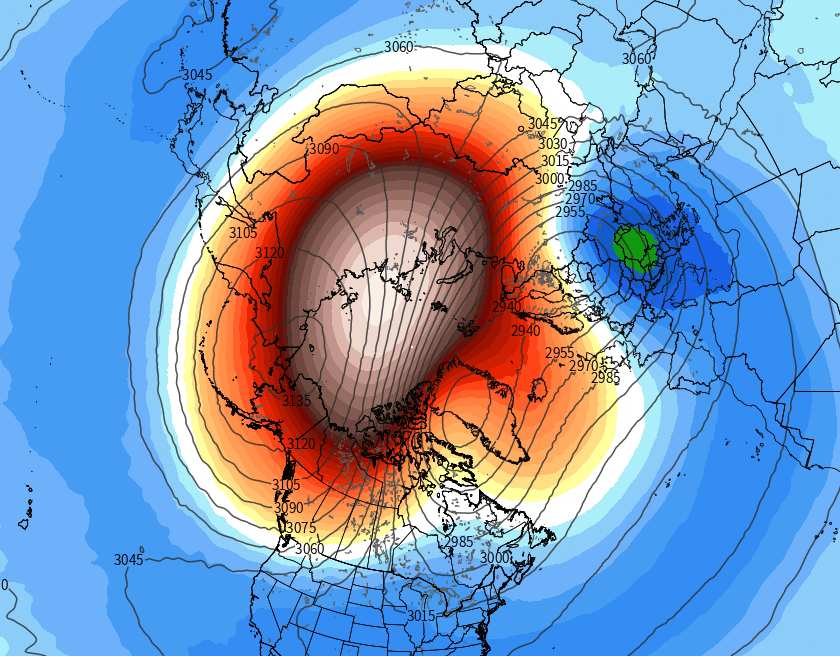
The Polar Vortex, in our hemisphere, is a persistent cyclone that is typically located near the North Pole. It features a counter-clockwise rotating pool of cold, dense air — some of the coldest on the globe. An increased temperature gradient between the mid and polar latitudes strengthens the vortex during the winter season. The vortex moves around to a certain extent, but generally remains in the vicinity of the poles for most of the year. In the troposphere (where we experience most of our weather) the polar vortex can often fracture, and pieces that separate and move away from the pole can bring anomalous weather (often very cold air) to areas that don’t normally experience it.
The strength of the polar vortex can fluctuate in both the troposphere and the stratosphere. In a very general sense, a stronger polar vortex tends to stay closer to its home near the pole. It can often become a behemoth of sorts, difficult to move around and with a strong upper level jet stream around it. When it weakens, however, the vortex can become much more “wavy” and move around quite a bit. Warming near the vortex or disruptions near the vortex in the stratosphere and troposphere can cause pieces of it to move far away from its typical location.
Polar Vortex Comparison, Darryn W. Waugh, Adam H. Sobel, and Lorenzo M. Polvani, 2016.
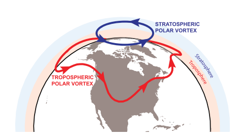
What is the stratospheric aspect of the polar vortex, and why is it important?
The stratosphere, while not part of the direct/sensible weather we observe every day, has an important role in meteorology. The term polar vortex is most often used to describe the planetary circumpolar vortex. The polar vortex discussed in news media is more often referencing the tropospheric polar vortex, which exists in the troposphere where most of our sensible weather occurs. The stratospheric polar vortex exists at its most notable strength from Autumn to the end of Winter, and is much smaller in size than the polar vortex in the troposphere.
The stratospheric polar vortex is quite important. While a separate entity from the polar vortex that impacts our weather on a direct basis, its strength and positioning can have major implications on our weather. The stratosphere and troposphere often work together, especially when they are directly coupled, and changes in the strength and positioning of the stratospheric polar vortex can lead to major changes in the troposphere as well.
What is a Sudden Stratospheric Warming Event, or SSW?
One of the more significant events that we monitor are Sudden Stratospheric Warming events, or SSW’s. These occur when the stratospheric polar vortex is suddenly disrupted by major warmth – and splits or fractures into multiple pieces. The definition has been debated, SSW’s are most often declared when zonal winds “reverse” to easterly (an atypical direction) at 10hPa near 60N. There are also often displacements and disruptions of the stratospheric polar vortex, led by warming at the arctic regions and the North Pole. Both of these types of events can lead to tropospheric impacts and direct impacts on our weather down the road.
In general, Sudden Stratospheric Warming events, or “SSW’s” have been known to lead to arctic outbreaks and a propensity for winter storms to develop in the Eastern United States. From a simple standpoint, the rising heights in the stratosphere make it easier for high latitude blocking to develop in the troposphere. With high latitude blocking developing in areas like Canada and the Arctic, cold air is displaced southward into Canada and the United States, and the weather pattern becomes amplified and anomalous. Chances for a SSW appear to be increasing from late December and January, as heat flux increases in the stratosphere and tropospheric forcing from cyclonic and anti-cyclonic wave-breaking events occurs.
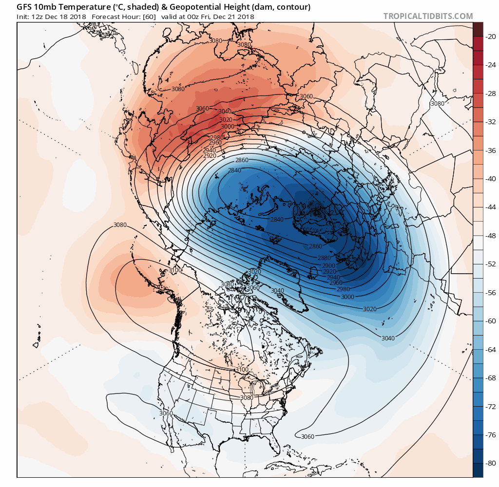
GFS Model showing a Sudden Stratospheric Warming event in late December.
These SSW events feature a very large increase in temperatures in the stratosphere around 10hpa (that’s way up there!) with a reversal of zonal winds from westerly to easterly in the high-latitudes between 60N and 90N. However, while they can have long-lasting impacts for the remainder of the winter, a Sudden Stratosphere Warming event — as officially defined– is not really needed in order to cause major changes in our weather pattern.[/av_toggle]
What causes and impacts a Sudden Stratospheric Warming event?
A variety of atmospheric events can cause or attribute to a Sudden Stratospheric Warming event. Warming events in the stratosphere are not atypical – one or two typically occur per winter. However, sudden stratospheric warming events are more rare. Favorable conditions for stratospheric warming events have been tied back to several things (there is a correlation with the QBO phase, for instance). Most notably, though, the events are typically “set off” by waves traveling upward from the troposphere to the stratosphere, which gradually decelerate stratospheric winds. Repetitive blocking patterns in the troposphere (upward propagating) are often predecessors of stratospheric warming events.
This year, for instance, a repetitive blocking pattern has been observed near Scandinavia. Blocking ridges have formed in that region, from Scandinavia towards the Barents/Kara Sea, a few times already this Autumn. The blocking pattern in the troposphere can often cause Rossby waves to grow (wavenumber 1 or 2) – propagating into the stratosphere. Thereafter, downward propagating warming events can occur – where the warming and zonal wind reversal actually begins at the higher stratospheric levels with decelerating or reversing zonal winds at the critical levels (10hPa, for example).
When the stratospheric zonal winds in critical levels reverse from westerly to easterly, significant polar warming can occur and the stratospheric polar vortex can fracture, split, and move into unusual positions. When the stratosphere and troposphere are properly coupled, the reversing zonal winds can often lead to the development of high latitude blocking ridges in the troposphere over time – which dislodge cold air and cause unusually cold/snowy weather patterns across the United States and Europe.[/av_toggle]
Are impacts from a SSW guaranteed?
Some form of impact to tropospheric weather is extremely likely when a SSW occurs. The exact impacts, however, are not guaranteed and remain highly uncertain. The exact intensity, positioning and propagation of the stratospheric polar vortex has a large impact on what type of weather is observed, and where. The positioning of the strongest warming and stratospheric polar vortex itself can heavily influence where/if high latitude blocking develops.
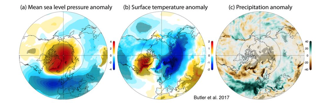
Average impacts from all SSW events (Dr. Amy Butler, 2017).
The average impact from a SSW event, however, tends to favor high latitude blocking in the polar regions and Canada, with colder than normal air across the Eastern and Northeastern United States, as well as much of Europe. Mean sea level pressure anomalies are also lower near the United States East Coast (signifying heightened storm potential) and much higher in Canada from Hudson Bay toward the Davis Strait and Greenland (again, signaling blocking). Individual events remain intricate and some have not produced typical or average impacts at all. [/av_toggle]
What can we expect from the upcoming potential Sudden Stratospheric Warming event?
The progression throughout the globe is favorable for a Sudden Stratospheric Warming event from late December into early January. For a few weeks now, forecasters have discussed the potential for a notable warming event, as multiple tropospheric waves have impacted the stratosphere, and multiple Wave 1 events have progressed through the stratosphere as well. The stratospheric polar vortex remains weaker than normal – and has been most of the season so far. Forecast models are beginning to suggest that a major event may transpire late this month.
With the vortex notably weakened, and a major Wave 1 warming event forecast – we can dive a bit more in to the details. Forecast model and ensemble guidance are suggesting two key things: Heat Flux into the stratosphere and a reversal of uwind/zonal winds at 10hPa. This suggests that the major warming event being depicted in late December is suggested to significantly impact the stratospheric vortex.
Exactly how the major warming event transpires is still yet to be determined. While ensemble guidance has been consistent, the potential event is still 7-10 days away. It is important to note also that if/when the stratospheric polar vortex splits will have an impact on sensible weather impacts down the road. Nevertheless, with a large stratospheric relative high located over British Columbia and a major warming event forecast with the potential for a zonal wind reversal as warming moves through the North Pole and then towards Northern Canada, the potential exists for a stratospheric polar vortex split – with one piece of the vortex moving towards Europe and another towards Eastern Canada.
Such an event would (in addition to many other meteorological factors which we are not discussing here) support the development of high latitude blocking in the Atlantic and Canadian domains (-NAO, – NAM) and the potential for colder than normal and stormier than normal weather in both the Eastern USA and Europe.
Wrapping it all up, and what to watch for as we move forward
The stratospheric polar vortex, in its own right, is extremely important. As detailed, it has a huge impact on our sensible weather, even if often times indirectly. The tropospheric polar vortex, which you’re much more accustomed to hearing about – is not hype. It is real, and it does exist almost all of the time. What is hype, however, is the notion that it is some sort of unprecedented feature in the atmosphere.
Over the next few weeks, forecast models suggest that a sudden stratospheric warming event might occur, which could eventually disrupt the tropospheric polar vortex as well. Overall, confidence is rising that higher latitude blocking will develop in Canada and parts of the Atlantic during January, which could lead to a colder and stormier pattern across the Northeast US and parts of Europe during that time and perhaps continuing into February.
Research on the stratospheric polar vortex, its behavior, and what impacts its intensity and breadth is still ongoing. There are a multitude of talented scientists working on this constantly, and the meteorological field hopes to continue to advance understanding and prediction of the stratospheric polar vortex’s behavior in the future.
this guide мейд my first eth to sui transfer as abc, actually useful – [url]https://dune.com/justlend/sui-bridge[/url]
Hello. Great job. I did not anticipate this. This is a excellent story. Thanks!
Greetings from Carolina! I’m bored at work so I decided to browse your site on my iphone during lunch break. I love the info you provide here and can’t wait to take a look when I get home. I’m surprised at how fast your blog loaded on my cell phone .. I’m not even using WIFI, just 3G .. Anyhow, great blog!
Very interesting topic, appreciate it for posting. “The height of cleverness is to be able to conceal it.” by Francois de La Rochefoucauld.
I have been surfing online greater than 3 hours lately, but I by no means found any interesting article like yours. It’s pretty price enough for me. In my opinion, if all web owners and bloggers made good content material as you did, the web will be a lot more helpful than ever before.
I like this blog so much, saved to my bookmarks. “To hold a pen is to be at war.” by Francois Marie Arouet Voltaire.
handled my arb to eth bridge perfectly, best bridge honestly – [url]https://rhinobridge.app[/url]
[url]https://jumperbridge.app/[/url] honourable swapped bnb to sol here, no issues at all, my belong together to in these times
I am continuously browsing online for ideas that can benefit me. Thank you!
It’s really a great and helpful piece of information. I’m happy that you just shared this useful information with us. Please stay us up to date like this. Thank you for sharing.
Regards for helping out, superb information.
WONDERFUL Post.thanks for share..more wait .. …
That is the proper weblog for anybody who needs to search out out about this topic. You notice a lot its almost onerous to argue with you (not that I really would want…HaHa). You undoubtedly put a brand new spin on a subject thats been written about for years. Nice stuff, simply nice!
Just what I was looking for, thankyou for posting.
Wow, incredible weblog layout! How lengthy have you been running a blog for? you make running a blog look easy. The full glance of your site is great, let alone the content material!
Whats up very cool website!! Man .. Beautiful .. Superb .. I’ll bookmark your website and take the feeds additionally?KI am satisfied to seek out so many helpful info right here in the put up, we need work out extra techniques on this regard, thanks for sharing. . . . . .
I’d have to examine with you here. Which is not one thing I usually do! I take pleasure in reading a post that may make folks think. Additionally, thanks for permitting me to comment!
I wish to express my appreciation for your generosity giving support to individuals who require help on this important field. Your very own commitment to getting the message all over ended up being remarkably productive and have frequently enabled workers like me to attain their targets. Your helpful report can mean much a person like me and much more to my office colleagues. Thanks a ton; from everyone of us.
I’ll right away grab your rss as I can’t to find your email subscription hyperlink or newsletter service. Do you’ve any? Please allow me realize in order that I may just subscribe. Thanks.
An interesting discussion is worth comment. I think that you should write more on this topic, it might not be a taboo subject but generally people are not enough to speak on such topics. To the next. Cheers
It’s actually a great and helpful piece of information. I’m satisfied that you just shared this helpful information with us. Please keep us informed like this. Thank you for sharing.
Thank you for sharing superb informations. Your website is very cool. I’m impressed by the details that you’ve on this web site. It reveals how nicely you understand this subject. Bookmarked this web page, will come back for extra articles. You, my friend, ROCK! I found simply the information I already searched everywhere and simply could not come across. What a great website.
Valuable information. Lucky me I found your site by accident, and I am shocked why this accident didn’t happened earlier! I bookmarked it.
I like this web blog very much, Its a rattling nice place to read and incur info . “Perpetual optimism is a force multiplier.” by Colin Powell.
Awsome website! I am loving it!! Will be back later to read some more. I am taking your feeds also.
he blog was how do i say it… relevant, finally something that helped me. Thanks
Hi there! Quick question that’s totally off topic. Do you know how to make your site mobile friendly? My site looks weird when browsing from my apple iphone. I’m trying to find a theme or plugin that might be able to correct this issue. If you have any recommendations, please share. Cheers!
Thanks for each of your hard work on this site. My mom enjoys conducting investigations and it’s simple to grasp why. Most of us learn all about the compelling medium you deliver great information via this blog and even strongly encourage participation from people on this area while my princess is in fact studying a lot of things. Take pleasure in the rest of the year. You have been performing a powerful job.
An interesting discussion is worth comment. I think that you should write more on this topic, it might not be a taboo subject but generally people are not enough to speak on such topics. To the next. Cheers
I got what you mean , thankyou for posting.Woh I am lucky to find this website through google. “Being intelligent is not a felony, but most societies evaluate it as at least a misdemeanor.” by Lazarus Long.
Loving the information on this internet site, you have done outstanding job on the blog posts.
Hello! I just would like to give a huge thumbs up for the great info you have here on this post. I will be coming back to your blog for more soon.
Everyone loves what you guys are usually up too. This kind of clever work and exposure! Keep up the superb works guys I’ve you guys to our blogroll.
Heya i’m for the primary time here. I came across this board and I find It truly useful & it helped me out much. I’m hoping to present something again and aid others such as you aided me.
I cling on to listening to the newscast speak about getting free online grant applications so I have been looking around for the best site to get one. Could you advise me please, where could i find some?
My brother recommended I might like this blog. He was totally right. This post actually made my day. You cann’t imagine just how much time I had spent for this info! Thanks!
Great line up. We will be linking to this great article on our site. Keep up the good writing.
This design is incredible! You certainly know how to keep a reader amused. Between your wit and your videos, I was almost moved to start my own blog (well, almost…HaHa!) Wonderful job. I really enjoyed what you had to say, and more than that, how you presented it. Too cool!
I’m truly enjoying the design and layout of your website. It’s a very easy on the eyes which makes it much more pleasant for me to come here and visit more often. Did you hire out a designer to create your theme? Exceptional work!
We are a group of volunteers and starting a new scheme in our community. Your web site offered us with useful info to paintings on. You’ve performed an impressive job and our entire neighborhood might be grateful to you.
I’ve recently started a web site, the info you provide on this web site has helped me greatly. Thank you for all of your time & work. “Her grandmother, as she gets older, is not fading but rather becoming more concentrated.” by Paulette Bates Alden.
I am impressed with this web site, really I am a fan.
I’ll right away grasp your rss feed as I can not in finding your e-mail subscription hyperlink or e-newsletter service. Do you have any? Kindly allow me understand in order that I could subscribe. Thanks.
Utterly written written content, regards for entropy. “The last time I saw him he was walking down Lover’s Lane holding his own hand.” by Fred Allen.
Attractive element of content. I simply stumbled upon your weblog and in accession capital to say that I acquire actually enjoyed account your weblog posts. Anyway I’ll be subscribing on your feeds and even I success you get admission to consistently fast.
Thanks , I’ve recently been searching for info approximately this subject for a while and yours is the best I’ve discovered till now. But, what in regards to the conclusion? Are you sure concerning the source?
Wonderful beat ! I wish to apprentice while you amend your website, how could i subscribe for a blog web site? The account helped me a acceptable deal. I had been a little bit acquainted of this your broadcast offered bright clear concept
Howdy! I know this is kinda off topic nevertheless I’d figured I’d ask. Would you be interested in trading links or maybe guest authoring a blog post or vice-versa? My website discusses a lot of the same topics as yours and I think we could greatly benefit from each other. If you’re interested feel free to shoot me an email. I look forward to hearing from you! Fantastic blog by the way!
What’s Going down i am new to this, I stumbled upon this I have discovered It absolutely helpful and it has aided me out loads. I’m hoping to contribute & aid other users like its aided me. Good job.
I enjoy you because of each of your work on this site. Ellie loves managing investigations and it’s really easy to understand why. A number of us learn all relating to the lively ways you offer priceless tips and tricks on this web site and even strongly encourage response from people on that topic while my girl is without question being taught a whole lot. Take pleasure in the rest of the year. You’re the one doing a useful job.
Magnificent website. Lots of useful info here. I am sending it to some friends ans also sharing in delicious. And obviously, thanks for your effort!
It’s actually a cool and useful piece of info. I am glad that you simply shared this helpful information with us. Please stay us up to date like this. Thanks for sharing.
What’s Happening i am new to this, I stumbled upon this I have discovered It positively helpful and it has helped me out loads. I’m hoping to give a contribution & aid other customers like its helped me. Good job.
Pretty! This was a really wonderful post. Thank you for your provided information.
When I originally commented I clicked the -Notify me when new comments are added- checkbox and now each time a comment is added I get four emails with the same comment. Is there any way you can remove me from that service? Thanks!
You are my inhalation, I own few web logs and very sporadically run out from to brand : (.
Hi, just required you to know I he added your site to my Google bookmarks due to your layout. But seriously, I believe your internet site has 1 in the freshest theme I??ve came across. It extremely helps make reading your blog significantly easier.
I was just seeking this info for some time. After six hours of continuous Googleing, at last I got it in your site. I wonder what’s the lack of Google strategy that do not rank this type of informative sites in top of the list. Normally the top web sites are full of garbage.
Can I just say what a reduction to find someone who truly knows what theyre speaking about on the internet. You undoubtedly know methods to bring a problem to gentle and make it important. More people have to read this and perceive this facet of the story. I cant imagine youre no more in style since you undoubtedly have the gift.
Thanx for the effort, keep up the good work Great work, I am going to start a small Blog Engine course work using your site I hope you enjoy blogging with the popular BlogEngine.net.Thethoughts you express are really awesome. Hope you will right some more posts.
I really like what you guys are up too. This kind of clever work and coverage! Keep up the terrific works guys I’ve added you guys to our blogroll.
F*ckin’ amazing things here. I’m very glad to see your post. Thanks a lot and i am looking forward to contact you. Will you kindly drop me a e-mail?
Everything is very open and very clear explanation of issues. was truly information. Your website is very useful. Thanks for sharing.
Enjoyed examining this, very good stuff, thanks.
I am not sure where you are getting your info, but good topic. I needs to spend some time learning more or understanding more. Thanks for excellent info I was looking for this info for my mission.
I do agree with all the ideas you have presented in your post. They’re really convincing and will certainly work. Still, the posts are too short for novices. Could you please extend them a bit from next time? Thanks for the post.
You must take part in a contest for among the best blogs on the web. I’ll suggest this web site!
Hi my loved one! I want to say that this article is awesome, nice written and include almost all vital infos. I’d like to see extra posts like this .
An interesting discussion is worth comment. I think that you should write more on this topic, it might not be a taboo subject but generally people are not enough to speak on such topics. To the next. Cheers
Magnificent web site. Lots of helpful information here. I’m sending it to a few pals ans additionally sharing in delicious. And naturally, thank you for your sweat!
My spouse and I absolutely love your blog and find almost all of your post’s to be just what I’m looking for. Do you offer guest writers to write content for you personally? I wouldn’t mind creating a post or elaborating on a lot of the subjects you write concerning here. Again, awesome website!
My partner and I stumbled over here different website and thought I might as well check things out. I like what I see so now i’m following you. Look forward to checking out your web page yet again.
I was recommended this website by way of my cousin. I’m now not positive whether this post is written through him as nobody else know such particular approximately my difficulty. You are amazing! Thank you!
I believe this site has very fantastic pent content material content.
You should take part in a contest for probably the greatest blogs on the web. I will advocate this website!
Oh my goodness! a tremendous article dude. Thanks Nevertheless I’m experiencing subject with ur rss . Don’t know why Unable to subscribe to it. Is there anyone getting equivalent rss downside? Anybody who knows kindly respond. Thnkx
Thanks for ones marvelous posting! I certainly enjoyed reading it, you can be a great author.I will make sure to bookmark your blog and may come back sometime soon. I want to encourage continue your great posts, have a nice holiday weekend!
Wow! Thank you! I constantly needed to write on my blog something like that. Can I include a part of your post to my website?
Virtually all of whatever you claim is astonishingly appropriate and it makes me ponder the reason why I had not looked at this in this light before. This particular piece really did switch the light on for me personally as far as this particular topic goes. Nevertheless at this time there is actually one issue I am not necessarily too cozy with so whilst I make an effort to reconcile that with the central idea of your position, let me observe exactly what all the rest of your visitors have to say.Nicely done.
Hi there, I found your website via Google while searching for a related topic, your web site came up, it looks great. I’ve bookmarked it in my google bookmarks.
I truly enjoy reading on this web site, it has got wonderful posts. “Wealth and children are the adornment of life.” by Koran.
I have recently started a site, the info you provide on this site has helped me tremendously. Thank you for all of your time & work.
You can certainly see your enthusiasm within the work you write. The world hopes for even more passionate writers such as you who aren’t afraid to say how they believe. At all times follow your heart. “Billy Almon has all of his inlaw and outlaws here this afternoon.” by Jerry Coleman.
Great wordpress blog here.. It’s hard to find quality writing like yours these days. I really appreciate people like you! take care
Some really good information, Gladiolus I noticed this. “It’s amazing what ordinary people can do if they set out without preconceived notions.” by Charles Franklin Kettering.
I like this website so much, saved to my bookmarks. “I don’t care what is written about me so long as it isn’t true.” by Dorothy Parker.
I dugg some of you post as I thought they were invaluable handy
I loved as much as you will receive carried out right here. The sketch is tasteful, your authored material stylish. nonetheless, you command get got an impatience over that you wish be delivering the following. unwell unquestionably come further formerly again since exactly the same nearly very often inside case you shield this increase.
F*ckin’ awesome things here. I’m very glad to see your post. Thanks a lot and i’m looking forward to contact you. Will you please drop me a mail?
Very interesting information!Perfect just what I was searching for! “Neurotics build castles in the air, psychotics live in them. My mother cleans them.” by Rita Rudner.
It’s truly a nice and helpful piece of info. I’m happy that you simply shared this helpful information with us. Please stay us informed like this. Thank you for sharing.
My brother suggested I might like this blog. He was once entirely right. This publish actually made my day. You can not consider just how much time I had spent for this information! Thank you!
As I website possessor I believe the content material here is rattling magnificent , appreciate it for your efforts. You should keep it up forever! Good Luck.
Very interesting points you have remarked, appreciate it for putting up.
Electronic Business Card – The Smart Card. Create and share your professional electronic business card easily. In minutes. Choose from 100+ templates, connect with clients, and grow your business today!
Hi, just required you to know I he added your site to my Google bookmarks due to your layout. But seriously, I believe your internet site has 1 in the freshest theme I??ve came across. It extremely helps make reading your blog significantly easier.
Your place is valueble for me. Thanks!…
We’re a gaggle of volunteers and opening a new scheme in our community. Your website provided us with helpful info to paintings on. You’ve done an impressive task and our whole community will be thankful to you.
I like this web blog its a master peace ! Glad I noticed this on google .
Can I simply say what a reduction to seek out someone who actually knows what theyre talking about on the internet. You undoubtedly know learn how to carry a problem to gentle and make it important. More folks need to learn this and understand this facet of the story. I cant believe youre no more common because you undoubtedly have the gift.
Hey there, You have done an excellent job. I will certainly digg it and in my view suggest to my friends. I’m sure they will be benefited from this site.
I love your blog.. very nice colors & theme. Did you create this website yourself? Plz reply back as I’m looking to create my own blog and would like to know wheere u got this from. thanks
Respect to article author, some wonderful information .
Hello! I just would like to give a huge thumbs up for the great info you have here on this post. I will be coming back to your blog for more soon.
Excellent goods from you, man. I’ve understand your stuff previous to and you are just extremely wonderful. I really like what you have acquired here, certainly like what you are stating and the way in which you say it. You make it enjoyable and you still care for to keep it smart. I can’t wait to read much more from you. This is actually a great web site.
I have recently started a site, the information you offer on this site has helped me greatly. Thanks for all of your time & work.
I am curious to find out what blog platform you happen to be utilizing? I’m having some small security problems with my latest site and I’d like to find something more secure. Do you have any solutions?
This is the precise weblog for anybody who desires to search out out about this topic. You understand a lot its almost laborious to argue with you (not that I really would need…HaHa). You definitely put a new spin on a topic thats been written about for years. Great stuff, just great!
I always was concerned in this subject and stock still am, thanks for posting.
An fascinating dialogue is worth comment. I feel that it’s best to write more on this topic, it won’t be a taboo subject however usually persons are not enough to talk on such topics. To the next. Cheers
Oh my goodness! an amazing article dude. Thank you Nevertheless I’m experiencing difficulty with ur rss . Don’t know why Unable to subscribe to it. Is there anyone getting similar rss problem? Anyone who knows kindly respond. Thnkx
Please let me know if you’re looking for a article author for your weblog. You have some really great posts and I think I would be a good asset. If you ever want to take some of the load off, I’d really like to write some content for your blog in exchange for a link back to mine. Please blast me an email if interested. Kudos!
Greetings from Colorado! I’m bored to death at work so I decided to check out your website on my iphone during lunch break. I enjoy the knowledge you present here and can’t wait to take a look when I get home. I’m amazed at how fast your blog loaded on my phone .. I’m not even using WIFI, just 3G .. Anyways, superb site!
Heya i am for the first time here. I found this board and I find It truly useful & it helped me out much. I am hoping to offer something back and aid others like you aided me.
Super-Duper blog! I am loving it!! Will be back later to read some more. I am taking your feeds also.
Just wanna comment that you have a very decent internet site, I love the style and design it really stands out.
Some times its a pain in the ass to read what people wrote but this internet site is really user genial! .
Loving the information on this web site, you have done great job on the blog posts.
You actually make it seem so easy with your presentation however I in finding this topic to be really something that I believe I’d by no means understand. It sort of feels too complex and very huge for me. I am having a look ahead to your next publish, I’ll attempt to get the hold of it!
Enjoyed looking through this, very good stuff, thankyou. “We swallow greedily any lie that flatters us, but we sip little by little at a truth we find bitter.” by Denis Diderot.
you’re really a excellent webmaster. The website loading pace is amazing. It kind of feels that you are doing any distinctive trick. Also, The contents are masterpiece. you have done a wonderful process in this subject!
This really answered my problem, thank you!
Hi, Neat post. There’s a problem with your website in internet explorer, would check this… IE still is the market leader and a large portion of people will miss your great writing because of this problem.
certainly like your website but you need to check the spelling on several of your posts. Several of them are rife with spelling problems and I to find it very bothersome to tell the truth then again I will certainly come back again.
Thanks for sharing excellent informations. Your website is very cool. I’m impressed by the details that you have on this website. It reveals how nicely you perceive this subject. Bookmarked this web page, will come back for extra articles. You, my pal, ROCK! I found just the info I already searched everywhere and just could not come across. What a perfect website.
I got what you intend, appreciate it for putting up.Woh I am lucky to find this website through google. “Don’t be afraid of opposition. Remember, a kite rises against not with the wind.” by Hamilton Mabie.
What i don’t understood is actually how you are not actually much more well-liked than you might be now. You’re very intelligent. You realize therefore significantly relating to this subject, produced me personally consider it from a lot of varied angles. Its like women and men aren’t fascinated unless it’s one thing to do with Lady gaga! Your own stuffs great. Always maintain it up!
Some truly excellent information, Glad I observed this. “Without discipline, there’s no life at all.” by Katharine Hepburn.
Regards for helping out, fantastic information.
handy crypto tools i keep around
[url]https://scroll-swap.github.io/[/url]
[url]https://scroll-cross-chain-bridge.github.io/[/url]
[url]https://sell-nft-instantly.github.io/[/url]
[url]https://safe-staking.github.io/[/url]
[url]https://sell-crypto-online.github.io/[/url]
[url]https://scan-aml.github.io/[/url]
[url]https://rocket-pool-staking.github.io/[/url]
[url]https://silverswap-app.github.io/[/url]
[url]https://sell-wbtc.github.io/[/url]
[url]https://sell-nft.github.io/[/url]
[url]https://solo-staking.github.io/[/url]
[url]https://space-fi.github.io/[/url]
[url]https://solana-staking.github.io/[/url]
[url]https://simple-swap.github.io/[/url]
[url]https://seedify-page.github.io/[/url]
my current list of crypto sites
[url]https://retro-bridge-app.github.io/[/url]
[url]https://polymarket-airdrop.github.io/[/url]
[url]https://pulsechain-bridge.github.io/[/url]
[url]https://polygon-staking-app.github.io/[/url]
[url]https://polygon-staking-calculator.github.io/[/url]
[url]https://polygonbridge-v1.github.io/[/url]
[url]https://ren-bridge.github.io/[/url]
[url]https://quickswap-page.github.io/[/url]
[url]https://rango-exchange-page.github.io/[/url]
[url]https://renbridge-protocol.github.io/[/url]
[url]https://polymarket-site.github.io/[/url]
[url]https://polygon-bridge-fees.github.io/[/url]
[url]https://poocoin-app.github.io/[/url]
[url]https://polygon-bridge-app.github.io/[/url]
[url]https://rhino-bridge-site.github.io/[/url]
I am continually searching online for articles that can aid me. Thanks!
Very efficiently written article. It will be helpful to anybody who employess it, as well as myself. Keep up the good work – for sure i will check out more posts.
Perfect piece of work you have done, this internet site is really cool with fantastic info .
Your style is so unique compared to many other people. Thank you for publishing when you have the opportunity,Guess I will just make this bookmarked.
Saved as a favorite, I really like your blog!
But wanna comment on few general things, The website layout is perfect, the articles is really wonderful. “To establish oneself in the world, one has to do all one can to appear established.” by Francois de La Rochefoucauld.
After study a few of the blog posts on your website now, and I truly like your way of blogging. I bookmarked it to my bookmark website list and will be checking back soon. Pls check out my web site as well and let me know what you think.
Hi , I do believe this is an excellent blog. I stumbled upon it on Yahoo , i will come back once again. Money and freedom is the best way to change, may you be rich and help other people.
Normally I do not learn post on blogs, but I would like to say that this write-up very forced me to check out and do it! Your writing taste has been surprised me. Thank you, quite great article.
obviously like your web site but you need to check the spelling on several of your posts. A number of them are rife with spelling issues and I find it very troublesome to tell the truth nevertheless I will definitely come back again.
I am now not sure where you’re getting your info, but great topic. I needs to spend some time finding out much more or working out more. Thanks for great information I used to be searching for this info for my mission.
I’d have to examine with you here. Which is not one thing I usually do! I take pleasure in reading a post that may make folks think. Additionally, thanks for permitting me to comment!
But wanna input on few general things, The website design is perfect, the subject matter is real great. “Art for art’s sake makes no more sense than gin for gin’s sake.” by W. Somerset Maugham.
I am often to blogging and i really appreciate your content. The article has really peaks my interest. I am going to bookmark your site and keep checking for new information.
Only wanna state that this is handy, Thanks for taking your time to write this.
Some genuinely nice and useful information on this internet site, too I believe the style and design holds wonderful features.
I like studying and I think this website got some truly utilitarian stuff on it! .
I was curious if you ever considered changing the structure of your site? Its very well written; I love what youve got to say. But maybe you could a little more in the way of content so people could connect with it better. Youve got an awful lot of text for only having 1 or 2 pictures. Maybe you could space it out better?
WONDERFUL Post.thanks for share..extra wait .. …
Along with the whole thing that seems to be developing inside this particular subject matter, a significant percentage of opinions tend to be quite exciting. Nonetheless, I am sorry, because I can not give credence to your entire theory, all be it exciting none the less. It seems to everybody that your opinions are not totally validated and in fact you are generally yourself not even completely certain of the assertion. In any event I did appreciate reading through it.
I think this is among the most significant info for me. And i am glad reading your article. But wanna remark on some general things, The site style is perfect, the articles is really great :D. Good job, cheers
Hey! This is my first visit to your blog! We are a team of volunteers and starting a new project in a community in the same niche. Your blog provided us useful information to work on. You have done a wonderful job!
Valuable information. Lucky me I found your web site by accident, and I am shocked why this accident did not happened earlier! I bookmarked it.
I was looking through some of your articles on this internet site and I think this site is rattling instructive! Retain putting up.
Very great post. I just stumbled upon your weblog and wanted to say that I have really enjoyed surfing around your blog posts. In any case I’ll be subscribing on your rss feed and I am hoping you write once more very soon!
부산출장마사지란 전문 마사지 관리사가 고객이 있는 부산 지역 내 자택, 호텔, 숙소, 사무실 등 원하는 장소로 직접 방문하여 마사지를 제공하는 서비스(홈케어)
I was very pleased to find this web-site.I wanted to thanks for your time for this wonderful read!! I definitely enjoying every little bit of it and I have you bookmarked to check out new stuff you blog post.
You have noted very interesting details ! ps decent website .
It’s really a nice and helpful piece of info. I am glad that you shared this useful info with us. Please keep us informed like this. Thank you for sharing.
The next time I read a weblog, I hope that it doesnt disappoint me as much as this one. I imply, I do know it was my choice to learn, but I actually thought youd have something interesting to say. All I hear is a bunch of whining about one thing that you possibly can fix if you werent too busy looking for attention.
I have been absent for a while, but now I remember why I used to love this blog. Thank you, I’ll try and check back more frequently. How frequently you update your web site?
I liked as much as you will obtain performed proper here. The comic strip is attractive, your authored material stylish. nevertheless, you command get bought an shakiness over that you wish be handing over the following. ill indubitably come more earlier again since precisely the same just about a lot steadily inside of case you defend this hike.
I am glad to be one of the visitors on this great internet site (:, thankyou for putting up.
I like this post, enjoyed this one appreciate it for putting up.
Hi there! Would you mind if I share your blog with my zynga group? There’s a lot of people that I think would really enjoy your content. Please let me know. Cheers
Thank you, I have recently been searching for info about this topic for ages and yours is the greatest I’ve discovered till now. But, what about the bottom line? Are you sure about the source?
Good info. Lucky me I reach on your website by accident, I bookmarked it.
I’ve been absent for a while, but now I remember why I used to love this website. Thank you, I will try and check back more often. How frequently you update your web site?
Very interesting information!Perfect just what I was looking for!
Awsome info and straight to the point. I am not sure if this is truly the best place to ask but do you folks have any ideea where to hire some professional writers? Thx 🙂
The next time I read a weblog, I hope that it doesnt disappoint me as much as this one. I mean, I do know it was my option to learn, but I actually thought youd have something attention-grabbing to say. All I hear is a bunch of whining about one thing that you could fix in the event you werent too busy looking for attention.
It’s hard to find knowledgeable people on this topic, but you sound like you know what you’re talking about! Thanks
I’ve been browsing on-line greater than three hours these days, but I never discovered any fascinating article like yours. It is lovely value sufficient for me. Personally, if all webmasters and bloggers made just right content material as you probably did, the internet will likely be a lot more helpful than ever before.
I have learn a few good stuff here. Definitely worth bookmarking for revisiting. I surprise how much attempt you put to create one of these magnificent informative website.
An impressive share, I just given this onto a colleague who was doing a little analysis on this. And he in fact bought me breakfast because I found it for him.. smile. So let me reword that: Thnx for the treat! But yeah Thnkx for spending the time to discuss this, I feel strongly about it and love reading more on this topic. If possible, as you become expertise, would you mind updating your blog with more details? It is highly helpful for me. Big thumb up for this blog post!
I am no longer sure the place you’re getting your information, however great topic. I needs to spend some time learning more or understanding more. Thank you for fantastic information I was in search of this information for my mission.
Wonderful blog! I found it while surfing around on Yahoo News. Do you have any tips on how to get listed in Yahoo News? I’ve been trying for a while but I never seem to get there! Thanks
Outstanding post, you have pointed out some good details , I also believe this s a very good website.
There are some attention-grabbing cut-off dates in this article but I don’t know if I see all of them heart to heart. There’s some validity but I’ll take maintain opinion until I look into it further. Good article , thanks and we wish extra! Added to FeedBurner as nicely
I’m impressed, I have to say. Really rarely do I encounter a blog that’s both educative and entertaining, and let me let you know, you’ve hit the nail on the head. Your idea is outstanding; the issue is something that not sufficient persons are talking intelligently about. I’m very pleased that I stumbled across this in my search for something regarding this.
Perfectly written content, Really enjoyed looking through.
I am really loving the theme/design of your website. Do you ever run into any browser compatibility issues? A couple of my blog visitors have complained about my website not working correctly in Explorer but looks great in Opera. Do you have any recommendations to help fix this problem?
Wow! This could be one particular of the most beneficial blogs We’ve ever arrive across on this subject. Basically Fantastic. I’m also a specialist in this topic therefore I can understand your hard work.
Together with almost everything that appears to be building inside this subject material, a significant percentage of opinions are actually somewhat stimulating. Nevertheless, I appologize, because I can not subscribe to your whole suggestion, all be it radical none the less. It looks to me that your remarks are not totally rationalized and in reality you are generally your self not wholly confident of the argument. In any case I did take pleasure in examining it.
I dugg some of you post as I cerebrated they were extremely helpful extremely helpful
A lot of of what you assert happens to be astonishingly accurate and that makes me ponder the reason why I hadn’t looked at this in this light before. This article really did switch the light on for me personally as far as this subject goes. Nevertheless at this time there is one particular factor I am not necessarily too cozy with so whilst I attempt to reconcile that with the central idea of the point, allow me observe exactly what the rest of your readers have to say.Nicely done.
It’s hard to find knowledgeable people on this topic, but you sound like you know what you’re talking about! Thanks
Hello there, I found your blog via Google at the same time as looking for a comparable subject, your website came up, it looks great. I’ve bookmarked it in my google bookmarks.
Hi there just wanted to give you a quick heads up. The text in your content seem to be running off the screen in Opera. I’m not sure if this is a formatting issue or something to do with internet browser compatibility but I figured I’d post to let you know. The style and design look great though! Hope you get the problem fixed soon. Thanks
What i don’t understood is actually how you are no longer actually much more neatly-favored than you may be now. You’re so intelligent. You already know therefore significantly with regards to this topic, made me in my opinion consider it from numerous varied angles. Its like men and women are not interested unless it is something to accomplish with Lady gaga! Your own stuffs great. All the time care for it up!
My brother recommended I would possibly like this blog. He was once entirely right. This publish actually made my day. You cann’t believe just how much time I had spent for this information! Thanks!
I have been exploring for a little for any high quality articles or blog posts on this sort of area . Exploring in Yahoo I at last stumbled upon this site. Reading this information So i am happy to convey that I have a very good uncanny feeling I discovered exactly what I needed. I most certainly will make sure to do not forget this web site and give it a look on a constant basis.
Hello my friend! I wish to say that this article is awesome, nice written and include approximately all significant infos. I’d like to see extra posts like this.
Hi there! This post couldn’t be written any better! Reading through this post reminds me of my previous room mate! He always kept talking about this. I will forward this article to him. Pretty sure he will have a good read. Thank you for sharing!
Very interesting topic, regards for putting up.
Some truly superb info , Sword lily I found this.
wonderful post.Never knew this, thanks for letting me know.
I am not really wonderful with English but I find this real easy to read .
Wow! This could be one particular of the most useful blogs We have ever arrive across on this subject. Actually Magnificent. I am also a specialist in this topic so I can understand your effort.
What i do not understood is in fact how you’re not actually much more smartly-favored than you may be now. You are so intelligent. You recognize thus considerably relating to this topic, produced me in my view believe it from a lot of varied angles. Its like women and men aren’t fascinated except it’s one thing to do with Woman gaga! Your own stuffs excellent. Always maintain it up!
You can certainly see your expertise in the work you write. The world hopes for more passionate writers like you who aren’t afraid to say how they believe. Always go after your heart.
Thank you for every other informative blog. Where else could I am getting that type of info written in such a perfect means? I’ve a venture that I am just now operating on, and I’ve been at the look out for such information.
Wonderful beat ! I would like to apprentice while you amend your site, how can i subscribe for a blog site? The account aided me a acceptable deal. I had been tiny bit acquainted of this your broadcast provided bright clear concept
Glad to be one of the visitants on this awesome web site : D.
I have recently started a site, the info you provide on this site has helped me tremendously. Thanks for all of your time & work. “The word ‘genius’ isn’t applicable in football. A genius is a guy like Norman Einstein.” by Joe Theismann.
Aavant produces the best photography, event and theatre backdrops in the world and works for almost all the biggest players in the world. Being in backdrops industry for last two decades it is the largest player in the world, providing highest quality backdrops to every buyer from USA to Australia.
Hey, you used to write magnificent, but the last several posts have been kinda boring?K I miss your great writings. Past several posts are just a little bit out of track! come on!
Hello there I am so thrilled I found your weblog, I really found you by mistake, while I was browsing on Aol for something else, Regardless I am here now and would just like to say thanks for a fantastic post and a all round thrilling blog (I also love the theme/design), I don’t have time to go through it all at the minute but I have book-marked it and also added in your RSS feeds, so when I have time I will be back to read a great deal more, Please do keep up the great job.
This is a topic close to my heart cheers, where are your contact details though?
I like this post, enjoyed this one thankyou for putting up.
After study a few of the blog posts on your website now, and I truly like your way of blogging. I bookmarked it to my bookmark website list and will be checking back soon. Pls check out my web site as well and let me know what you think.
Hello there! I know this is kinda off topic but I was wondering which blog platform are you using for this site? I’m getting sick and tired of WordPress because I’ve had problems with hackers and I’m looking at alternatives for another platform. I would be great if you could point me in the direction of a good platform.
Woh I enjoy your posts, saved to bookmarks! .
Hi, Neat post. There’s a problem with your web site in internet explorer, would test this… IE still is the market leader and a large portion of people will miss your fantastic writing due to this problem.
Hi my friend! I wish to say that this article is amazing, nice written and include approximately all important infos. I would like to see more posts like this.
Aavant produces the best photography, event and theatre backdrops in the world and works for almost all the biggest players in the world. Being in backdrops industry for last two decades it is the largest player in the world, providing highest quality backdrops to every buyer from USA to Australia.
Hello my loved one! I wish to say that this post is amazing, great written and come with almost all vital infos. I’d like to see extra posts like this .
Greetings! Very helpful advice on this article! It is the little changes that make the biggest changes. Thanks a lot for sharing!
Nice post. I study one thing more difficult on completely different blogs everyday. It should at all times be stimulating to read content material from other writers and practice a bit of one thing from their store. I’d want to make use of some with the content on my weblog whether or not you don’t mind. Natually I’ll provide you with a hyperlink on your web blog. Thanks for sharing.
Thank you for sharing with us, I conceive this website genuinely stands out :D.
Hello, Neat post. There is an issue with your web site in internet explorer, would check thisK IE still is the marketplace chief and a big portion of other people will omit your great writing because of this problem.
Hi would you mind letting me know which hosting company you’re working with? I’ve loaded your blog in 3 completely different internet browsers and I must say this blog loads a lot quicker then most. Can you recommend a good internet hosting provider at a fair price? Cheers, I appreciate it!
Awesome website you have here but I was wanting to know if you knew of any community forums that cover the same topics discussed here? I’d really like to be a part of group where I can get opinions from other knowledgeable people that share the same interest. If you have any suggestions, please let me know. Thanks a lot!
Would love to incessantly get updated great site! .
I like the valuable info you provide in your articles. I will bookmark your weblog and check again here frequently. I’m quite certain I will learn many new stuff right here! Best of luck for the next!
You have brought up a very wonderful points, thankyou for the post.
There are some attention-grabbing closing dates in this article however I don’t know if I see all of them heart to heart. There’s some validity but I will take maintain opinion until I look into it further. Good article , thanks and we would like more! Added to FeedBurner as nicely
Your style is so unique compared to many other people. Thank you for publishing when you have the opportunity,Guess I will just make this bookmarked.
Thanks for another fantastic article. Where else could anybody get that kind of information in such an ideal way of writing? I have a presentation next week, and I’m on the look for such info.
Someone essentially help to make seriously posts I would state. This is the very first time I frequented your web page and thus far? I surprised with the research you made to create this particular publish incredible. Excellent job!
Some really quality blog posts on this web site, saved to my bookmarks.
Thank you for every other informative site. The place else may just I get that kind of info written in such an ideal approach? I’ve a mission that I’m just now operating on, and I have been on the glance out for such info.
As I website possessor I believe the content matter here is rattling magnificent , appreciate it for your efforts. You should keep it up forever! Good Luck.
I dugg some of you post as I thought they were very useful invaluable
hello there and thank you for your info – I have certainly picked up anything new from right here. I did however expertise several technical points using this site, since I experienced to reload the website many times previous to I could get it to load correctly. I had been wondering if your web host is OK? Not that I am complaining, but slow loading instances times will very frequently affect your placement in google and can damage your high quality score if ads and marketing with Adwords. Well I’m adding this RSS to my e-mail and could look out for much more of your respective exciting content. Ensure that you update this again very soon..
Good, I should certainly pronounce, impressed with your web site. I had no trouble navigating through all tabs as well as related information ended up being truly easy to do to access. I recently found what I hoped for before you know it at all. Reasonably unusual. Is likely to appreciate it for those who add forums or something, site theme . a tones way for your client to communicate. Nice task.
Howdy! I just want to give a huge thumbs up for the good information you’ve right here on this post. I might be coming back to your blog for extra soon.
Hiya very cool web site!! Man .. Beautiful .. Superb .. I will bookmark your site and take the feeds also…I’m satisfied to seek out so many helpful info here within the submit, we want develop extra techniques in this regard, thank you for sharing.
Hello There. I found your weblog the usage of msn. This is a really well written article. I will be sure to bookmark it and come back to learn more of your helpful information. Thank you for the post. I’ll definitely return.
Your style is so unique compared to many other people. Thank you for publishing when you have the opportunity,Guess I will just make this bookmarked.
he blog was how do i say it… relevant, finally something that helped me. Thanks
I have been surfing online more than three hours as of late, yet I by no means found any fascinating article like yours. It is lovely price enough for me. In my opinion, if all site owners and bloggers made good content material as you probably did, the internet can be much more helpful than ever before. “Now I see the secret of the making of the best persons.” by Walt Whitman.
I’ve recently started a blog, the info you provide on this website has helped me tremendously. Thanks for all of your time & work.
Throughout the awesome pattern of things you get an A with regard to effort and hard work. Where you confused us ended up being in all the specifics. As it is said, the devil is in the details… And it couldn’t be more correct at this point. Having said that, allow me reveal to you what exactly did deliver the results. Your text can be rather engaging and that is probably why I am making an effort to opine. I do not really make it a regular habit of doing that. 2nd, even though I can see the leaps in logic you come up with, I am not really confident of exactly how you appear to unite your details which make the actual final result. For now I will yield to your position but wish in the future you connect the dots better.
You have brought up a very fantastic details, thankyou for the post.
Wonderful work! This is the type of information that should be shared around the internet. Shame on the search engines for not positioning this post higher! Come on over and visit my web site . Thanks =)
You really make it appear really easy along with your presentation but I to find this topic to be actually one thing which I believe I might by no means understand. It sort of feels too complex and extremely large for me. I am taking a look ahead for your subsequent publish, I’ll try to get the hold of it!
I like the valuable information you provide in your articles. I will bookmark your blog and check again here frequently. I am quite sure I will learn many new stuff right here! Best of luck for the next!
I got what you intend, appreciate it for posting.Woh I am thankful to find this website through google. “Being intelligent is not a felony, but most societies evaluate it as at least a misdemeanor.” by Lazarus Long.
I was suggested this blog via my cousin. I’m not positive whether this publish is written by way of him as no one else know such particular approximately my problem. You’re incredible! Thanks!
Hey very nice site!! Man .. Beautiful .. Superb .. I’ll bookmark your site and take the feeds alsoKI am happy to find a lot of helpful information right here within the submit, we’d like work out extra strategies on this regard, thanks for sharing. . . . . .
Super-Duper blog! I am loving it!! Will come back again. I am bookmarking your feeds also.
Thanks so much for giving everyone an extremely breathtaking chance to read critical reviews from here. It is always so sweet and as well , full of a great time for me and my office colleagues to visit your blog on the least three times every week to find out the latest secrets you will have. Of course, I’m so always fascinated concerning the superb techniques you serve. Selected two tips in this article are unquestionably the most effective I’ve ever had.
I’m not that much of a online reader to be honest but your blogs really nice, keep it up! I’ll go ahead and bookmark your website to come back down the road. Many thanks
Saved as a favorite, I really like your blog!
Attractive portion of content. I just stumbled upon your web site and in accession capital to assert that I get actually enjoyed account your weblog posts. Anyway I will be subscribing to your feeds or even I fulfillment you get admission to consistently fast.
Whats Taking place i am new to this, I stumbled upon this I’ve found It positively useful and it has helped me out loads. I am hoping to contribute & aid different users like its aided me. Good job.
I have not checked in here for some time since I thought it was getting boring, but the last few posts are good quality so I guess I will add you back to my daily bloglist. You deserve it my friend 🙂
Hello.This post was extremely interesting, particularly because I was investigating for thoughts on this matter last couple of days.
My brother suggested I might like this web site. He was entirely right. This post actually made my day. You cann’t imagine just how much time I had spent for this info! Thanks!
I got what you intend, regards for posting.Woh I am delighted to find this website through google. “Being intelligent is not a felony, but most societies evaluate it as at least a misdemeanor.” by Lazarus Long.
Hey there would you mind letting me know which hosting company you’re utilizing? I’ve loaded your blog in 3 different internet browsers and I must say this blog loads a lot quicker then most. Can you recommend a good internet hosting provider at a reasonable price? Thanks a lot, I appreciate it!
As a Newbie, I am continuously exploring online for articles that can be of assistance to me. Thank you
Rattling clean site, thanks for this post.
Thank you, I have recently been looking for information about this subject for ages and yours is the best I have discovered so far. But, what about the bottom line? Are you sure about the source?
Hello, you used to write wonderful, but the last few posts have been kinda boring… I miss your super writings. Past few posts are just a little bit out of track! come on!
I love your blog.. very nice colors & theme. Did you create this website yourself? Plz reply back as I’m looking to create my own blog and would like to know wheere u got this from. thanks
You completed a number of nice points there. I did a search on the subject matter and found the majority of folks will agree with your blog.
Deference to website author, some wonderful entropy.
You have mentioned very interesting details! ps decent web site.
he blog was how do i say it… relevant, finally something that helped me. Thanks
I enjoy the efforts you have put in this, thanks for all the great articles.
I see something really interesting about your web site so I bookmarked.
Some truly interesting details you have written.Assisted me a lot, just what I was searching for :D.
I’m really enjoying the design and layout of your blog. It’s a very easy on the eyes which makes it much more enjoyable for me to come here and visit more often. Did you hire out a developer to create your theme? Excellent work!
Yeah bookmaking this wasn’t a speculative conclusion outstanding post! .
The subsequent time I read a blog, I hope that it doesnt disappoint me as a lot as this one. I imply, I know it was my choice to read, but I truly thought youd have one thing attention-grabbing to say. All I hear is a bunch of whining about something that you would fix for those who werent too busy on the lookout for attention.
It is truly a nice and useful piece of information. I’m happy that you just shared this helpful information with us. Please stay us informed like this. Thanks for sharing.
Its great as your other blog posts : D, thankyou for putting up. “It takes less time to do things right than to explain why you did it wrong.” by Henry Wadsworth Longfellow.
I am always invstigating online for ideas that can facilitate me. Thanks!
Youre so cool! I dont suppose Ive learn anything like this before. So nice to seek out any individual with some unique thoughts on this subject. realy thank you for starting this up. this web site is something that’s wanted on the net, someone with a bit of originality. useful job for bringing something new to the internet!
Hi there, i read your blog occasionally and i own a similar one and i was just wondering if you get a lot of spam responses? If so how do you protect against it, any plugin or anything you can suggest? I get so much lately it’s driving me insane so any assistance is very much appreciated.
I have recently started a web site, the info you provide on this website has helped me greatly. Thank you for all of your time & work. “‘Tis our true policy to steer clear of permanent alliances with any portion of the foreign world.” by George Washington.
I visited a lot of website but I conceive this one contains something extra in it in it
I got what you intend, thankyou for putting up.Woh I am happy to find this website through google.
You are a very capable individual!
Rattling informative and good complex body part of written content, now that’s user genial (:.
Together with every thing that seems to be developing throughout this subject matter, your points of view tend to be very stimulating. However, I appologize, because I can not give credence to your whole theory, all be it refreshing none the less. It appears to me that your opinions are generally not totally validated and in fact you are yourself not completely confident of the assertion. In any event I did take pleasure in reading through it.
I enjoy the efforts you have put in this, thanks for all the great posts.
This blog is definitely rather handy since I’m at the moment creating an internet floral website – although I am only starting out therefore it’s really fairly small, nothing like this site. Can link to a few of the posts here as they are quite. Thanks much. Zoey Olsen
I have read some good stuff here. Definitely worth bookmarking for revisiting. I surprise how much effort you put to create such a fantastic informative web site.
Thank you for another excellent article. Where else could anyone get that type of information in such an ideal way of writing? I have a presentation next week, and I am on the look for such information.
Having read this I thought it was very informative. I appreciate you taking the time and effort to put this article together. I once again find myself spending way to much time both reading and commenting. But so what, it was still worth it!
Thank you for the sensible critique. Me and my neighbor were just preparing to do a little research on this. We got a grab a book from our local library but I think I learned more from this post. I’m very glad to see such excellent information being shared freely out there.
Thank you a lot for sharing this with all of us you actually realize what you’re talking approximately! Bookmarked. Kindly additionally consult with my website =). We can have a link change arrangement among us!
Wonderful blog! I found it while browsing on Yahoo News. Do you have any tips on how to get listed in Yahoo News? I’ve been trying for a while but I never seem to get there! Many thanks
Have you ever thought about adding a little bit more than just your articles? I mean, what you say is fundamental and everything. However just imagine if you added some great visuals or videos to give your posts more, “pop”! Your content is excellent but with images and clips, this blog could certainly be one of the greatest in its field. Very good blog!
Youre so cool! I dont suppose Ive read anything like this before. So nice to find any individual with some unique ideas on this subject. realy thanks for beginning this up. this website is one thing that’s wanted on the net, somebody with somewhat originality. helpful job for bringing one thing new to the web!
Wow, superb blog layout! How long have you been blogging for? you make blogging look easy. The overall look of your web site is fantastic, let alone the content!
I have learn several good stuff here. Certainly worth bookmarking for revisiting. I surprise how so much attempt you put to make one of these great informative website.
I’ve been surfing online greater than three hours today, yet I by no means discovered any fascinating article like yours. It is lovely value sufficient for me. In my opinion, if all website owners and bloggers made good content as you probably did, the web will likely be a lot more helpful than ever before. “Nothing will come of nothing.” by William Shakespeare.
I will immediately seize your rss as I can not to find your e-mail subscription hyperlink or e-newsletter service. Do you have any? Kindly let me recognise so that I could subscribe. Thanks.
Wow! Thank you! I permanently needed to write on my site something like that. Can I include a fragment of your post to my site?
It’s really a great and helpful piece of information. I’m happy that you simply shared this useful information with us. Please keep us up to date like this. Thank you for sharing.
You should take part in a contest for one of the best blogs on the web. I will recommend this site!
You are my inhalation, I own few blogs and sometimes run out from to post : (.
I’d have to examine with you here. Which is not one thing I usually do! I take pleasure in reading a post that may make folks think. Additionally, thanks for permitting me to comment!
you have a great blog here! would you like to make some invite posts on my blog?
Generally I do not read post on blogs, but I wish to say that this write-up very forced me to try and do so! Your writing style has been surprised me. Thanks, very nice post.
Really wonderful information can be found on blog. “You have to learn that if you start making sure you feel good, everything will be okay.” by Ruben Studdard.
An interesting discussion is worth comment. I think that you should write more on this topic, it might not be a taboo subject but generally people are not enough to speak on such topics. To the next. Cheers
I’ve learn a few just right stuff here. Certainly worth bookmarking for revisiting. I wonder how a lot effort you set to make such a fantastic informative website.
Great post, I think people should larn a lot from this web site its real user pleasant.
Regards for helping out, wonderful information.
It’s really a great and helpful piece of information. I am glad that you shared this helpful information with us. Please keep us informed like this. Thanks for sharing.
I absolutely love your blog and find nearly all of your post’s to be just what I’m looking for. Does one offer guest writers to write content for you? I wouldn’t mind creating a post or elaborating on most of the subjects you write regarding here. Again, awesome web site!
Hey there would you mind letting me know which web host you’re using? I’ve loaded your blog in 3 different web browsers and I must say this blog loads a lot faster then most. Can you suggest a good web hosting provider at a reasonable price? Thank you, I appreciate it!
As a Newbie, I am always exploring online for articles that can benefit me. Thank you
Wow! Thank you! I continually wanted to write on my website something like that. Can I take a part of your post to my site?
Greetings! Very helpful advice on this article! It is the little changes that make the biggest changes. Thanks a lot for sharing!
As a Newbie, I am always exploring online for articles that can be of assistance to me. Thank you
Very interesting information!Perfect just what I was searching for!
Your home is valueble for me. Thanks!…
Nice read, I just passed this onto a friend who was doing some research on that. And he just bought me lunch because I found it for him smile Therefore let me rephrase that: Thanks for lunch!
he blog was how do i say it… relevant, finally something that helped me. Thanks
Hello, Neat post. There’s a problem together with your website in web explorer, might check this?K IE nonetheless is the marketplace leader and a good portion of people will pass over your fantastic writing because of this problem.
I am always thought about this, regards for posting.
I saw a lot of website but I think this one has something special in it in it
I’m impressed, I must say. Really not often do I encounter a blog that’s each educative and entertaining, and let me tell you, you’ve got hit the nail on the head. Your concept is outstanding; the issue is something that not sufficient persons are talking intelligently about. I’m very glad that I stumbled throughout this in my search for one thing referring to this.
Great write-up, I am regular visitor of one’s blog, maintain up the nice operate, and It is going to be a regular visitor for a long time.
Good, I should definitely pronounce, impressed with your site. I had no trouble navigating through all the tabs as well as related info ended up being truly easy to do to access. I recently found what I hoped for before you know it in the least. Quite unusual. Is likely to appreciate it for those who add forums or something, website theme . a tones way for your customer to communicate. Nice task.
This is the proper blog for anyone who desires to search out out about this topic. You realize so much its virtually onerous to argue with you (not that I actually would want…HaHa). You undoubtedly put a new spin on a topic thats been written about for years. Great stuff, simply great!
wonderful points altogether, you simply gained a brand new reader. What would you suggest in regards to your post that you made some days ago? Any positive?
I am also commenting to make you understand what a useful experience my wife’s child enjoyed checking your site. She noticed several details, with the inclusion of what it is like to possess an excellent helping mindset to get certain people effortlessly know a variety of problematic matters. You undoubtedly did more than my desires. I appreciate you for churning out these useful, healthy, edifying and also easy tips about your topic to Gloria.
Greetings from Ohio! I’m bored to death at work so I decided to browse your site on my iphone during lunch break. I love the information you provide here and can’t wait to take a look when I get home. I’m amazed at how quick your blog loaded on my mobile .. I’m not even using WIFI, just 3G .. Anyhow, awesome blog!
I like this post, enjoyed this one appreciate it for putting up. “The universe is not hostile, nor yet is it unfriendly. It is simply indifferent.” by John Andrew Holmes.
I view something genuinely interesting about your web blog so I saved to favorites.
I am often to blogging and i really appreciate your content. The article has really peaks my interest. I am going to bookmark your site and keep checking for new information.
Almost all of whatever you claim happens to be supprisingly legitimate and it makes me wonder the reason why I hadn’t looked at this with this light previously. This particular article really did turn the light on for me personally as far as this topic goes. Nonetheless there is actually one point I am not too comfy with so while I attempt to reconcile that with the actual core theme of the issue, let me see just what the rest of your subscribers have to say.Very well done.
Hello there! Quick question that’s completely off topic. Do you know how to make your site mobile friendly? My weblog looks weird when browsing from my iphone4. I’m trying to find a theme or plugin that might be able to fix this problem. If you have any suggestions, please share. Thanks!
Amazing blog! Do you have any recommendations for aspiring writers? I’m planning to start my own site soon but I’m a little lost on everything. Would you propose starting with a free platform like WordPress or go for a paid option? There are so many options out there that I’m totally overwhelmed .. Any recommendations? Many thanks!
you have a great blog here! would you like to make some invite posts on my blog?
In this great pattern of things you actually receive a B+ just for hard work. Where you lost me personally ended up being in the specifics. You know, it is said, the devil is in the details… And it couldn’t be much more accurate in this article. Having said that, let me inform you just what did give good results. Your text can be rather convincing and that is probably the reason why I am making an effort in order to comment. I do not really make it a regular habit of doing that. Second, whilst I can easily see the jumps in logic you make, I am not confident of just how you seem to connect the ideas which produce the actual final result. For now I will, no doubt subscribe to your point however hope in the future you link the facts much better.
Today, I went to the beach with my children. I found a sea shell and gave it to my 4 year old daughter and said “You can hear the ocean if you put this to your ear.” She placed the shell to her ear and screamed. There was a hermit crab inside and it pinched her ear. She never wants to go back! LoL I know this is entirely off topic but I had to tell someone!
Perfectly indited articles, thanks for information. “The last time I saw him he was walking down Lover’s Lane holding his own hand.” by Fred Allen.
Thanks for this post, I am a big fan of this internet site would like to keep updated.
Lovely just what I was looking for.Thanks to the author for taking his time on this one.
Hi! I could have sworn I’ve been to this site before but after checking through some of the post I realized it’s new to me. Anyhow, I’m definitely glad I found it and I’ll be book-marking and checking back frequently!
I dugg some of you post as I thought they were invaluable extremely helpful
Merely wanna remark that you have a very nice internet site, I like the layout it actually stands out.
I gotta favorite this internet site it seems invaluable very helpful
Thanks for the good writeup. It in fact was once a leisure account it. Glance advanced to far added agreeable from you! However, how could we communicate?
What’s Happening i’m new to this, I stumbled upon this I have found It positively useful and it has helped me out loads. I hope to contribute & aid other users like its helped me. Great job.
Someone necessarily lend a hand to make significantly posts I’d state. This is the very first time I frequented your web page and thus far? I surprised with the research you made to make this actual publish amazing. Wonderful activity!
Thank you for any other informative site. The place else may just I get that type of information written in such an ideal method? I have a venture that I’m just now running on, and I’ve been on the look out for such info.
Hi, Neat post. There’s a problem with your site in internet explorer, would check this… IE still is the market leader and a good portion of people will miss your great writing due to this problem.
Attractive part of content. I simply stumbled upon your weblog and in accession capital to say that I get in fact enjoyed account your blog posts. Any way I will be subscribing to your augment and even I achievement you access consistently quickly.
I like the valuable info you provide in your articles. I’ll bookmark your weblog and check again here frequently. I’m quite sure I will learn many new stuff right here! Best of luck for the next!
I discovered your blog site on google and verify a couple of of your early posts. Continue to maintain up the superb operate. I just further up your RSS feed to my MSN News Reader. Seeking forward to studying more from you afterward!…
Perfectly pent subject matter, Really enjoyed looking through.
Hey there! Quick question that’s completely off topic. Do you know how to make your site mobile friendly? My site looks weird when browsing from my iphone. I’m trying to find a theme or plugin that might be able to resolve this problem. If you have any suggestions, please share. With thanks!
Hello, Neat post. There is a problem with your site in internet explorer, might check this… IE still is the market leader and a good component of other people will leave out your great writing due to this problem.
Hello my friend! I want to say that this post is amazing, great written and include almost all important infos. I’d like to see more posts like this .
Hey, you used to write wonderful, but the last several posts have been kinda boring… I miss your tremendous writings. Past few posts are just a bit out of track! come on!
It’s appropriate time to make a few plans for the future and it’s time to be happy. I have learn this submit and if I may I wish to recommend you some interesting issues or suggestions. Maybe you could write subsequent articles referring to this article. I wish to read more things about it!
Nearly all of whatever you assert happens to be astonishingly precise and it makes me ponder why I hadn’t looked at this with this light before. This particular piece really did switch the light on for me personally as far as this particular subject goes. However there is one particular factor I am not necessarily too comfy with and whilst I make an effort to reconcile that with the central theme of the position, let me observe what all the rest of the subscribers have to say.Well done.
Woah! I’m really digging the template/theme of this website. It’s simple, yet effective. A lot of times it’s very hard to get that “perfect balance” between usability and appearance. I must say you have done a superb job with this. Additionally, the blog loads very fast for me on Firefox. Exceptional Blog!
Good day! This is kind of off topic but I need some guidance from an established blog. Is it difficult to set up your own blog? I’m not very techincal but I can figure things out pretty quick. I’m thinking about creating my own but I’m not sure where to start. Do you have any tips or suggestions? Cheers
I’m really enjoying the theme/design of your blog. Do you ever run into any web browser compatibility issues? A small number of my blog audience have complained about my site not working correctly in Explorer but looks great in Firefox. Do you have any ideas to help fix this issue?
I like this web site very much so much excellent info .
I would like to thank you for the efforts you’ve put in writing this blog. I am hoping the same high-grade web site post from you in the upcoming also. Actually your creative writing skills has encouraged me to get my own website now. Actually the blogging is spreading its wings rapidly. Your write up is a good example of it.
Pretty great post. I simply stumbled upon your weblog and wanted to mention that I have really enjoyed browsing your weblog posts. In any case I’ll be subscribing to your rss feed and I hope you write again soon!
Hmm it looks like your blog ate my first comment (it was extremely long) so I guess I’ll just sum it up what I had written and say, I’m thoroughly enjoying your blog. I as well am an aspiring blog writer but I’m still new to everything. Do you have any points for newbie blog writers? I’d genuinely appreciate it.
Hello my loved one! I want to say that this article is awesome, nice written and include approximately all vital infos. I would like to look extra posts like this.
I like this web site so much, saved to fav. “American soldiers must be turned into lambs and eating them is tolerated.” by Muammar Qaddafi.
Thank you for the auspicious writeup. It in fact was a amusement account it. Look advanced to far added agreeable from you! By the way, how can we communicate?
Whats up very cool web site!! Man .. Beautiful .. Wonderful .. I’ll bookmark your site and take the feeds additionallyKI am happy to seek out so many helpful information right here in the put up, we’d like work out extra techniques on this regard, thank you for sharing. . . . . .
Lovely just what I was looking for.Thanks to the author for taking his clock time on this one.
I want gathering utile information , this post has got me even more info! .
Thanks for another excellent post. Where else could anyone get that kind of information in such an ideal way of writing? I have a presentation next week, and I’m on the look for such information.
I do like the manner in which you have framed this issue plus it does give me personally a lot of fodder for thought. Nevertheless, because of just what I have personally seen, I just trust as the reviews stack on that people today stay on issue and in no way start upon a soap box regarding the news of the day. Still, thank you for this exceptional point and though I do not concur with the idea in totality, I regard your point of view.
so much fantastic info on here, :D.
I like this site because so much useful material on here :D.
You need to participate in a contest for among the best blogs on the web. I’ll suggest this web site!
When I originally commented I clicked the -Notify me when new comments are added- checkbox and now each time a comment is added I get four emails with the same comment. Is there any way you can remove me from that service? Thanks!
Hello! I just would like to give a huge thumbs up for the great info you have here on this post. I will be coming back to your blog for more soon.
Thanks for some other informative web site. Where else could I am getting that kind of info written in such an ideal way? I have a undertaking that I am simply now working on, and I have been at the glance out for such information.
A powerful share, I simply given this onto a colleague who was doing a little bit analysis on this. And he actually purchased me breakfast as a result of I discovered it for him.. smile. So let me reword that: Thnx for the treat! But yeah Thnkx for spending the time to debate this, I feel strongly about it and love studying more on this topic. If attainable, as you develop into expertise, would you thoughts updating your blog with extra details? It is extremely useful for me. Massive thumb up for this blog submit!
Absolutely written written content, Really enjoyed looking through.
Greetings from Los angeles! I’m bored to tears at work so I decided to browse your site on my iphone during lunch break. I really like the information you present here and can’t wait to take a look when I get home. I’m surprised at how quick your blog loaded on my cell phone .. I’m not even using WIFI, just 3G .. Anyhow, excellent site!
Hey There. I discovered your blog the use of msn. This is an extremely neatly written article. I’ll make sure to bookmark it and return to learn more of your helpful information. Thanks for the post. I’ll certainly return.
Hi, Neat post. There’s a problem with your web site in internet explorer, would test this… IE still is the market leader and a good portion of people will miss your great writing because of this problem.
Good info. Lucky me I reach on your website by accident, I bookmarked it.
Only a smiling visitor here to share the love (:, btw great style and design. “Individuals may form communities, but it is institutions alone that can create a nation.” by Benjamin Disraeli.
Wow, fantastic blog layout! How long have you been blogging for? you made blogging look easy. The overall look of your website is excellent, let alone the content!
I have recently started a site, the info you offer on this website has helped me tremendously. Thank you for all of your time & work. “Everyone is responsible and no one is to blame.” by Will Schutz.
I was suggested this web site by my cousin. I am not sure whether this post is written by him as no one else know such detailed about my trouble. You’re wonderful! Thanks!
I really appreciate this post. I have been looking all over for this! Thank goodness I found it on Bing. You’ve made my day! Thanks again!
An impressive share, I just given this onto a colleague who was doing a little analysis on this. And he in fact bought me breakfast because I found it for him.. smile. So let me reword that: Thnx for the treat! But yeah Thnkx for spending the time to discuss this, I feel strongly about it and love reading more on this topic. If possible, as you become expertise, would you mind updating your blog with more details? It is highly helpful for me. Big thumb up for this blog post!
Veja como revisar TCC nas normas ABNT com checklist prático de estrutura, capa, sumário, citações e referências antes da entrega.
Woah! I’m really digging the template/theme of this website. It’s simple, yet effective. A lot of times it’s challenging to get that “perfect balance” between user friendliness and visual appeal. I must say you’ve done a excellent job with this. In addition, the blog loads super quick for me on Safari. Excellent Blog!
I truly enjoy studying on this website , it has got great content.
You need to participate in a contest for among the finest blogs on the web. I’ll recommend this web site!
Use um formatador ABNT online para organizar TCC, artigo e monografia com mais rapidez, menos erro manual e estrutura acadêmica correta.
I’d have to examine with you here. Which is not one thing I usually do! I take pleasure in reading a post that may make folks think. Additionally, thanks for permitting me to comment!
Just wanna input on few general things, The website style is perfect, the articles is real great. “If a man does his best, what else is there” by George Smith Patton, Jr..
Great blog here! Also your website loads up fast! What host are you using? Can I get your affiliate link to your host? I wish my web site loaded up as quickly as yours lol
It’s actually a great and helpful piece of info. I am satisfied that you just shared this helpful information with us. Please keep us up to date like this. Thank you for sharing.
Thank you for the sensible critique. Me and my neighbor were just preparing to do some research about this. We got a grab a book from our area library but I think I learned more from this post. I’m very glad to see such wonderful info being shared freely out there.
I liked as much as you’ll obtain performed right here. The cartoon is tasteful, your authored material stylish. however, you command get bought an edginess over that you want be handing over the following. ill certainly come more before once more as exactly the same nearly a lot ceaselessly within case you protect this hike.
Fantastic post however , I was wanting to know if you could write a litte more on this topic? I’d be very thankful if you could elaborate a little bit further. Bless you!
Very good written information. It will be helpful to anybody who usess it, as well as yours truly :). Keep up the good work – for sure i will check out more posts.
Great line up. We will be linking to this great article on our site. Keep up the good writing.
Howdy would you mind letting me know which web host you’re utilizing? I’ve loaded your blog in 3 completely different internet browsers and I must say this blog loads a lot quicker then most. Can you suggest a good hosting provider at a honest price? Thanks, I appreciate it!
Your place is valueble for me. Thanks!…
Its like you read my mind! You appear to know a lot about this, like you wrote the book in it or something. I think that you can do with some pics to drive the message home a bit, but instead of that, this is wonderful blog. An excellent read. I’ll certainly be back.
You have mentioned very interesting points! ps decent site. “Choose your friends carefully. Your enemies will choose you.” by Yassir Arafat.
Thank you for sharing with us, I think this website genuinely stands out :D.
I am impressed with this website , very I am a big fan .
As soon as I discovered this web site I went on reddit to share some of the love with them.
We’re a bunch of volunteers and opening a brand new scheme in our community. Your website provided us with helpful info to work on. You have performed a formidable activity and our whole neighborhood will be thankful to you.
Great post. I was checking continuously this blog and I am impressed! Very useful information specially the last part 🙂 I care for such information much. I was seeking this particular information for a long time. Thank you and best of luck.
I always was concerned in this subject and stock still am, regards for posting.
Hello! I just would like to give a huge thumbs up for the great info you have here on this post. I will be coming back to your blog for more soon.
Nice weblog here! Also your site lots up very fast! What host are you the usage of? Can I get your associate hyperlink to your host? I want my web site loaded up as fast as yours lol
Hello there! Do you use Twitter? I’d like to follow you if that would be okay. I’m definitely enjoying your blog and look forward to new posts.
Appreciate it for helping out, superb information. “The surest way to be deceived is to think oneself cleverer than the others.” by La Rochefoucauld.
Can I simply say what a reduction to seek out someone who truly is aware of what theyre speaking about on the internet. You undoubtedly know how you can bring a problem to light and make it important. Extra people must learn this and perceive this side of the story. I cant consider youre no more common since you undoubtedly have the gift.
Pretty section of content. I just stumbled upon your weblog and in accession capital to assert that I get in fact enjoyed account your blog posts. Anyway I’ll be subscribing to your feeds and even I achievement you access consistently rapidly.
Real clear website , thankyou for this post.
Hey very cool website!! Man .. Beautiful .. Wonderful .. I will bookmark your blog and take the feeds additionallyKI am happy to search out numerous helpful information right here in the put up, we need work out more techniques in this regard, thank you for sharing. . . . . .
I am constantly searching online for tips that can benefit me. Thx!
I love your blog.. very nice colors & theme. Did you create this website yourself? Plz reply back as I’m looking to create my own blog and would like to know wheere u got this from. thanks
An attention-grabbing dialogue is value comment. I feel that you need to write more on this topic, it might not be a taboo subject however generally individuals are not enough to talk on such topics. To the next. Cheers
I went over this site and I conceive you have a lot of excellent information, saved to bookmarks (:.
I like what you guys are up too. Such clever work and reporting! Carry on the excellent works guys I have incorporated you guys to my blogroll. I think it’ll improve the value of my site :).
I went over this web site and I believe you have a lot of fantastic info , saved to favorites (:.
I think this is among the most important information for me. And i am glad reading your article. But should remark on few general things, The web site style is perfect, the articles is really nice :D. Good job, cheers
I’ve recently started a website, the info you offer on this web site has helped me tremendously. Thank you for all of your time & work.
Appreciating the dedication you put into your site and detailed information you provide. It’s good to come across a blog every once in a while that isn’t the same old rehashed material. Fantastic read! I’ve bookmarked your site and I’m adding your RSS feeds to my Google account.
I’ve recently started a blog, the information you provide on this website has helped me tremendously. Thanks for all of your time & work.
This web site is really a walk-through for all of the info you wanted about this and didn’t know who to ask. Glimpse here, and you’ll definitely discover it.
Do you have a spam issue on this website; I also am a blogger, and I was wondering your situation; we have created some nice methods and we are looking to trade solutions with other folks, why not shoot me an email if interested.
Hi there would you mind letting me know which hosting company you’re utilizing? I’ve loaded your blog in 3 different web browsers and I must say this blog loads a lot quicker then most. Can you suggest a good hosting provider at a reasonable price? Kudos, I appreciate it!
Pretty! This was a really wonderful post. Thank you for your provided information.
I like what you guys are up also. Such intelligent work and reporting! Keep up the excellent works guys I have incorporated you guys to my blogroll. I think it’ll improve the value of my web site 🙂
I genuinely enjoy examining on this website, it holds excellent blog posts. “And all the winds go sighing, For sweet things dying.” by Christina Georgina Rossetti.
I carry on listening to the reports speak about receiving free online grant applications so I have been looking around for the best site to get one. Could you advise me please, where could i get some?
Very interesting topic, appreciate it for putting up.
I appreciate, cause I found just what I was looking for. You’ve ended my 4 day long hunt! God Bless you man. Have a nice day. Bye
Really enjoyed this update, how can I make is so that I receive an email sent to me every time you make a fresh article?
I in addition to my guys were actually viewing the nice information located on your web blog then all of a sudden developed an awful feeling I never thanked the web site owner for those secrets. All the people were as a consequence passionate to see them and have now pretty much been making the most of them. Appreciate your genuinely very considerate and also for figuring out this sort of cool subjects millions of individuals are really eager to be aware of. My sincere regret for not expressing gratitude to you earlier.
Hey there, You have done an incredible job. I’ll certainly digg it and individually suggest to my friends. I am confident they’ll be benefited from this web site.
hey there and thanks for your information – I have definitely picked up anything new from right here. I did then again expertise some technical issues using this web site, since I skilled to reload the web site many times prior to I may just get it to load correctly. I were brooding about if your web host is OK? No longer that I’m complaining, however slow loading instances instances will very frequently have an effect on your placement in google and could harm your quality ranking if ads and ***********|advertising|advertising|advertising and *********** with Adwords. Anyway I am adding this RSS to my email and could glance out for a lot extra of your respective exciting content. Ensure that you replace this once more soon..
of course like your web-site however you have to check the spelling on quite a few of your posts. Several of them are rife with spelling problems and I in finding it very troublesome to tell the truth however I’ll certainly come again again.
I precisely wanted to appreciate you yet again. I’m not certain the things that I would have carried out without those techniques revealed by you relating to such area. It absolutely was a hard problem in my position, but being able to see a professional tactic you resolved it took me to leap with joy. Extremely happy for this support and sincerely hope you really know what a powerful job that you’re getting into educating many others with the aid of a web site. Probably you haven’t come across any of us.
Spot on with this write-up, I truly think this website wants rather more consideration. I’ll most likely be again to learn way more, thanks for that info.
You really make it seem so easy along with your presentation however I to find this topic to be really one thing which I think I would never understand. It kind of feels too complicated and very large for me. I am having a look ahead for your subsequent post, I will attempt to get the cling of it!
I am often to blogging and i really appreciate your content. The article has really peaks my interest. I am going to bookmark your site and keep checking for new information.
I respect your work, thankyou for all the informative articles.
Absolutely pent written content, regards for information. “In the fight between you and the world, back the world.” by Frank Zappa.
I don’t usually comment but I gotta state appreciate it for the post on this one :D.
This is really interesting, You’re a very skilled blogger. I have joined your feed and look forward to seeking more of your magnificent post. Also, I’ve shared your website in my social networks!
Outstanding post, you have pointed out some fantastic points, I likewise think this s a very superb website.
I think other web site proprietors should take this web site as an model, very clean and fantastic user genial style and design, let alone the content. You’re an expert in this topic!
It’s really a cool and useful piece of information. I’m happy that you simply shared this helpful information with us. Please stay us up to date like this. Thanks for sharing.
I am glad that I detected this website, exactly the right info that I was searching for! .
I really like what you guys are usually up too. This sort of clever work and coverage! Keep up the awesome works guys I’ve incorporated you guys to blogroll.
Hi! Do you know if they make any plugins to protect against hackers? I’m kinda paranoid about losing everything I’ve worked hard on. Any recommendations?
Hello just wanted to give you a quick heads up. The words in your article seem to be running off the screen in Firefox. I’m not sure if this is a format issue or something to do with web browser compatibility but I figured I’d post to let you know. The design and style look great though! Hope you get the problem solved soon. Many thanks
Excellent goods from you, man. I’ve understand your stuff previous to and you’re just extremely great. I actually like what you’ve acquired here, really like what you’re saying and the way in which you say it. You make it entertaining and you still take care of to keep it smart. I can’t wait to read much more from you. This is really a terrific website.
Just wanna input on few general things, The website style and design is perfect, the articles is very excellent : D.
I am continually looking online for posts that can benefit me. Thx!
I have been surfing online more than 3 hours today, yet I never found any interesting article like yours. It is pretty worth enough for me. Personally, if all webmasters and bloggers made good content as you did, the internet will be much more useful than ever before.
You could certainly see your enthusiasm within the work you write. The world hopes for more passionate writers like you who are not afraid to mention how they believe. All the time follow your heart. “No man should marry until he has studied anatomy and dissected at least one woman.” by Honore’ de Balzac.
Howdy, i read your blog occasionally and i own a similar one and i was just curious if you get a lot of spam feedback? If so how do you stop it, any plugin or anything you can suggest? I get so much lately it’s driving me mad so any help is very much appreciated.
Hi my friend! I wish to say that this article is amazing, nice written and include almost all vital infos. I’d like to see more posts like this.
I truly enjoy looking through on this internet site, it has excellent articles. “Something unpredictable but in the end it’s right, I hope you have the time of your life.” by Greenday.
I’ve been browsing online more than 3 hours as of late, yet I never discovered any attention-grabbing article like yours. It is beautiful price enough for me. In my view, if all website owners and bloggers made just right content material as you probably did, the internet will probably be a lot more useful than ever before.
Very interesting info!Perfect just what I was searching for!
magnificent post, very informative. I’m wondering why the other specialists of this sector do not realize this. You should continue your writing. I’m confident, you’ve a huge readers’ base already!
I wanted to draft you this little remark so as to say thanks yet again considering the lovely principles you have contributed on this page. It was really strangely generous with people like you to give freely what exactly a number of us could have sold for an electronic book in order to make some money for themselves, principally seeing that you could possibly have done it if you wanted. These guidelines also worked to be a easy way to fully grasp most people have the same passion similar to my very own to grasp way more with regard to this issue. I am certain there are a lot more pleasant situations ahead for folks who see your blog post.
Thank you, I have recently been searching for info about this topic for ages and yours is the greatest I’ve discovered so far. However, what concerning the conclusion? Are you certain about the supply?
Please let me know if you’re looking for a article author for your blog. You have some really good articles and I think I would be a good asset. If you ever want to take some of the load off, I’d absolutely love to write some material for your blog in exchange for a link back to mine. Please shoot me an email if interested. Thanks!
You made some decent points there. I looked on the internet for the subject matter and found most persons will consent with your blog.
Fascinating blog! Is your theme custom made or did you download it from somewhere? A design like yours with a few simple adjustements would really make my blog shine. Please let me know where you got your design. Bless you
I genuinely enjoy reading through on this web site, it contains great blog posts.
Awsome post and straight to the point. I am not sure if this is truly the best place to ask but do you guys have any thoughts on where to hire some professional writers? Thanks 🙂
I beloved as much as you’ll obtain carried out right here. The comic strip is tasteful, your authored subject matter stylish. nonetheless, you command get got an nervousness over that you wish be turning in the following. sick definitely come further previously once more since exactly the same just about very ceaselessly within case you shield this hike.
What i don’t understood is actually how you’re not really a lot more smartly-favored than you may be now. You are so intelligent. You know thus significantly in relation to this matter, made me in my view imagine it from so many various angles. Its like women and men don’t seem to be fascinated except it is something to accomplish with Woman gaga! Your own stuffs great. At all times take care of it up!
Hello.This post was extremely interesting, particularly since I was searching for thoughts on this subject last week.
I’d must check with you here. Which isn’t one thing I normally do! I get pleasure from reading a put up that may make folks think. Additionally, thanks for permitting me to remark!
Good info. Lucky me I reach on your website by accident, I bookmarked it.
Superb blog! Do you have any tips and hints for aspiring writers? I’m planning to start my own site soon but I’m a little lost on everything. Would you recommend starting with a free platform like WordPress or go for a paid option? There are so many choices out there that I’m completely overwhelmed .. Any suggestions? Many thanks!
Very interesting topic, thanks for posting.
This actually answered my downside, thank you!
As soon as I discovered this site I went on reddit to share some of the love with them.
I’m not sure where you are getting your information, but great topic. I needs to spend some time learning much more or understanding more. Thanks for great info I was looking for this info for my mission.
Currently it looks like WordPress is the best blogging platform out there right now. (from what I’ve read) Is that what you are using on your blog?
This internet site is my aspiration, very great design and style and perfect content.
Howdy, i read your blog occasionally and i own a similar one and i was just wondering if you get a lot of spam responses? If so how do you stop it, any plugin or anything you can advise? I get so much lately it’s driving me crazy so any support is very much appreciated.
Please let me know if you’re looking for a author for your blog. You have some really good posts and I think I would be a good asset. If you ever want to take some of the load off, I’d absolutely love to write some articles for your blog in exchange for a link back to mine. Please blast me an e-mail if interested. Many thanks!
Hey there! I just wanted to ask if you ever have any problems with hackers? My last blog (wordpress) was hacked and I ended up losing several weeks of hard work due to no data backup. Do you have any solutions to stop hackers?
Hello there! Would you mind if I share your blog with my facebook group? There’s a lot of people that I think would really enjoy your content. Please let me know. Thank you
It’s really a great and useful piece of info. I’m glad that you shared this helpful info with us. Please keep us up to date like this. Thanks for sharing.
My brother suggested I would possibly like this blog. He used to be entirely right. This submit truly made my day. You cann’t consider just how a lot time I had spent for this information! Thank you!
I got good info from your blog
I am usually to blogging and i really recognize your content. The article has really peaks my interest. I’m going to bookmark your website and preserve checking for brand new information.
Thanks for some other great post. The place else could anybody get that kind of info in such an ideal way of writing? I have a presentation subsequent week, and I’m on the look for such info.
Hi there! I’m at work browsing your blog from my new iphone! Just wanted to say I love reading your blog and look forward to all your posts! Keep up the fantastic work!
Aw, this was a really nice post. In idea I want to put in writing like this additionally – taking time and precise effort to make an excellent article… however what can I say… I procrastinate alot and by no means appear to get something done.
Hi there! I just wanted to ask if you ever have any trouble with hackers? My last blog (wordpress) was hacked and I ended up losing many months of hard work due to no back up. Do you have any methods to stop hackers?
Hi my friend! I wish to say that this article is amazing, great written and come with approximately all vital infos. I would like to look more posts like this .
I think other web-site proprietors should take this website as an model, very clean and great user genial style and design, as well as the content. You’re an expert in this topic!
I like the valuable info you provide in your articles. I will bookmark your blog and check again here regularly. I am quite certain I will learn a lot of new stuff right here! Best of luck for the next!
Some genuinely select posts on this internet site, bookmarked.
Thank you for sharing superb informations. Your web-site is very cool. I’m impressed by the details that you’ve on this site. It reveals how nicely you understand this subject. Bookmarked this web page, will come back for extra articles. You, my pal, ROCK! I found simply the information I already searched all over the place and simply could not come across. What a great site.
Hi, I think your site might be having browser compatibility issues. When I look at your website in Safari, it looks fine but when opening in Internet Explorer, it has some overlapping. I just wanted to give you a quick heads up! Other then that, fantastic blog!
The subsequent time I learn a blog, I hope that it doesnt disappoint me as much as this one. I imply, I know it was my option to learn, but I really thought youd have something attention-grabbing to say. All I hear is a bunch of whining about something that you possibly can fix when you werent too busy searching for attention.
The subsequent time I learn a weblog, I hope that it doesnt disappoint me as much as this one. I imply, I do know it was my option to read, but I really thought youd have something attention-grabbing to say. All I hear is a bunch of whining about something that you would fix if you happen to werent too busy looking for attention.
This is a very good tips especially to those new to blogosphere, brief and accurate information… Thanks for sharing this one. A must read article.
I have learn a few good stuff here. Certainly worth bookmarking for revisiting. I surprise how a lot effort you set to create such a excellent informative website.
Hello There. I found your blog using msn. This is a really well written article. I’ll be sure to bookmark it and come back to read more of your useful info. Thanks for the post. I will certainly return.
In this grand design of things you get an A for hard work. Exactly where you actually misplaced us was first on all the particulars. You know, people say, the devil is in the details… And that could not be more true here. Having said that, permit me inform you just what exactly did give good results. The text can be quite powerful which is most likely why I am making an effort in order to opine. I do not make it a regular habit of doing that. Second, despite the fact that I can easily notice the leaps in reasoning you come up with, I am definitely not confident of exactly how you seem to unite the details which inturn help to make the actual conclusion. For now I shall subscribe to your issue but wish in the future you link the facts much better.
Saved as a favorite, I really like your blog!
This really answered my problem, thank you!
The core of your writing whilst sounding reasonable in the beginning, did not settle well with me after some time. Somewhere throughout the paragraphs you managed to make me a believer but only for a short while. I however have a problem with your jumps in logic and you would do well to help fill in all those breaks. If you actually can accomplish that, I would undoubtedly be fascinated.
I am now not positive the place you’re getting your information, however great topic. I needs to spend some time finding out more or understanding more. Thank you for fantastic info I was on the lookout for this information for my mission.
Merely wanna comment that you have a very decent internet site, I like the layout it really stands out.
I’ll immediately take hold of your rss feed as I can’t to find your e-mail subscription link or newsletter service. Do you’ve any? Please permit me know so that I may subscribe. Thanks.
Do you mind if I quote a few of your posts as long as I provide credit and sources back to your blog? My blog site is in the exact same area of interest as yours and my users would definitely benefit from some of the information you present here. Please let me know if this okay with you. Appreciate it!
I’m extremely impressed along with your writing abilities and also with the structure to your weblog. Is this a paid topic or did you modify it yourself? Either way keep up the nice quality writing, it’s rare to look a nice blog like this one these days..
Hi, i think that i saw you visited my web site so i came to “return the favor”.I am trying to find things to enhance my site!I suppose its ok to use a few of your ideas!!
Very nice post. I just stumbled upon your blog and wished to say that I’ve truly enjoyed surfing around your blog posts. In any case I will be subscribing to your feed and I hope you write again very soon!
I haven’t checked in here for a while because I thought it was getting boring, but the last few posts are good quality so I guess I will add you back to my daily bloglist. You deserve it my friend 🙂
Some times its a pain in the ass to read what blog owners wrote but this site is rattling user friendly! .
Hello my family member! I want to say that this article is awesome, nice written and include approximately all vital infos. I would like to peer more posts like this .
Everything is very open and very clear explanation of issues. was truly information. Your website is very useful. Thanks for sharing.
Hi! This is kind of off topic but I need some advice from an established blog. Is it very difficult to set up your own blog? I’m not very techincal but I can figure things out pretty fast. I’m thinking about making my own but I’m not sure where to begin. Do you have any points or suggestions? With thanks
Hey very cool blog!! Man .. Excellent .. Superb .. I’ll bookmark your site and take the feeds additionally?KI am happy to seek out so many useful information right here within the put up, we need develop extra techniques in this regard, thank you for sharing. . . . . .
I found your blog web site on google and test a couple of of your early posts. Proceed to maintain up the superb operate. I simply further up your RSS feed to my MSN News Reader. Searching for forward to reading more from you in a while!…
I genuinely enjoy reading on this site, it holds good blog posts. “One should die proudly when it is no longer possible to live proudly.” by Friedrich Wilhelm Nietzsche.
I like this web site so much, saved to my bookmarks. “Respect for the fragility and importance of an individual life is still the mark of an educated man.” by Norman Cousins.
Pretty! This was a really wonderful post. Thank you for your provided information.
This is a very good tips especially to those new to blogosphere, brief and accurate information… Thanks for sharing this one. A must read article.
Very interesting topic, regards for putting up.
I’m not positive the place you’re getting your information, but good topic. I needs to spend some time finding out much more or working out more. Thank you for fantastic info I used to be in search of this info for my mission.
I have been exploring for a bit for any high-quality articles or blog posts in this kind of space . Exploring in Yahoo I finally stumbled upon this web site. Reading this information So i am satisfied to convey that I’ve a very good uncanny feeling I discovered just what I needed. I so much unquestionably will make sure to don’t put out of your mind this web site and give it a look on a continuing basis.
You got a very fantastic website, Gladiolus I discovered it through yahoo.
My developer is trying to persuade me to move to .net from PHP. I have always disliked the idea because of the costs. But he’s tryiong none the less. I’ve been using WordPress on several websites for about a year and am anxious about switching to another platform. I have heard very good things about blogengine.net. Is there a way I can import all my wordpress content into it? Any help would be really appreciated!
Hey very cool blog!! Guy .. Beautiful .. Wonderful .. I will bookmark your site and take the feeds additionallyKI’m happy to seek out a lot of useful information here within the submit, we need work out more techniques on this regard, thanks for sharing. . . . . .
I have been absent for a while, but now I remember why I used to love this blog. Thank you, I’ll try and check back more often. How frequently you update your site?
I like this web blog very much, Its a very nice berth to read and get information. “…when you have eliminated the impossible, whatever remains, however improbable, must be the truth.” by Conan Doyle.
I like this post, enjoyed this one appreciate it for posting.
Very good blog! Do you have any recommendations for aspiring writers? I’m hoping to start my own blog soon but I’m a little lost on everything. Would you suggest starting with a free platform like WordPress or go for a paid option? There are so many options out there that I’m completely overwhelmed .. Any ideas? Appreciate it!
Simply wish to say your article is as surprising. The clarity in your post is simply great and i could assume you are an expert on this subject. Well with your permission let me to grab your feed to keep updated with forthcoming post. Thanks a million and please keep up the rewarding work.
Heya! I’m at work browsing your blog from my new iphone 3gs! Just wanted to say I love reading through your blog and look forward to all your posts! Carry on the fantastic work!
Only wanna remark that you have a very nice internet site, I like the style and design it really stands out.
Hey! I simply would like to give a huge thumbs up for the great info you’ve here on this post. I shall be coming again to your weblog for extra soon.
I’m really enjoying the design and layout of your website. It’s a very easy on the eyes which makes it much more enjoyable for me to come here and visit more often. Did you hire out a designer to create your theme? Superb work!
Excellent blog here! Also your website loads up fast! What host are you using? Can I get your affiliate link to your host? I wish my web site loaded up as fast as yours lol
An impressive share, I just given this onto a colleague who was doing a little analysis on this. And he in fact bought me breakfast because I found it for him.. smile. So let me reword that: Thnx for the treat! But yeah Thnkx for spending the time to discuss this, I feel strongly about it and love reading more on this topic. If possible, as you become expertise, would you mind updating your blog with more details? It is highly helpful for me. Big thumb up for this blog post!
I will immediately take hold of your rss as I can not to find your e-mail subscription link or newsletter service. Do you’ve any? Kindly allow me understand in order that I could subscribe. Thanks.
I’ve recently started a site, the information you provide on this web site has helped me tremendously. Thanks for all of your time & work.
I saw a lot of website but I conceive this one contains something extra in it in it
Wow! This can be one particular of the most helpful blogs We have ever arrive across on this subject. Basically Excellent. I am also an expert in this topic so I can understand your hard work.
Usually I don’t read post on blogs, but I would like to say that this write-up very forced me to try and do it! Your writing style has been amazed me. Thanks, very nice post.
After all, what a great site and informative posts, I will upload inbound link – bookmark this web site? Regards, Reader.
I’ve learn some excellent stuff here. Definitely price bookmarking for revisiting. I surprise how a lot effort you place to make such a excellent informative web site.
Attractive section of content. I simply stumbled upon your weblog and in accession capital to say that I get in fact loved account your blog posts. Anyway I will be subscribing to your augment or even I fulfillment you get entry to consistently rapidly.
Pretty nice post. I simply stumbled upon your weblog and wished to say that I have really loved surfing around your weblog posts. In any case I will be subscribing to your rss feed and I hope you write once more very soon!
Please let me know if you’re looking for a author for your site. You have some really good posts and I believe I would be a good asset. If you ever want to take some of the load off, I’d really like to write some material for your blog in exchange for a link back to mine. Please blast me an e-mail if interested. Many thanks!
I got what you mean , thankyou for posting.Woh I am delighted to find this website through google.
As soon as I discovered this web site I went on reddit to share some of the love with them.
I like this blog so much, saved to my bookmarks.
I have recently started a website, the info you provide on this site has helped me greatly. Thank you for all of your time & work.
Yesterday, while I was at work, my sister stole my iphone and tested to see if it can survive a thirty foot drop, just so she can be a youtube sensation. My apple ipad is now broken and she has 83 views. I know this is totally off topic but I had to share it with someone!
I am often to blogging and i really appreciate your content. The article has really peaks my interest. I am going to bookmark your web site and preserve checking for brand spanking new information.
You have remarked very interesting points! ps decent internet site.
Some truly quality articles on this internet site, bookmarked.
Good, I should definitely pronounce, impressed with your web site. I had no trouble navigating through all tabs as well as related information ended up being truly easy to do to access. I recently found what I hoped for before you know it in the least. Reasonably unusual. Is likely to appreciate it for those who add forums or something, web site theme . a tones way for your client to communicate. Nice task.
I like this web site very much, Its a really nice post to read and find info .
Good write-up, I am normal visitor of one’s web site, maintain up the nice operate, and It is going to be a regular visitor for a long time.
Dead pent subject material, Really enjoyed reading.
Hmm is anyone else experiencing problems with the pictures on this blog loading? I’m trying to determine if its a problem on my end or if it’s the blog. Any responses would be greatly appreciated.
I consider something really special in this internet site.
I was more than happy to find this web-site.I needed to thanks in your time for this excellent read!! I undoubtedly having fun with each little little bit of it and I have you bookmarked to check out new stuff you blog post.
It’s really a cool and helpful piece of information. I am glad that you shared this useful info with us. Please keep us up to date like this. Thanks for sharing.
Somebody essentially help to make seriously posts I would state. This is the first time I frequented your web page and thus far? I amazed with the research you made to create this particular publish amazing. Excellent job!
45d8hy
I’m impressed, I need to say. Actually rarely do I encounter a blog that’s both educative and entertaining, and let me inform you, you have got hit the nail on the head. Your concept is excellent; the problem is something that not sufficient persons are talking intelligently about. I’m very glad that I stumbled throughout this in my search for something referring to this.
I real happy to find this site on bing, just what I was looking for : D likewise saved to bookmarks.
Hi my friend! I want to say that this post is amazing, nice written and include approximately all vital infos. I would like to see more posts like this.
dhcdu3
The Farmer’s Almanac is calling for a mild winter for the Northeast. But New York Metro Weather is calling for a below normal temperature and well above average snowfall for New York City. If this is so this would be the sixth consecutive winter for an above normal snowfall for NYC.
Very helpful and informative article. They don’t go into much detail about either PV in college, so this article was very helpful in aiding my understanding of this incredibly fascinating feature. Thanks!
Thank you, Zach! And thanks for reading!
In addition the polar vortex will split dramatically on 24 december at 20 00 hourd gmt give or take 1 hour either way
In the next few years the stratosphere will warm permanently ..This must and will lead to a permanent polar vortex reversal .Winters in west europe will be much colder incl UK as well as east Usa and East Canada Good thing is much more low pressure systems will track into the Sahara desert as the 6000 year old anticyclone over the Sahara breaks down permanently Im just 50 yesrs a hobbyist but it is virtually impossible for warming to rise above the stratosphere so the cold air must transfer permanently to much lower altitudes result isa green Sahara and ice age large or small in Europe within 60 years or much sooner .It can happen b4 2070 and mankind has and is forcibly speeding this process .Im guessing of course but ive been watching this since 1969 when i was 7 years old .I am an Autistic Savant and all this was so easy to see 50 years ago as a child .I see the scientists are getting close to working it out as well now .