-2")
Dorian organizing, expected to approach Florida as a powerful hurricane
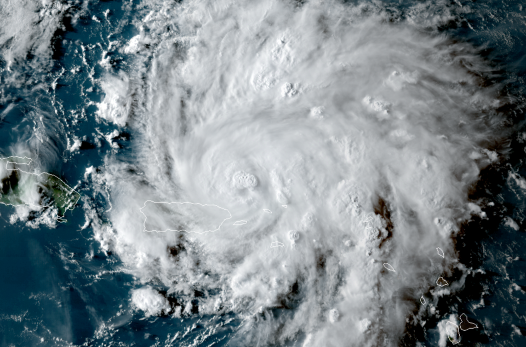
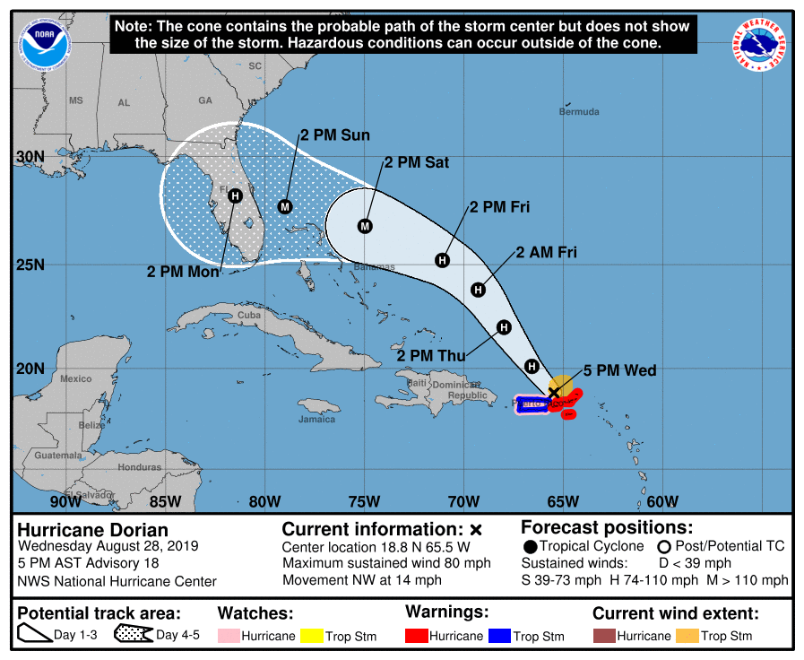
Hurricane Dorian has continued to gradually strengthen this afternoon. The storm traversed the US Virgin Islands today, just 24 hours after making a sudden jog to the north near the Lesser Antilles. Maximum sustained winds have increased to 80 miles per hour per the latest advisory from the National Hurricane Center, and further strengthening is expected in the coming days. By this weekend, Dorian is expected to be a powerful hurricane approaching Florida.
Ensemble guidance diverges in regards to the systems exact track and landfall position. Much of the Southeast United States coast remains at risk.
Technical Analysis: Gradual strengthening may persist
While convection seems to be on a downtrend at this time with Dorian, the overall appearance of the storm is greatly improved from this morning. The outflow pattern has expanded quite a bit to the north and south of the system, allowing Dorian to become better organized. Radar data out of San Juan, Puerto Rico also shows a marked improvement in organization, with a 15-20 mile eye now clearly visible. Bands of very heavy rainfall and strong, gusty winds will continue to lash the US Virgin Islands throughout the night before gradually diminishing tomorrow morning. Thankfully, relatively minor impacts are expected for Puerto Rico over the next 12-18 hours as Dorian continues tracking north of the island, despite gusty winds and heavy rain still occurring.
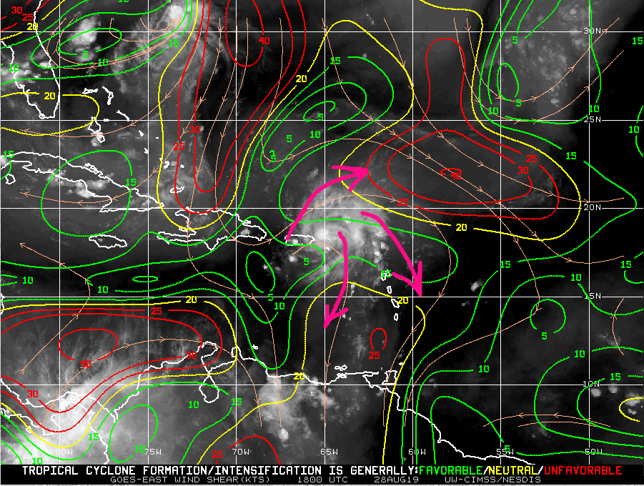
Conditions are expected to remain favorable for at least gradual strengthening of Dorian through this weekend. In fact, model guidance has been trending more favorable with the upper-level air pattern once the storm approaches the Bahamas late this week. Favorable shear in combination with 28-30 C sea-surface temperatures, a very moist mid-level environment, and an established inner-core could perhaps lead to periods of rapid intensification over the next 48-72 hours.
At this time, there are no major limiting factors regarding intensity (outside of an occasional eyewall replacement cycle) for Dorian – and it is likely to become a strong or intense storm over the next few days in the Western Atlantic. The National Hurricane Center is currently (as of 5 pm Wednesday) forecasting Dorian to become a major hurricane by Saturday, with maximum sustained winds of 115 miles per hour.
Chances increasing of Dorian impacting Florida this weekend as a dangerous hurricane
Afternoon model guidance continued to highlight the threat of Dorian making a hard westward turn towards Florida late this week. A ridge of high pressure to the north of the storm is likely to expand, driving the system westward instead of allowing it to escape northward or out to sea. While the models diverge on the exact timing and strength of this feature, confidence has increased greatly that the storm will be forced westward toward the United States.
Additionally, the aforementioned upper-level environment may allow Dorian to “pump the ridge” to it’s north a bit. This phenomenon occurs when strong hurricanes with equally strong poleward outflow channels are positioned just to the south of a growing ridge. The air expended from the core of the hurricane can help act to strengthen the ridge to it’s north, steering the storm more to the west or west-southwest. This was seen with some of the more intense/further north ECMWF ensemble members this afternoon.
Despite consensus on a westward track toward Florida, there is still a great degree of uncertainty as to exactly where the storm will track. Stronger or more intense model guidance suggests a further south track (closer to Miami or South Florida) while faster and slightly weaker model guidance has generally tended to track further north and east (closer to the latitude of Daytona Beach).

The National Hurricane Center’s latest advisory did acknowledge the potential for a more southerly track, and their new track bent southward from the prior advisories. Ultimately, confidence is highest in the Southern or Central Atlantic shoreline of Florida being impacted by Dorian this weekend.
Time to prepare is now in the Southeast US
While confidence is increasing regarding the fact that Dorian will impact the Southeast United States this weekend, particularly Florida, there is no reason to panic. Instead, residents in the Southeast US should begin hurricane preparation and review emergency plans.
In the modern era of meteorology, information is more available than ever. In the coming days, you will likely see thousands of individual model solutions and ensemble plots. Know your information source and read the forecasts carefully. Model guidance is likely to fluctuate and waver with the exact track of the system over the next 48-72 hours as it begins to make a turn toward the United States, and confidence will gradually increase in a direct impact zone. For now, the best course of action is to know the general areas at risk and begin planning accordingly.
So, to reiterate, if you live in Florida – or along the Southeast US coast – now is the time to begin activating your hurricane preparedness plan. If you live in the area and do not have one, visit one of the many resources available to help develop a hurricane plan quickly.
Stay tuned over the next few days as we continue to provide updates on the storms current status and forecast.
Leave a Reply
Want to join the discussion?Feel free to contribute!