Beautiful weather to continue into early next week

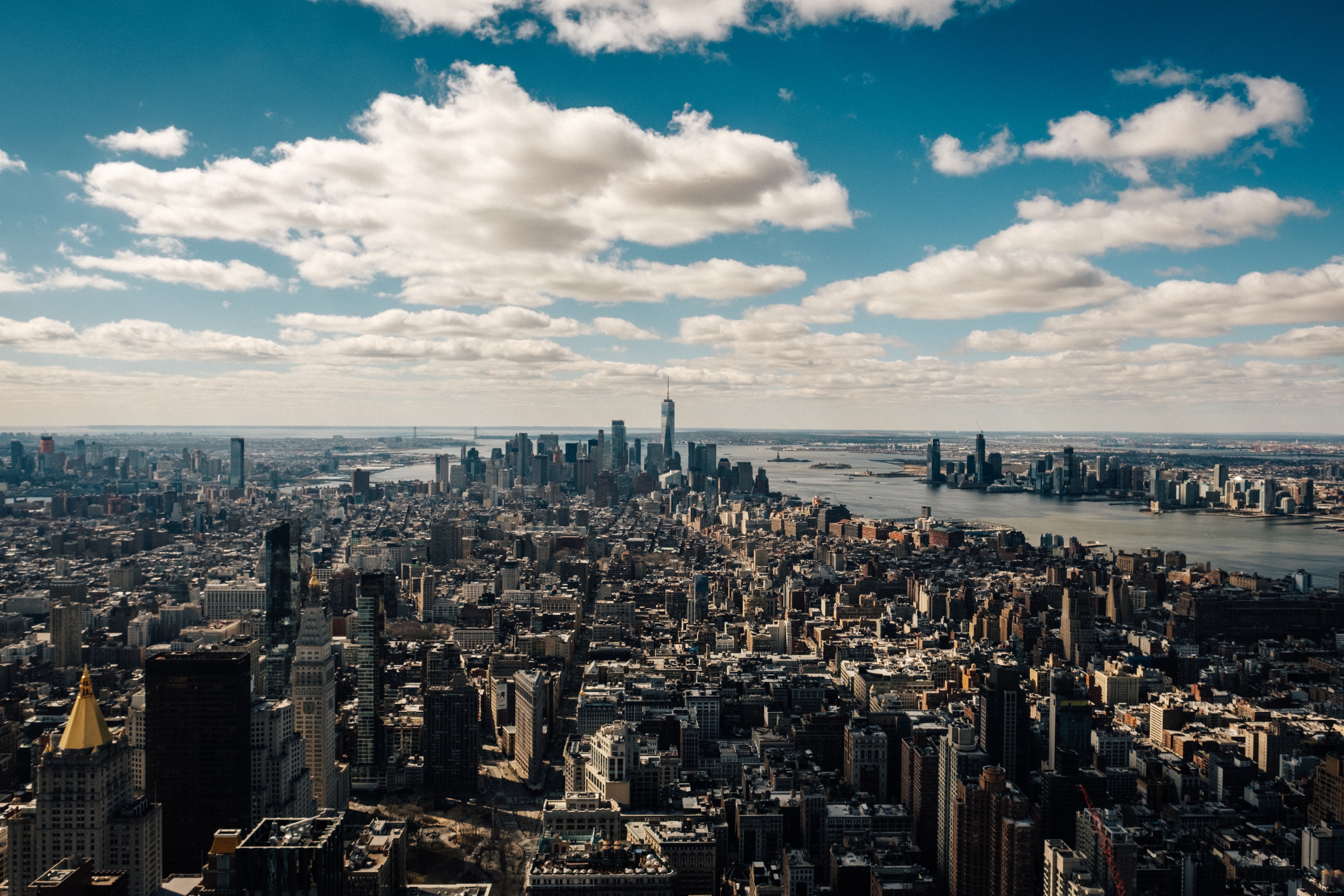
High pressure building in from New England will provide comfortable weather conditions for the next several days. Most notably, lower dew points will settle in and keep the humidity low. Temperatures will average slightly below normal this weekend before creeping back up toward normal by Monday.

The high pressure system will do an admirable job of deflecting storm systems away from the region. A tropical disturbance emerging from the Caribbean will be shunted out to sea, while a few fronts will also be pushed northward into the Great Lakes. Most model guidance has zero precipitation in the NYC Metro area through Tuesday evening.

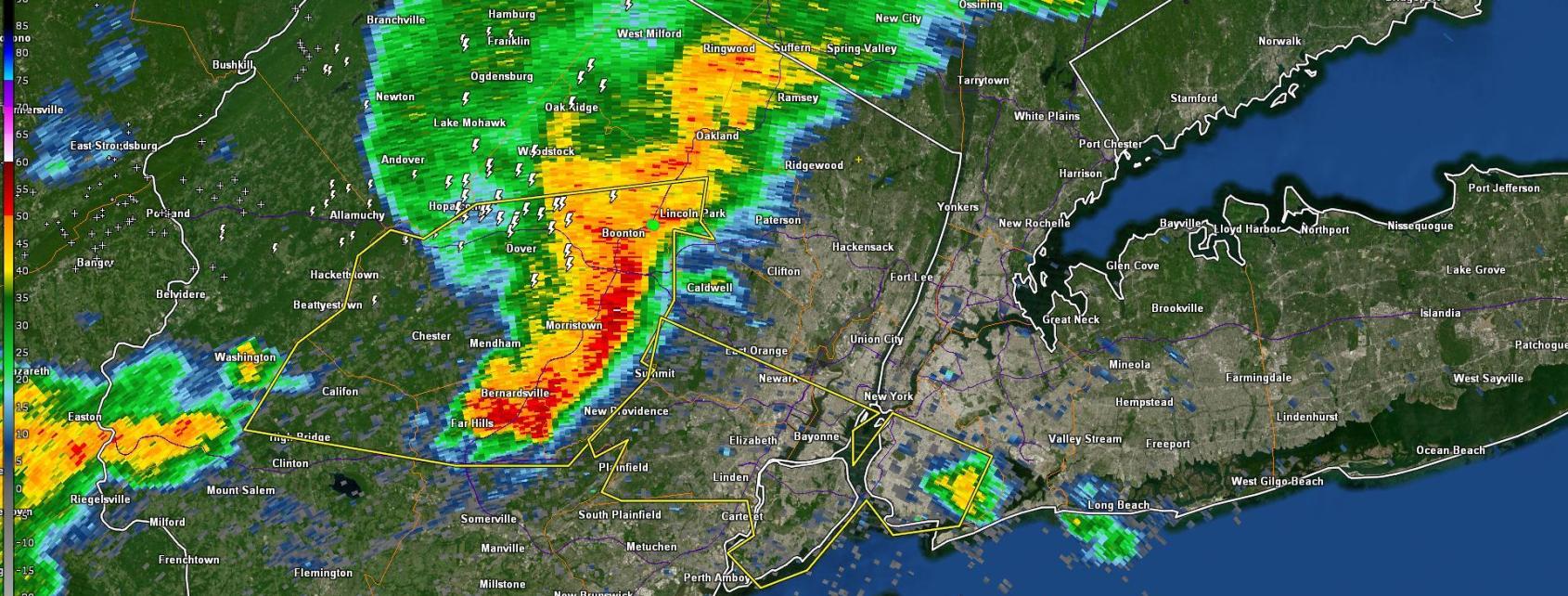
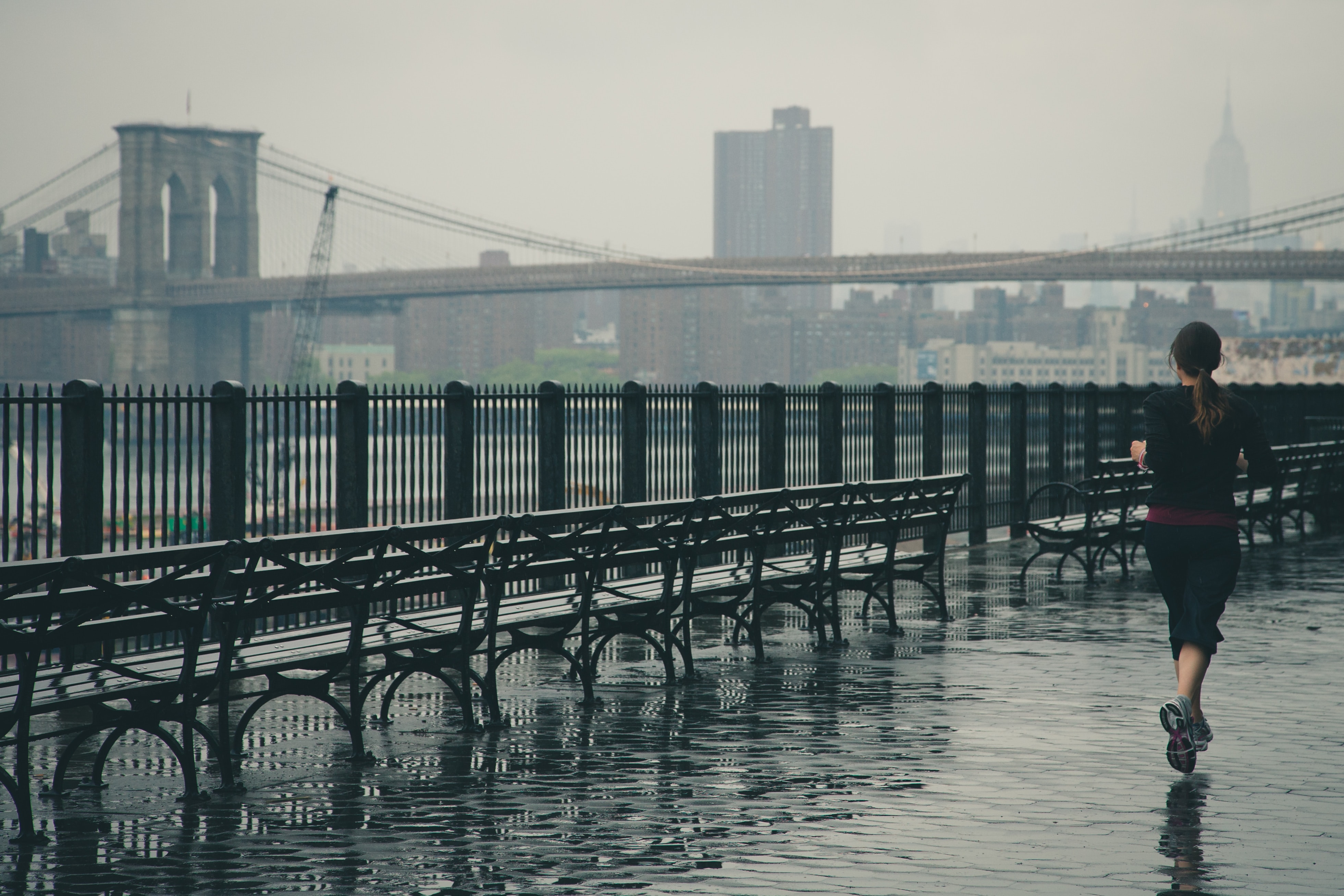
The stretch of calm weather couldn’t come at a better time. New York City has seen several days of strong to severe thunderstorms, high humidity and warm temperatures. In fact, dating back to July, the stretch of abnormal humidity and storminess has lasted almost four weeks.

The next chance for active weather, with precipitation and storm chances, will come during the middle of next week. For now, let’s soak this all in. Here are your highlights:

Now get outside, open those windows and enjoy your weekend!

Severe storm leaves path of damage from PA through Long Island

A complex of severe thunderstorms tracked from Northeast Pennsylvania into New York City on Thursday evening, producing widespread wind damage. The same complex of storms survived all the way to Montauk, almost 200 miles in total length, while still producing widespread damaging winds.

The storms formed in Northeast Pennsylvania during the middle afternoon hours on Wednesday, and quickly began shifting east/southeast toward New Jersey. The atmosphere ahead of the storms was moderately unstable. More notable was the presence of sufficient wind shear – this wind shear helps to keep strong thunderstorms organized and can also transport strong winds down to the surface.

By the early to mid evening hours, the very same storm complex was now pushing through New Jersey. Wind damage reports became more frequent, and as the storm moved through the NYC Metro Area it produced 58mph wind gusts in Tribeca and the Financial District.

The same complex of storms then tracked eastward through Queens and Brooklyn, while maintaining strength. While instability was lower in these areas, ample wind shear and a strengthening low level jet (winds in the lower levels of the atmosphere) helped it maintain intensity.


Over Long Island, the combination of the mentioned instability and strengthening low level jet stream helped the storm to maintain intensity, and also aided in downward transport of winds. This resulted in widespread wind damage reports across Nassau and Suffolk counties throughout the evening.

The storm caused a wall collapse and widespread tree damage in the area from East Farmingdale through Ronkonkoma including Islip and Brentwood. As of this morning, over 20,000 residents remained without power – likely from trees falling on power lines.

While not unheard of, a complex of storms moving from Northeast PA through the NYC Metro and all the way to Montauk is rare. The swath of wind damage reports with this single storm is quite impressive – arguably the most impressive of the summer so far.

Technical breakdown of atmospheric conditions

This storm existed in an environment that was, at best, moderately favorable for severe weather. Instability was present but not extreme (around 1000j/kg of surface based cape). Wind shear was impressive (40 knots of mid level shear for storm organization). Low level wind fields were not overly favorable during the morning but became more favorable by evening. In the end, the storm took full advantage of its environment, riding along a gradient of favorable conditions well into the early evening.

Much of our region was placed within the right entrance region of an impressive jet stream on Thursday, which helped to enhance vertical motion during the evening. But more notable was likely the gradient of instability and the development of a stronger low level jet. This helped to enhance low level winds significantly and likely contributed to the uptick in wind damage reports on Long Island.

The low level jet is known to kick up after sunset (nocturnal low level jet), and in the Midwest and Plains states can help fuel evening outbreaks of tornadoes. In our area, the increasing low level jet helped foster an enhanced threat for wind damage – essentially giving the storm some extra “juice” to continue its trek eastward all the way to Montauk.

Showers linger today before much improved weather arrives

A front will meander near the area today, leading to showery and rainy conditions through the afternoon. As the day goes on, the front will shift southward and by this evening the weather will begin to improve markedly. Dew points will decrease significantly, with much more comfortable air settling in.

Most guidance is in good agreement, though, that showers will be a mainstay in today’s forecast. The front simply isn’t in a hurry to move past our area. It’ll shift south of NYC after 5pm, with the last of the showers out of the metro by 7. As usual, it will take a bit longer to move through parts of Southern New Jersey.

By Saturday, dew points will have dropped into the 50’s throughout the area. This is a huge change compared to what we have been experiencing over the past several days. In fact, by Saturday evening, some areas may see dew points in the 40’s – we haven’t seen those since Spring! The pleasant and refreshing weather is expected to continue through the weekend. Here are your highlights:

  • Showers are likely to persist today near a front that is not in any hurry to move past our area.
  • These will gradually begin clearing the area from north to south later today.
  • Most likely time for improving weather in NYC is 5-7 pm, with much improved weather likely tonight.
  • A major drop in dew points is expected by Saturday, with high temperatures in the 70’s and dew points only in the 50’s.
  • The improved weather will persist through the weekend and into early next week, but a few disturbances may return to the forecast with the chance for showers by early next week once again.

End is finally nigh for humid hellscape in NYC

Millions of NYC Metro Area residents will finally not instantly begin sweating when they walk outside on Saturday morning.

A cold front shifting southward through New England will bring much cooler, less humid, very Canadian air with it. Dew points are forecast to drop from the 70’s today (that is oppressive) into the 40’s by Saturday (that is not oppressive). Northerly winds will also keep a refreshing breeze blowing through the weekend.

We’ll have to get through some more humidity and a few more storms first. A Heat Advisory remains in effect through tonight, with temperatures near 90° F and dew points in the 70’s leading to uncomfortable and oppressive conditions. Another round of storms is also expected this evening as a disturbance swings through.

Here are the highlights over the next few days:

  • Humid and hot again today. A Heat Advisory is still in effect until 8:00pm
  • Storms are possible again, most likely after 7pm and into parts of the overnight hours
  • A few storms could be strong or severe, and although widespread severe weather isn’t expected, any storm could produce strong winds and lightning
  • A dramatic change in the weather is likely from Friday into Saturday as dew points fall almost 30° F
  • Low humidity and sunshine is expected to continue through the weekend