-2")
Live Blog: Dorian nearing Carolinas with rain, wind, surge and tornadoes
Hurricane Dorian strengthened again last night, with maximum sustained winds now at 115 miles per hour. The storm is now a Category 3 Major Hurricane again. Widespread hazardous weather is expected in the Carolinas today with strong wind gusts, torrential rain and dangerous storm surge likely. Tornadoes are also expected as rain bands crash ashore.
Update 8:30am: The tornado potential discussed last night has come to fruition, with multiple reports of tornadoes as supercells crash ashore in the rain bands of Hurricane Dorian. Forecast model guidance suggests a continued threat for tornadoes today. In fact, the tornado potential may become maximized over parts of North Carolina this afternoon.
Tornadoes in tropical cyclones typically occur in the northeast quadrant of the system, and in areas of enhanced low level helicity and wind shear. Forecast model guidance today suggests very impressive levels of wind shear in the lowest 3km and 1km of the atmosphere in the northeast quadrant of the system.
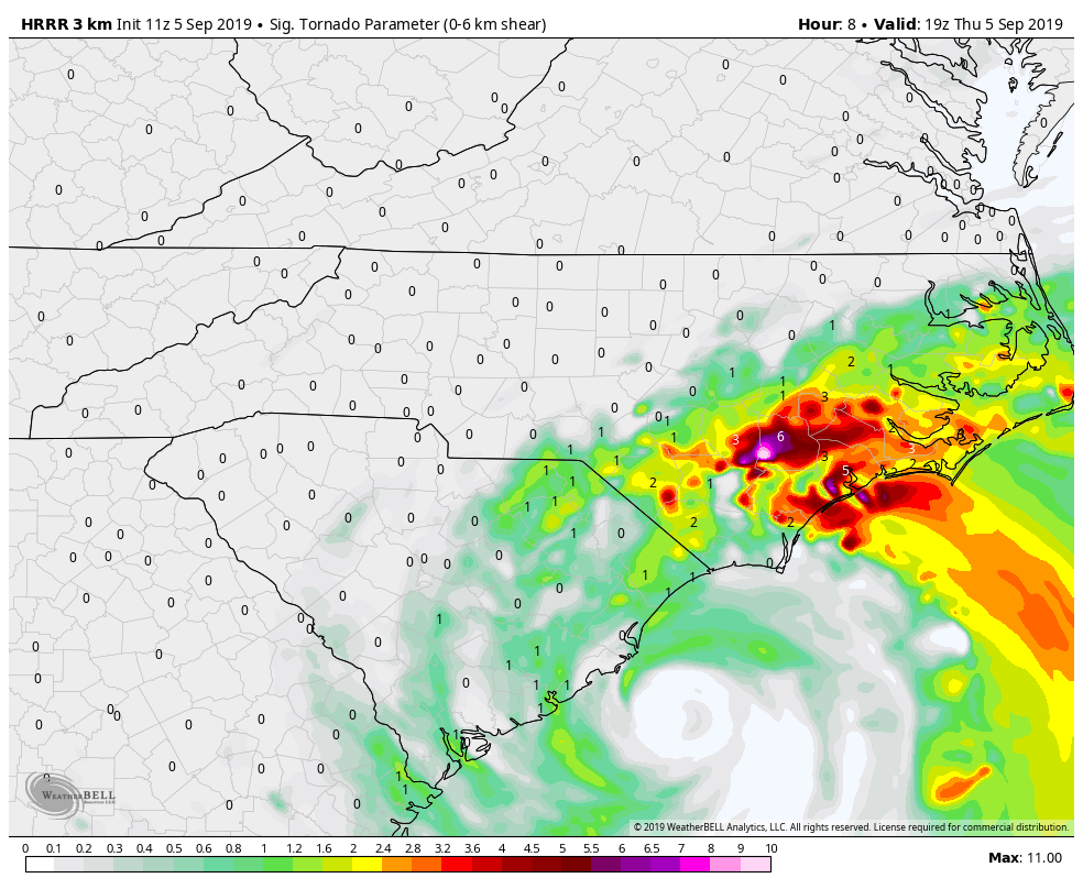
HRRR Significant Tornado Parameter this afternoon 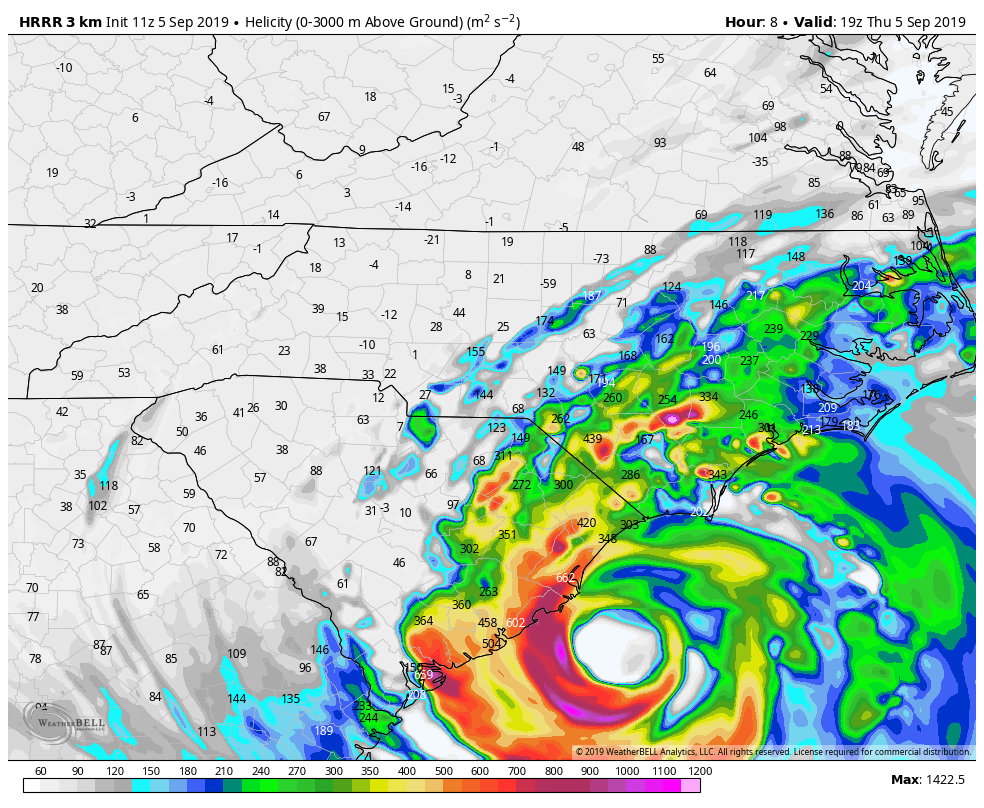
HRRR showing impressive 0-3km helicity today
In addition, unusually high atmospheric instability is forecast, with surface based CAPE (Convective Available Potential Energy) over 1500 j/kg in parts of North Carolina. This is on the higher end of what is typically observed in these synoptic setups. As a result, the Storm Prediction Center has issued a 15% tornado probability and upgraded to an Enhanced Risk in parts of North Carolina later today.
The tornado potential may be maximized from 11am through 5pm, when rain bands of Dorian crash ashore and interact with the juxtaposition of instability and extreme wind shear. Forecast soundings suggest the potential for multiple supercells and tornadoes. Residents should prepare for the potential tornadoes and heed all warnings issued by the National Weather Service. These tornadoes will move quickly – seek shelter immediately if you are in warned area.
Update 11:00pm: Hurricane Dorian has strengthened once again, now a Category 3 Major Hurricane with maximum sustained winds of 115 miles per hour. The storm is continuing northwestward, sitting just more than 100 miles southeast of Charleston, South Carolina.
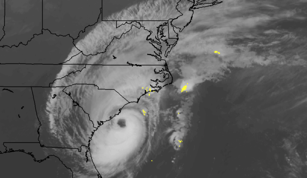
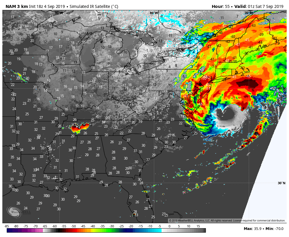
The National Hurricane Center reiterated in their latest discussion that life threatening storm surge is expected as the storm moves towards the coast. Recently, satellite appearance has become more impressive. Deep thunderstorm activity is wrapping around the storms center.

In the visible satellite imagery above, notice the darker colors indicating colder cloud tops. The stronger convection began developing and organizing more steadily this afternoon and evening when the storm passed over the warmer waters of the Gulf Stream with a reinvigorated eyewall.
Update 8:40pm: The latest recon pass through Hurricane Dorian found estimated surface winds of 114mph in the southwestern eyewall. These are some of the strongest winds observed in almost 36 hours since the storm underwent a structural change.
Dorian has expanded greatly in size over the past 24-48 hours after a prolonged period of interaction with Grand Bahama island. The storm underwent an ERC, or eyewall replacement cycle, yesterda – with a complete collapse of its original inner eyewall. The second, larger eyewall has taken over and the storm has begun strengthening again.

An eyewall replacement cycle is a naturally occurring process in strong tropical cyclones. Bands of heavy rainfall and strong winds can form around the original small eyewall – gradually robbing the inner eyewall of the moisture and momentum it had once been sustaining. The process balances itself out as the inner eyewall collapses and the larger eyewall around it takes over.
Dorian has also moved away from water which it had upwelled and overturned when it stalled to a crawl a few days ago. It is now in the presence of the warmer waters near the Gulf Stream, and has since become more organized. Microwave imagery earlier today showed a reinvigorated core – and despite the systems larger size, some additional strengthening is possible before it reaches the coastline.
Impacts along the Southeast US Coast will be significant
Dorian is currently 130 miles Southeast of Charleston, SC and moving northwestward. Life-threatening storm surge is expected along a large majority of the Southeast US coastline as Dorian approaches from this evening into Thursday. Strong winds are also expected as the storm approaches, especially with a larger storm system and organized core structure.
Both of these threats will be especially apparent along the South Carolina coast. Latest forecast model guidance shows a very concerning situation there throughout the majority of the day on Thursday.
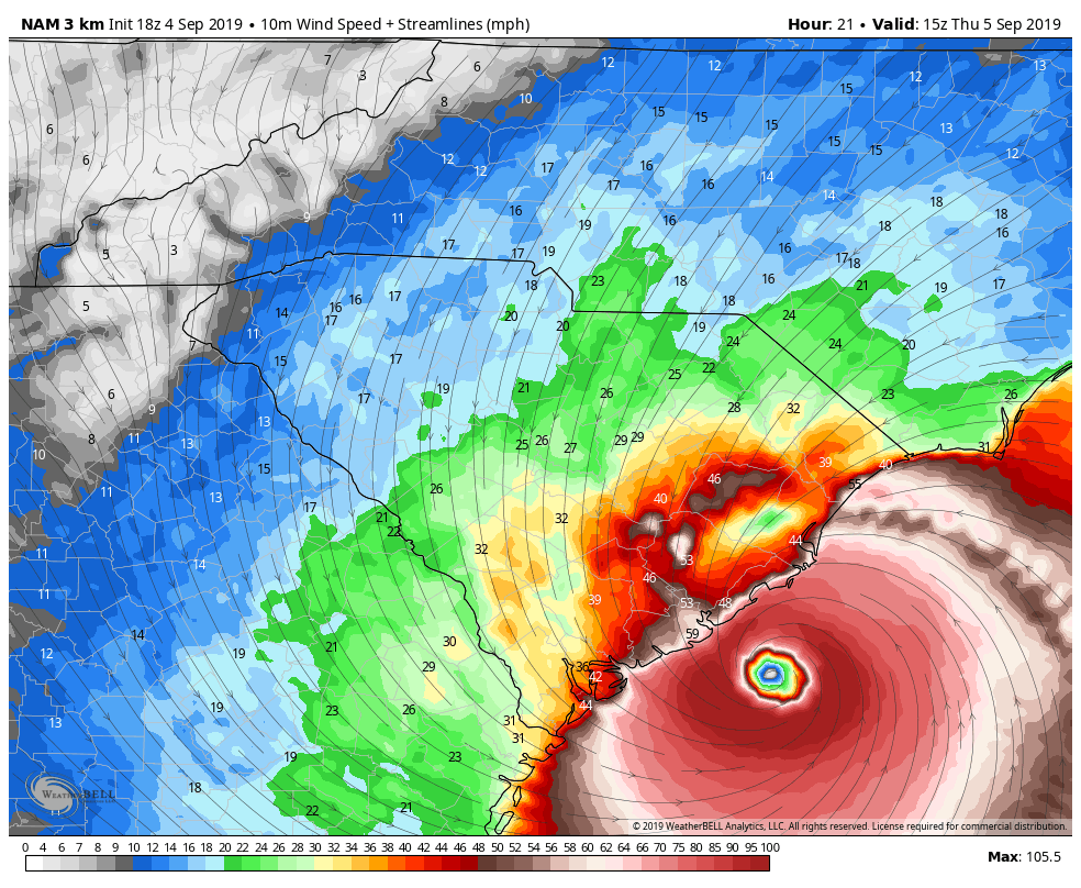
NAM model suggesting very strong winds along the SC Coast on Thursday. 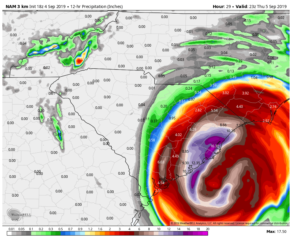
Over 10″ of rainfall is possible over a large area in just 12 hours on Thursday.
First, east/northeasterly flow will strengthen and hurricane force winds will ramp up along the coastline. Gusts to Category 2 hurricane force are likely along the immediate coasts, and onshore winds will bring a storm surge of 4 to 6 feet. This will lead to widespread coastal flooding and beach erosion.
In addition, torrential rainfall is likely as the deep, tropical moisture from Dorian begins to move onshore. Enhanced lift in the atmosphere will allow for impressive rainfall totals. The latest NAM3km, for example, suggests the potential for over 16″ of rain in just 12 hours in parts of South Carolina.
As if the rain, wind, and storm surge wasn’t enough – Dorian will begin to interact with some increased atmospheric instability as it approaches land. The combination of wind shear and instability will lead to the potential for tornadoes along the South and North Carolina coastlines.
Bottom Line: Widespread impacts are likely along the Georgia, South Carolina and North Carolina coastline. Life threatening storm surge and flooding is likely particularly in South Carolina. Residents should heed all evacuation warnings – and if you are not being evacuated, have a hurricane and flood plan in place.
Links: National Hurricane Center | Storm Surge Forecast | Evacuation Info
Dorian will slide southeast of New England late week
After ravaging the Southeast United States and part of the Southern Mid-Atlantic coast, Dorian is thankfully expected to slide northeastward out to sea. A cold frontal boundary and atmospheric disturbance can be thanked for that, as the steering currents guide the storm to the northeast.
Clouds and some tropical showers may affect portions of Southeast New Jersey, Eastern Long Island, and Southeast New England on Friday as Dorian begins to undergo an extratropical transition. These are very likely to stay to the Southeast of New York City, but the clouds will still affect most of the area.
After Dorian passes to our northeast on Friday, improving weather is anticipated this weekend. We can assure you that we won’t be sad waving goodbye to Dorian as it makes its exit into the higher latitudes.
Trackbacks & Pingbacks
2portions
Leave a Reply
Want to join the discussion?Feel free to contribute!