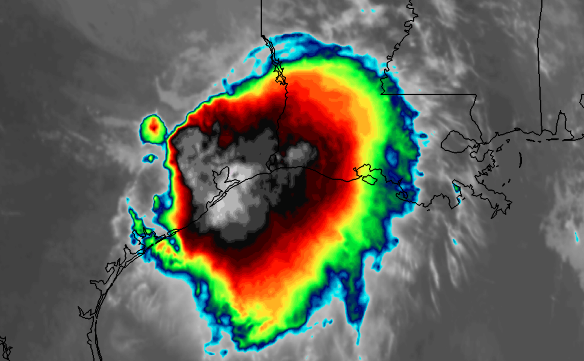
Two years removed from Hurricane Harvey, which brought over 60″ of rainfall to parts of Southeast Texas, areas near Houston are experiencing generational flooding once again. Rainfall totals of over 40″ have been reported over the past three days from the remnants of Tropical Storm Imelda.
High pressure will remain in control for the next few days, with calm and dry weather expected. Temperatures will remain cooler and crisp through the end of the week, before warming up this weekend. High temperatures may eventually reach several degrees above normal.
https://www.nymetroweather.com/wp-content/uploads/2019/09/collin-armstrong-xE9M6xadoJY-unsplash.jpg28485076John Homenukhttps://www.nymetroweather.com/wp-content/uploads/2024/02/Empire-2000-x-300-px-2.pngJohn Homenuk2019-09-19 11:04:072019-09-19 11:04:47Dry, calm weather to continue in NYC as foliage perks up
Tropical Storm Jerry strengthened again today, with maximum sustained winds now at 60 miles per hour. The storm is moving steadily northwestward in the Tropical Atlantic Ocean. It is expected to move north of the Antilles later this week, while strengthening into a hurricane.
Latest IR Satellite imagery of Tropical Storm Jerry located over the Central Atlantic with sustained winds of 60 mph
The eventual track of the cyclone remains uncertain. Most forecast models and ensembles suggest the highest probability scenario is that the system will curve northward and into the open Atlantic. A nontrivial amount of ensemble members, however, suggest the storm could track further south – closer to the Caribbean Islands.
Uncertainty rooted in Jerry’s strength
Often times, a large spread in potential solutions or tracks can be overwhelming. For meteorologists and weather forecasters alike, it is important to try and understand the root of these differences. In other words, what is causing each ensemble member to act differently than the others?
In this situation, there are two clear camps in regards to the track of Jerry over the next 5 days. One group (a larger amount of ensembles) take the storm further north and eventually curve it out to sea. Another group (smaller amount of ensembles) take the storm further south, toward the Caribbean Islands.
12z ECMWF Ensemble members showing the potential tracks for Jerry over the next four days. Note the stronger members (darker colors) are further south.
The members which are further south with Jerry have one thing in common: They are stronger with the storm system over the next 48 hours. The stronger, more organized system responds differently to its surroundings and pushes further southward as a result. The northward members allow the system to drift northward and eventually recurve.
As you may imagine, it will be critical to monitor the storms organization over the next 48-72 hours. We’ll be watching both the organization of the storm and trends among the medium range weather models. Confidence in regards to the storms track should begin to increase steadily thereafter.
Stay tuned for updates over the next few days as the eventual fate of Tropical Storm Jerry becomes more clear.
https://www.nymetroweather.com/wp-content/uploads/2019/09/Screen-Shot-2019-09-18-at-9.02.32-PM.png12742082John Homenukhttps://www.nymetroweather.com/wp-content/uploads/2024/02/Empire-2000-x-300-px-2.pngJohn Homenuk2019-09-18 21:04:322019-09-18 21:04:41Tropical Storm Jerry strengthens, recurve not a guarantee
An expansive high pressure system will build over New England beginning today, leading to a prolonged period warm and dry weather in the Northeast. Temperatures are likely to average a few degrees above normal over the next week, with very little threat of substantial precipitation or significant storms.
Hi friends! Our website uses cookies to provide an optimal browsing experience for you. New "Cookie Consent" laws mandate us to inform you of this. As long as you're cool with it, just hit OK. You'll only see this message once.
We may request cookies to be set on your device. We use cookies to let us know when you visit our websites, how you interact with us, to enrich your user experience, and to customize your relationship with our website.
Click on the different category headings to find out more. You can also change some of your preferences. Note that blocking some types of cookies may impact your experience on our websites and the services we are able to offer.
Essential Website Cookies
These cookies are strictly necessary to provide you with services available through our website and to use some of its features.
Because these cookies are strictly necessary to deliver the website, refusing them will have impact how our site functions. You always can block or delete cookies by changing your browser settings and force blocking all cookies on this website. But this will always prompt you to accept/refuse cookies when revisiting our site.
We fully respect if you want to refuse cookies but to avoid asking you again and again kindly allow us to store a cookie for that. You are free to opt out any time or opt in for other cookies to get a better experience. If you refuse cookies we will remove all set cookies in our domain.
We provide you with a list of stored cookies on your computer in our domain so you can check what we stored. Due to security reasons we are not able to show or modify cookies from other domains. You can check these in your browser security settings.
Other external services
We also use different external services like Google Webfonts, Google Maps, and external Video providers. Since these providers may collect personal data like your IP address we allow you to block them here. Please be aware that this might heavily reduce the functionality and appearance of our site. Changes will take effect once you reload the page.
-2")