-2")
Huge ridge developing in the Gulf of Alaska, what does it mean for us?
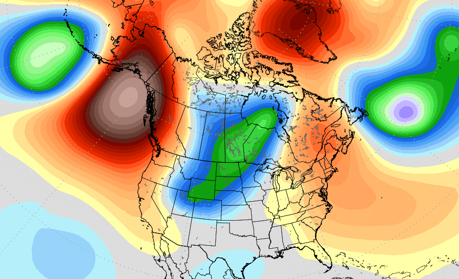
Forecast models are in strong agreement that a large and anomalous ridge will develop in the Gulf of Alaska over the next few days. The resulting wave pattern in the atmosphere will lead to colder than normal air in the Rockies, Midwest and Plains states.
Typhoon Bualoi, in the Western Pacific Ocean, is forecast to recurve into the Northern Pacific over the next several days. Its interaction and amplification within the mid level jet stream will cause a larger-scale amplification of atmospheric waves in the Northern Pacific Ocean. In simple terms, the typhoon recurve will amplify the atmospheric pattern in that area.
This will help to force the development of a huge ridge in the Gulf of Alaska. Forecast model and ensemble guidance suggests that this ridge could be one of the strongest on record in that region during this time of year.

Some numbers:
- The ECMWF suggests the ridge will reach the 99.5th percentile of climatology at 500mb
- The GFS suggests a nearly 100% chance that the ridge will reach at least the 97.5th percentile for climatology at 500mb
In other words, this is an extremely anomalous event. Both major forecast model and ensemble suites are suggesting that this ridge will reach the upper periphery of climatology for this time of year.
What does it mean for the United States?
The affects of such an amplified and anomalous weather pattern can be far reaching. In this scenario, we can look at the simple result of the wave evolution throughout the atmosphere for some answers.
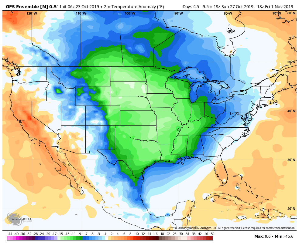
The large ridge that builds over Alaska forces a significant trough to sink southward from Canada into the United States. The airmass associated with this trough has very little Pacific air influence. Accordingly, notable cold air sinks southward into the Intermountain West and Plains states, eventually reaching eastward towards the Midwest, Ohio Valley and East Coast (though the airmass will likely modify and be less intense once it reaches us).
In the Northeast US, the main uncertainty lies in regards to how intense the cold air actually is once it gets here. When cold air drops southward into the Rockies or Plains, it often modifies to its surroundings before it reaches us. This means that the brunt of the truly cold air remains to our west. If the cold shot is more persistent, however, with multiple “surges” of cold from Canada, we could see impressive cold in the Northeast as well.
Regardless, the national temperature profile looks likely to trend much colder over the next few days. Most forecast models and ensembles suggest the potential for several days of anomalous cold in the Intermountain West, Plains and Midwest which will undoubtedly have a major impact on several key industries.
Let’s back up for a second. Typhoon Bualoi recurves in the Northern Pacific, amplifying the wave pattern. The timing and intensity of that recurve leads to a large ridge that develops in the Gulf of Alaska. That ridge helps to amplify a trough southward from Canada into the United States. The airmass from that trough brings much colder than normal temperatures to the Plains, Midwest and parts of the East Coast.
Isn’t meteorology amazing?
We’ll have more on the direct impacts for the United States, including any potential storm systems associated with this colder than normal airmass, over the next few days. Stay tuned and enjoy the lovely Autumn weather!
Leave a Reply
Want to join the discussion?Feel free to contribute!