An active and cooler weather pattern is expected to continue, with another round of showers tonight. A frontal boundary approaching the region from the west will lead to increasingly unsettled conditions as the day goes on. The heaviest rain will likely come between 7 and 9 pm, with some localized flooding possible.
Conditions are expected to improve as we go through the later part of the evening. Westerly winds will usher in cooler and drier air, with pleasant weather expected on both Wednesday and Thursday. The next chance of rain won’t arrive until later Friday and perhaps Saturday.
A strong coastal storm will develop later today and tonight, and heavy rainfall is expected throughout the NYC Metro Area. The heavy rainfall will cause travel delays and will result in a slower than usual PM Commute. It is also likely to heavily impact ALCS Game 4, which we are projecting to be rained out.
The storm system is developing as a result of a phase in the mid levels of the atmosphere. Two disturbances will interact over the Mid Atlantic and Northeast states later today, aiding in the development of a strong surface low pressure area. Impressive jet stream dynamics in the atmosphere will support the storm strengthening quickly tonight.
The lowdown on timing, intensity and impacts
Heavy rainfall is likely to develop from late this morning into the early afternoon across much of Southeast Pennsylvania and New Jersey. Much like a winter storm, this precipitation will spread gradually northward towards New York City during the afternoon hours.
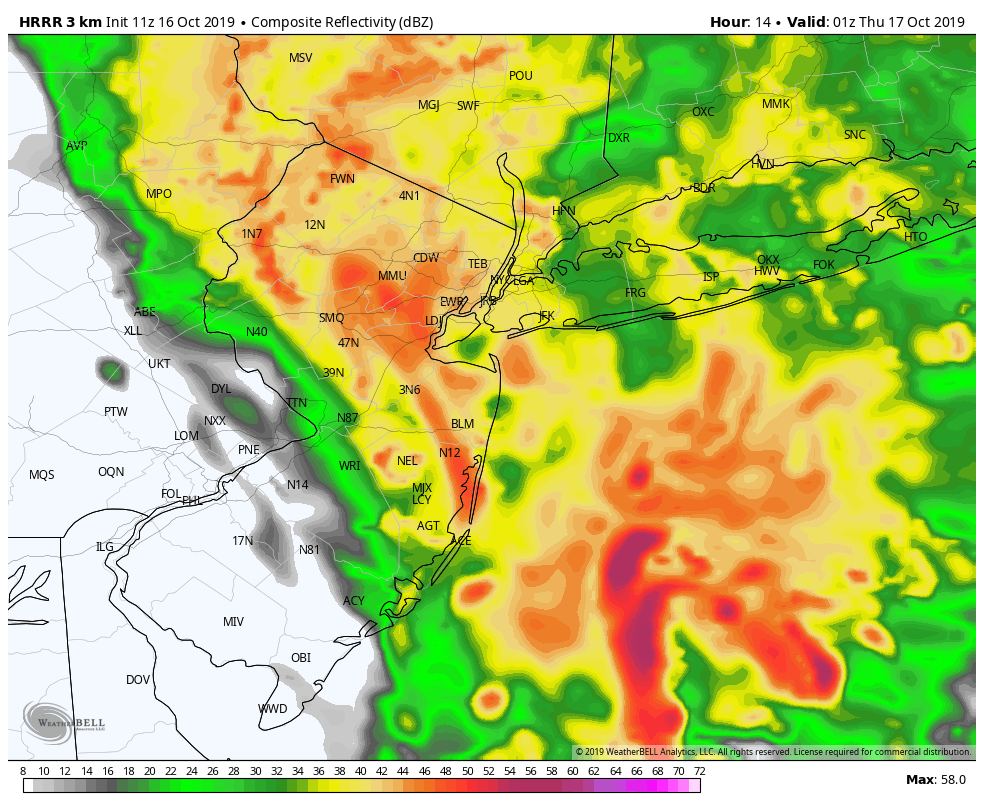
The current expectation is that steady rainfall will have started in the NYC Metro Area by 4:00pm, increasing in intensity by 5:00pm. The rainfall will gradually become heavier in the hour or two that follows. With rainfall intensity picking up, localized flooding is possible throughout the area. This will be especially true during the second half of the evening commute.
Torrential rainfall is likely tonight, especially between 7:00 and 9:00pm
The heaviest rainfall and most impressive dynamics will arrive in the NYC Metro Area between 7:00pm and 9:00pm. During this time, torrential rainfall is likely. Southeast winds will increase and gust over 30mph at times. Localized flooding is again likely, especially in poor drainage areas and near the coast.
As we move closer to 10:00pm, rainfall rates will begin to dissipate from southwest to northeast as a dry slot approaches the area. Rainfall is expected to slow considerably as we approach midnight. Gusty winds will continue, and turn northwesterly as the storm strengthens to our north.
If there is one bit of good news, it’s that this system will be in and out of the area in just several hours. While the storm system is strong, it’s undergoing the most strengthening to our north over New England. As a result, we won’t have to deal with multiple days of rainfall.
Yankees and Astros ALCS Game 4 Rainout is likely
There have been minimal changes to our SportsCast forecast for ALCS Game 4 in the Bronx tonight. We are still forecasting a 95% chance of a delay or cancellation, with torrential rainfall and gusty winds likely before and during the games scheduled start time.
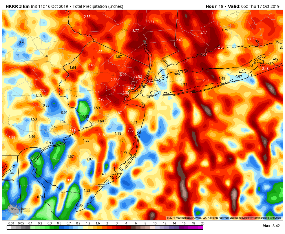
Rainfall totals with the coastal storm could approach 3″ in some areas near NYC
The 5% we left out of the forecast for a delay accounts for the possibility that MLB will choose to “wait out” the storm and play the game later than its scheduled time tonight. We are of the opinion that this would be an exceptionally poor decision – with soggy conditions on the field and localized flooding/travel issues for fans after 3″ of rainfall – but we did account for it in our projection.
Otherwise, we are operating under the full expectation that tonight’s game will not be played. It is worth noting, too, that strong northwesterly winds are expected on Thursday. This means the wind will be blowing out to right field at Yankee Stadium – which as we all know is something to note.
Stay tuned for further updates throughout the day on the developing storm system
https://www.nymetroweather.com/wp-content/uploads/2019/10/gabriele-diwald-Kwi60PbAM9I-unsplash.jpg24923723John Homenukhttps://www.nymetroweather.com/wp-content/uploads/2024/02/Empire-2000-x-300-px-2.pngJohn Homenuk2019-10-16 09:10:452019-10-16 09:11:48Heavy rain expected today, ALCS Game 4 likely to be rained out
The second coastal storm in as many weeks will develop on Wednesday off the shores of the Mid-Atlantic, swinging northward towards New England while strengthening. By Thursday morning, the system will be located near Eastern New England, and may be strong enough to set monthly low pressure records in some areas.
Last weeks coastal storm, while impressive and subtropical in nature, was situated further offshore and moving much slower. This storm is occurring as a result of a dynamic “phase” in the mid levels of the atmosphere. This occurs when two disturbances interact with one another, often forcing the development of a strong low pressure system at the surface.
A large coastal storm has formed this week, and will continue to meander offshore for the next few days. Moderate to heavy rainfall fell across parts of the Mid Atlantic and New England Coast today as bands from the system moved westward. North/northeast winds have kept temperatures very cool.
Hi friends! Our website uses cookies to provide an optimal browsing experience for you. New "Cookie Consent" laws mandate us to inform you of this. As long as you're cool with it, just hit OK. You'll only see this message once.
We may request cookies to be set on your device. We use cookies to let us know when you visit our websites, how you interact with us, to enrich your user experience, and to customize your relationship with our website.
Click on the different category headings to find out more. You can also change some of your preferences. Note that blocking some types of cookies may impact your experience on our websites and the services we are able to offer.
Essential Website Cookies
These cookies are strictly necessary to provide you with services available through our website and to use some of its features.
Because these cookies are strictly necessary to deliver the website, refusing them will have impact how our site functions. You always can block or delete cookies by changing your browser settings and force blocking all cookies on this website. But this will always prompt you to accept/refuse cookies when revisiting our site.
We fully respect if you want to refuse cookies but to avoid asking you again and again kindly allow us to store a cookie for that. You are free to opt out any time or opt in for other cookies to get a better experience. If you refuse cookies we will remove all set cookies in our domain.
We provide you with a list of stored cookies on your computer in our domain so you can check what we stored. Due to security reasons we are not able to show or modify cookies from other domains. You can check these in your browser security settings.
Other external services
We also use different external services like Google Webfonts, Google Maps, and external Video providers. Since these providers may collect personal data like your IP address we allow you to block them here. Please be aware that this might heavily reduce the functionality and appearance of our site. Changes will take effect once you reload the page.
-2")