-2")

Warmth, storms on Friday will be followed by colder weather
Showery and drizzly weather over the past 24 hours has been the sign of an incoming storm system. A warm front is lifting slowly northward through the Mid-Atlantic states this evening, and will make its way through NYC during the morning hours on Friday. Warm air (thanks, southwest winds!) will then come surging in. Here’s how the forecast will shake down over the next few days:
Friday and Saturday
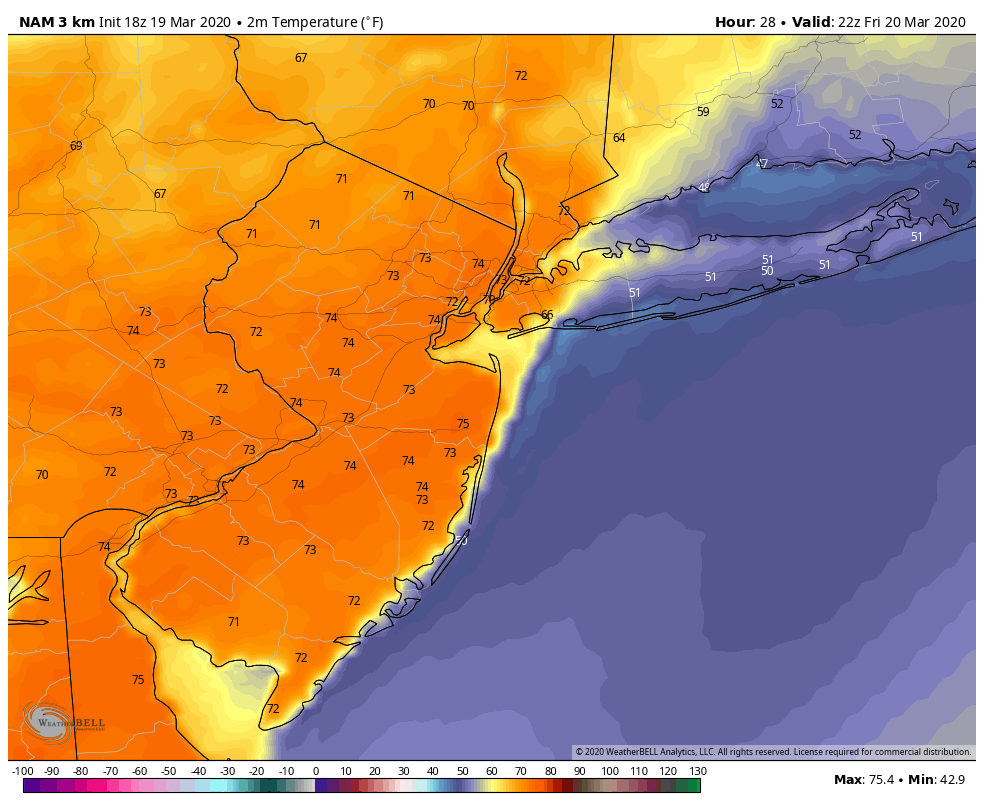
After cloudy and showery weather in the morning, a warm front moves through the area and clouds clear. Temperatures will skyrocket into the 70’s in most of the area. The exception will be Long Island and the area shores, where temperatures will remain cooler thanks to cloud cover and the ocean breeze.
Elsewhere, the warmest afternoon of the year to date is expected. High temperatures may very well approach the upper 70’s in parts of Southern and Central New Jersey. Forecast models tend to under-do temperatures this time of year, so we expect much of the same this time around.
During the late afternoon and early evening, a frontal boundary begins approaching the area from the northwest. The atmosphere will be at least slightly unstable thanks to the warmth and humidity. Enough wind shear will also be present to organize thunderstorms – especially across interior parts of PA, NJ and NY. Storms should gradually weaken and move off the coast during the early to mid evening hours. The Storm Prediction Center has placed our area in a Marginal Risk (level 2 out of 5) for severe weather. We don’t expect much severe weather, but a few stronger storms could produce gusty winds and lightning.
By Saturday morning, much colder air will come rushing in from the northwest. Highs may only reach into the upper 40’s – a full 25 degrees colder than Friday.
Sunday and Monday
Cold air from Canada surges back into the area (groan) behind the storm system. Blustery conditions from Saturday may continue into parts of Sunday. Temperatures will average colder than normal during this period.
A disturbance moves through the Ohio Valley and eventually off the East Coast on Monday. There is just enough cold air hanging around to raise some eyebrows with this setup – if precipitation is timed properly, some snow is possible in the interior and parts of New England.

Both the GFS and Euro models support this overall solution, which brings a low pressure system off the Mid-Atlantic coast and allows some wintry precipitation to fall in Northern PA, Northern NJ and Southern New England. In NYC, the airmass and weather pattern is simply not cold enough or supportive of snow. But in the interior, the potential for some flakes and light accumulations does exist.
We’ll have more on this storm as we move through the weekend and the details become more clear.
Until then, stick around – and continue to practice smart and safe social distancing while remaining healthy. We are all in this together.
Trackbacks & Pingbacks
3archduke
Leave a Reply
Want to join the discussion?Feel free to contribute!