-2")
Tropical Storm Warning for NYC: Isaias to bring heavy rain, strong winds
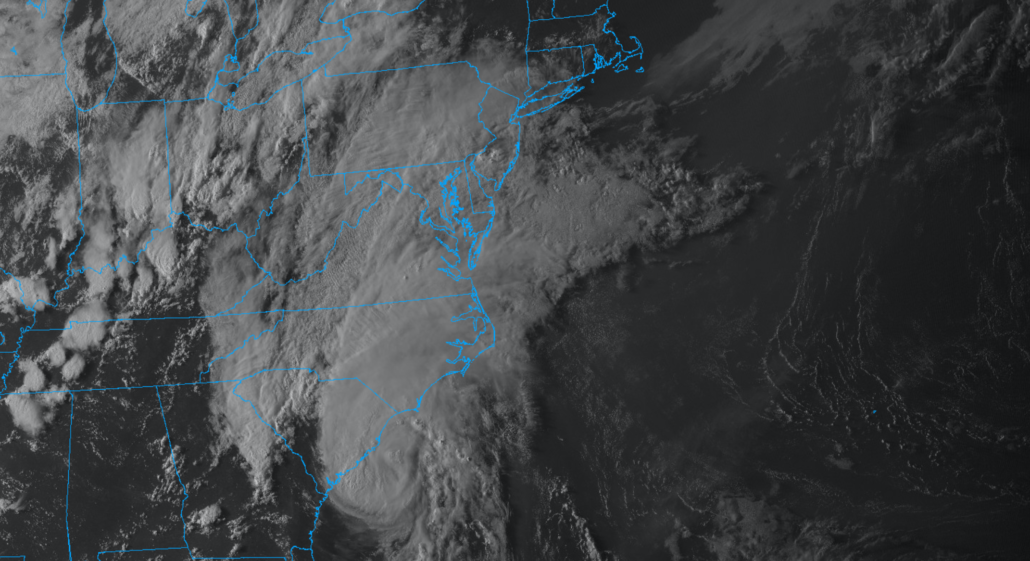
Tropical Storm Isaias is approaching the coast of the Carolinas this evening and is expected to make landfall as a hurricane tonight. Tropical moisture will surge northward through the Mid Atlantic his evening, setting the stage for a period of torrential rainfall and flooding across the NYC Area on Tuesday.
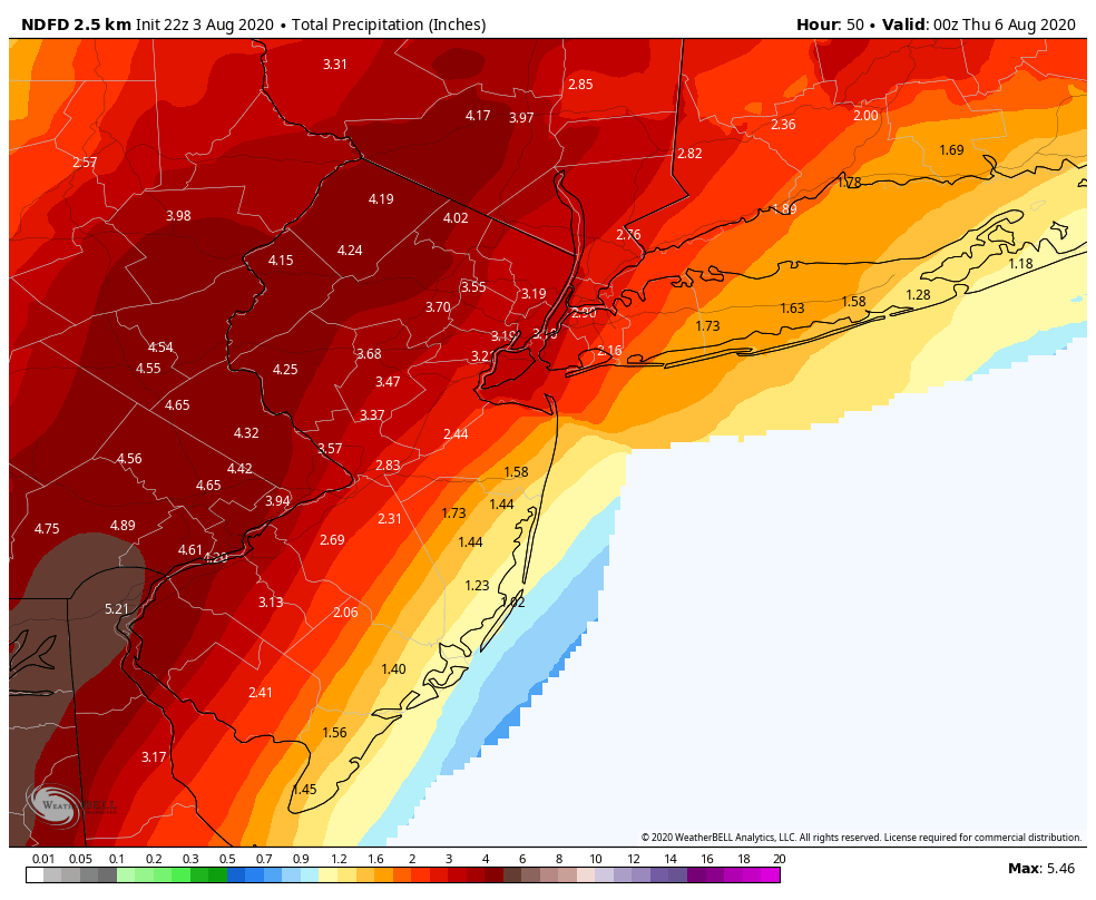
Rainfall amounts of 4 to 6 inches are likely across parts of Pennsylvania and New Jersey as Isaias moves northward on Tuesday. Amounts will be lighter in the NYC Metro and Long Island, but rainfall totals there could still be significant. Flooding is likely across the hardest hit areas, with the potential for rainfall totals approaching 8 inches in some locations.

The potential will also exist for strong wind gusts along the area coasts. Tropical Storm Isaias is forecast to move northward through the Mid Atlantic and towards New Jersey on Tuesday, and as it does so southeasterly winds will dramatically increase near the area coasts. On Tuesday afternoon, the potential for will exist for wind gusts from 40 to 70 miles per hour along the New Jersey, New York and Connecticut coasts. These winds will be strongest closest to the coast and east of the track of Isaias.
Heavy Rainfall likely to cause widespread flooding
Bands of torrential rain are expected to begin moving into the area on Monday evening. Rain will expand well to the north of Isaias’ track, as a result of an impressive jet streak in the upper levels of the atmosphere. Areas of heavy rainfall will expand across the area by Tuesday morning.
The most focused area of heavy rainfall potential will come near and just north of the storms track. This is currently forecast to be across Eastern Pennsylvania and Western New Jersey. Here, the potential exists for 4 to 6 inches of rainfall, with isolated amounts up to 8 inches. The combination of heavy rainfall and gusty winds could lead to power outages and downed trees as well.
The heaviest rain is likely to fall from 8am Monday through 2pm Tuesday, though torrential rains may also continue after that time as the system lifts northward. Heavy rains are also possible further east, in areas like New York City, Eastern New Jersey and Long Island, but will be more sporadic in nature.
Strong winds likely, especially near the area coasts
As Isaias approaches the area on Tuesday, a significant increase in wind gusts is expected. Most areas should see wind gusts to tropical storm force, with sustained winds from 15 to 20 miles per hour.
The worst of the winds will be further east, across Eastern New Jersey and Long Island. Southeast winds will ramp up during the late morning and afternoon hours with Isaias moving from the Mid Atlantic closer to the region. Wind gusts from 50 to 70 miles per hour are possible along the area coasts during this time – particularly from 12pm to 4pm.
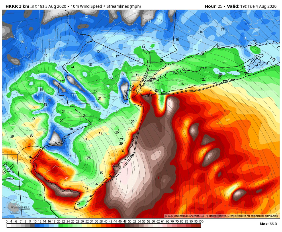
The strong wind gusts and onshore component to the wind flow could lead to coastal flooding and storm surge. This will be especially true on the coasts of New Jersey and Southern Long Island.
Tornadoes and waterspouts also possible
Forecast models suggest that atmospheric instability will increase to the northeast of Isaias as it approaches the area on Tuesday. The combination of ample instability and extreme wind shear will lead to the potential for waterspouts and tornadoes.
These will be most likely across the area coasts, as well as Eastern New Jersey, New York City, Long Island and Connecticut. Storms to the east/northeast of Isaias’ track will be moving very quickly and could begin rotating quickly as well, producing fast moving but damaging tornadoes.
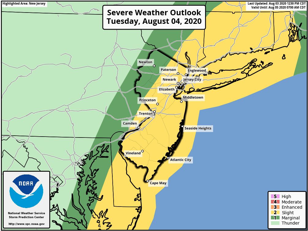
The Storm Prediction Center has placed the aforementioned regions in a Slight Risk for severe thunderstorms, specifically for the threat of tornadoes and damaging wind gusts. The most likely time for tornado activity will be between 12pm and 4pm, beginning along the SE NJ coast and moving northward towards Long Island and then Connecticut.
Preparedness and safety steps
Tropical Storm Isaias is likely to be a moderate to high impact event for the majority of the forecast area, specifically near the coasts. Impacts ranging from heavy rain to strong winds and tornadoes are likely on Tuesday. The potential exists for power outages across the entire area.
This does not mean it is time to panic. Instead, now is a great time to review a quick safety plan with you and your family. Know your evacuation routes and flood zones. Bring in or tie down loose objects outdoors. Stock up on supplies and prepare for the possibility of power outages.

Most importantly, have multiple ways to get weather warnings. This means checking your availability to receive warnings on multiple devices – such as a phone, computer, television or radio.
We will have further updates on the storm as it evolves tonight and into Tuesday. This article will be updated throughout that time frame.
Trackbacks & Pingbacks
2insulation
Leave a Reply
Want to join the discussion?Feel free to contribute!