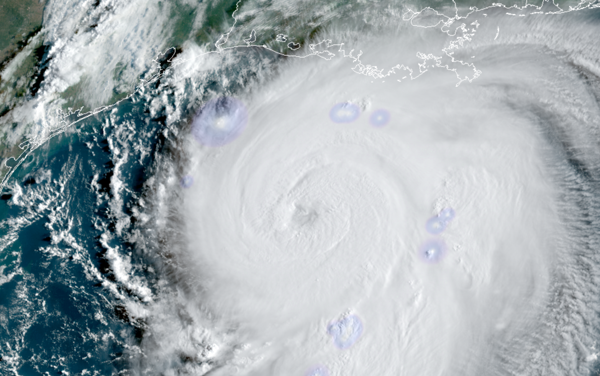
Dangerous hurricane Laura quickly approaching TX/LA coasts
Hurricane Laura strengthened into a major Category 3 hurricane this morning, and the system is still strengthening as of early this afternoon. The National Hurricane Center forecasts the storm to make landfall as a powerful Category 4 hurricane from later tonight into Thursday morning. The storm will pose a significant threat to life and property along the Texas and Louisiana coasts.
Latest observations and trends
Hurricane Laura began rapidly strengthening last night, and has continued to do so this morning. Satellite data shows a powerful hurricane, with cold cloud tops marking intense convection and favorable outflow channels allowing the storm proper ventilation.
Airplane recon data collected from the most recent pass in the storm shows continued strengthening. Maximum sustained winds at both flight level and estimated at the surface have increased. The storms pressure is falling and cloud tops are warming as Laura tries to clear out an eye.
Secondary wind maxima slightly further away from the main eyewall suggested the possibility that the storm may eventually undergo an eyewall replacement cycle, but recent trends suggest that the wind field may simply just temporarily become larger. Concentric eyewall features have not yet been observed.
An eyewall replacement cycle occurs when convection develops outside the hurricanes eyewall and becomes more robust and organized – just enough so to remove some of the intensity of storms within the eyewall itself. The original eyewall then proceeds to collapse, and a new eyewall (usually a larger one) develops from the new thunderstorms.
Eyewall replacement cycles are relatively commonplace in strong hurricanes, but we don’t truly have a complete understanding of them yet. Sometimes, stronger hurricanes don’t undergo eyewall replacement cycles as frequently as we think they will – instead, stronger thunderstorms outside the eyewall simply merge into the original eye.
If an eyewall replacement cycle does take place with Laura over the next 12 hours or so, the structure of the storms core would slightly change. Intense winds within the eyewall would decrease ever so slightly (ex: from 130 to 120mph), but the radius of the strong wind field would expand. While eyewall replacement cycles often weaken the intensity of the most severe winds, they allow “still-severe” winds to expand outward from the storms center.

It remains to be seen if an eyewall replacement cycle will occur with Laura today. In reality, the storm may not have enough time to begin or complete one. But satellite trends and observations will be continually monitored as the storm continues to evolve through this evening.
More reading on eyewall replacement cycles is available here.
The forecast for Laura over the next several hours features continued strengthening. The National Hurricane Center expects the storm to reach Category 4 status before it makes landfall along the Texas or Louisiana coastline. There is some hope that strengthening southwesterly wind shear could at least disrupt the storm as it approaches the coast, but the storm is still expected to maintain wind speeds as high as 145 miles per hour as it reaches the coastline.
Significant threat to life and property as Laura makes landfall
Hurricane Laura is forecast by the National Hurricane Center to make landfall as a dangerous Category 4 hurricane. Maximum sustained winds over 135 miles per hour will be capable of producing widespread damage and destruction. In addition, catastrophic storm surge from 9 to 15 feet above ground is forecast along parts of the Texas and Louisiana coast – an additional threat to life and property.
From the National Hurricane Center: “Unsurvivable storm surge with large and destructive waves will cause catastrophic damage from Sea Rim State Park, TX to Intracoastal City, LA.”

As it stands this afternoon, the landfall location of Hurricane Laura appears likely to be somewhere between Port Arthur, TX and Lake Charles, LA.
Residents in the path of Laura are urged to follow the advice of local governments and heed evacuation warnings and requirements. If you are still in the area and live along the coast, it is too late to make hurricane preparations – now is the time to evacuate.
For the latest, we recommend heading to the National Hurricane Center website and reviewing their latest briefings.


Leave a Reply
Want to join the discussion?Feel free to contribute!