-2")
NYC Forecast: Severe thunderstorms possible on Thursday
After a dry and cool day on Wednesday, an active weather pattern will return. Strong and severe thunderstorms are possible on Thursday. The Storm Prediction Center has highlighted the region in an Enhanced Risk for severe weather. Unsettled weather will persist into the weekend, with additional severe weather possible on Saturday.
QuickCast
This afternoon: Calm, pleasant and noticeably less humid. Temperatures will end up near seasonal averages, but lower dew points will lead to comfortable conditions. Northwest winds are expected throughout the day.
Tonight: Clouds will increase later in the evening and a few showers are possible overnight as a warm front passes the area. Temperatures will drop into the middle to lower 60’s.
Thursday: A warm front passes the area in the morning, with warm weather and dramatically increasing dew points. During the afternoon, severe thunderstorms are possible. Highs will reach the lower 90’s.
Briefing: Severe storms expected on Thursday
A heightened risk for severe weather will exist on Thursday throughout New England. A warm front will lift northward into Central NY State during the late morning and early afternoon hours. As it does so, instability will dramatically increase near and to the south of the front.
This instability will be aided by the presence of an EML, or Elevated Mixed Layer. An EML is a capping layer of well-mixed air that creates an inversion aloft. This can help prevent early-day thunderstorm activity and lead to increased instability. The same will be true on Thursday, with forecast models suggesting moderate to strong instability in New England.

More importantly, notable wind shear will also exist along the front. 50-60 knots of northwest winds are expected in the mid levels of the atmosphere. This will allow for thunderstorms to quickly become organized, and given the thermodynamic environment in place, they will quickly become strong and severe.
From a technical perspective, forecast soundings raise a lot of red flags for a notable event. The presence of an EML with ample instability and strong wind fields immediately catches the eye. Additionally, impressive 0-3km CAPE (150-200j/kg on area-averaged soundings) and hodographs further back the potential for significant-level hail and wind. The tornado potential near the warm front remains a bit more unclear, but if storms can remain discrete or interact with any seabreeze fronts later, low level shear may be sufficiently enhanced to promote tornadoes.
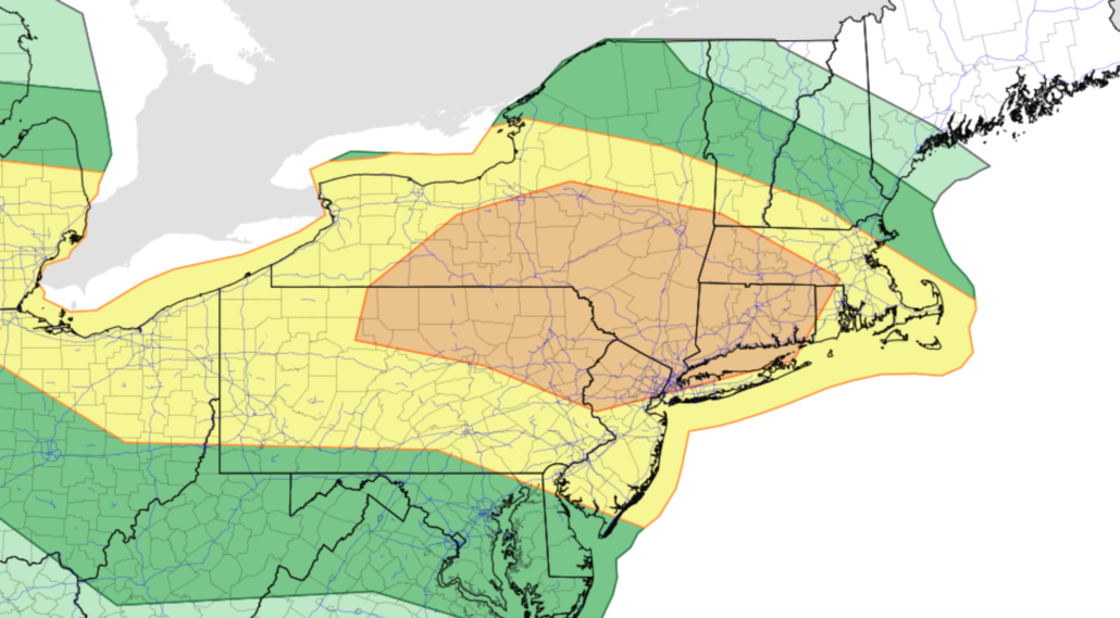
Accordingly, the Storm Prediction Center has placed much of New England, including parts of Northern NJ and NYC, in an Enhanced Risk for severe thunderstorms on Thursday. This includes a 5% risk for a tornado, a 15% risk for hail, and a 30% hatched risk for significant wind within 25 miles of any point.

The hatched risk areas are particularly notable as they are quite uncommon in New England. Typically, the Storm Prediction Center issues these hatched/signfiicant risk areas over the Plains or Central United States, where significant severe weather more frequently occurs. The hatched hail and wind outlooks suggest the possibility of significant level hail (2 inch diameter or larger) and significant wind (75mph winds or higher).
Thursday: Hazards, timing, details
Storms are likely to develop across Northern Pennsylvania and Central New York first, and then progress southeastward through New York State near/along a warm front. Additional storms will develop further south in the warm sector and move southeastward into parts of Northern New Jersey, the Hudson Valley, and Connecticut.
Thunderstorms that develop will be capable of all severe weather hazards including tornadoes, large hail and damaging winds. Storms will eventually organize into bowing lines or segments capable of widespread wind damage. As mentioned, storms from New England will eventually drop southward towards the Hudson Valley and NYC Area.
Initial storms will develop during the early afternoon (2-3pm) across New England. These will shift southward gradually, impacting parts of the Hudson Valley and Connecticut by 4-6pm. They are expected to drop southward into the NYC region after that, probably closer to sunset.
Preparedness and safety tips
Widespread severe weather events are not that common in New England, so it is worthwhile to take some time and revisit severe weather safety precautions:
- Be sure that you have a way to get weather warnings
- Know where you will go if you need to shelter from severe storms
- Check in on children and the elderly during the day and if storms develop
- Have a backup plan with supplies in case you lose power
What direction will these storm be moving in?
Storms are expected to move southeast throughout the day after starting in NY state.