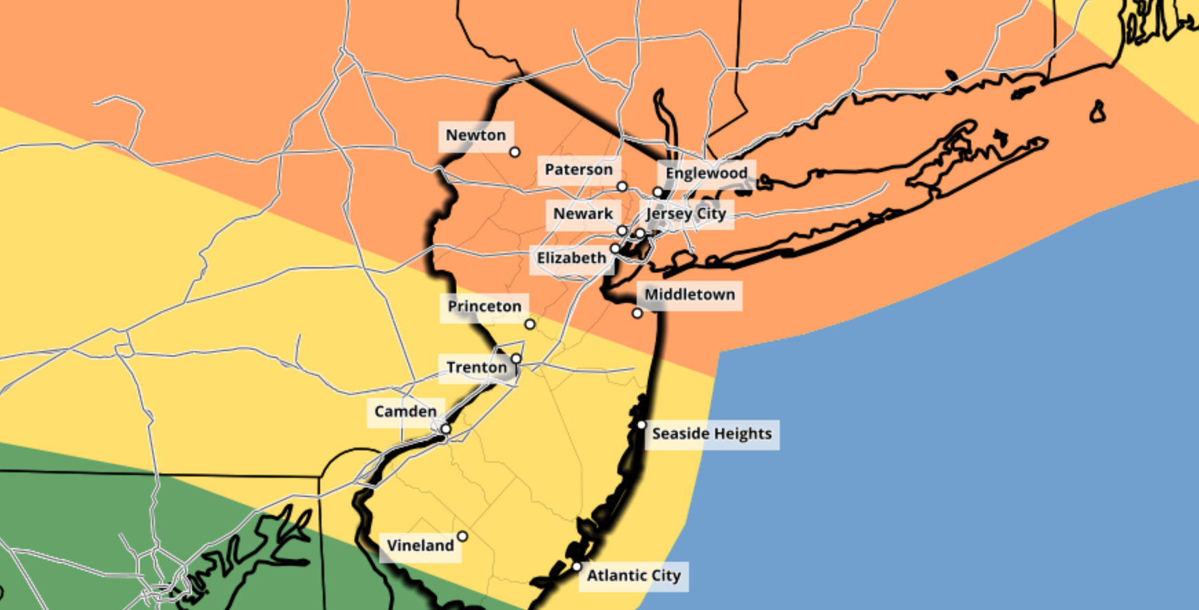
Enhanced Risk for severe thunderstorms in the Northeast today
Briefing: Showers and thunderstorms will develop this afternoon throughout New England. The combination of ample atmospheric instability and strong shear will lead to severe thunderstorms. These storms will be capable of producing strong winds, large hail, and a few tornadoes.
Timing: Initial thunderstorm development will occur between 1pm and 2pm across the Central New York capital region. These storms will quickly progress south and east along a warm front, towards the Lower Hudson Valley. Storms will reach Western Connecticut by mid-afternoon. Additional development will occur in the Lower Hudson Valley, movieg toward Long Island during the late afternoon and early evening.
Hazards: Damaging winds and large hail are the main threats, but a few tornadoes cannot be ruled out. Dangerous lightning and torrential rain is also expected.
Technical: Complex setup this afternoon
Mesoscale analysis this morning shows a warm front pushing northward through New England, with a moist and unstable airmass trailing it across the Mid-Atlantic states. Moisture advection in the mid/low levels of the atmosphere is increasing behind this front and will continue to push towards Central New England as the morning goes on. Forecast model guidance has been bouncing back and forth with the positioning of the effective warm front later today. Most recent guidance has settled in on a position near the New York Capital region.

There are some showers and thunderstorms ongoing along the warm front this morning as well. These are expected to persist in parts of Northern and Eastern New England, keeping many of those areas stable throughout the late morning and early afternoon. Gradually, the Capital region of New York, Lower Hudson Valley, and parts of Western Connecticut and Massachusetts should see clearing skies and increasing instability today.
Later this morning, atmospheric disturbance will shift into New England from Southeast Canada. This disturbance is easily recognizable on most recent short term models and observations. Height falls and lift associated with this disturbance are expected to aid in the development of thunderstorms later today.
The atmosphere near and south of the warm front will be characterized by moderately unstable air and impressively strong deep layer wind shear. Forecast soundings suggest mixed layer CAPE values over 2000 j/kg in some locations, juxtaposed nicely with 40-60kts of effective bulk shear. Some curving of low level wind fields is also present.

What does all of this suggest? In a nutshell, we can expect the development of strong to severe thunderstorms by early afternoon – and they should have no problem becoming organized and severe quite quickly. Supercells are possible initially, especially in the Capital region of New York. These storms will be capable of all severe weather hazards including a few tornadoes, large hail, and strong winds.
That leads us to around 4pm. From that point forward, uncertainty increases quickly. It remains unclear exactly how organized storms will be, and whether or not bowing clusters or segments can organize. Veering wind profiles and shallow low level moisture on some forecast soundings in the warm sector suggest that while wind damage is possible, storms may tend to remain a bit unorganized once they pull southward off the warm front. This means that we could see outflow boundaries or gust fronts surging southward from storms themselves, ending the severe weather threat for areas to the south.
If storms do organize – and perhaps a cold pool can organize in one or more complexes of storms – then a more substantial/widespread damaging wind event would be possible. Otherwise, individual storms near the warm front will be capable of all severe hazards before outflow boundaries and gust fronts begin to stabilize the atmosphere near/south of the front later in the afternoon.

Overview and what to expect
The main focus area for severe weather potential remains relatively unchanged, and in fact has become a bit more clear since yesterday. This focused area of potential arcs from the Capital region of New York southeastward into the Lower Hudson Valley. It then continues into parts of Western Connecticut. Damaging winds, hail, and a few tornadoes are expected in this region.
Further south, the severe weather potential remains more unclear. The possibility exists that gust fronts and outflow boundaries (winds being pushed out from other storms) could stabilize the atmosphere in this region and negate a more substantial threat. Still, isolated to scattered damaging wind and hail is possible this afternoon.
The Storm Prediction Center maintains an Enhanced Risk of severe weather for much of the aforementioned region.
Stay weather aware throughout the entire highlighted threat region and have a way to get weather warnings. If a warning is issued for your area, know where to go in your home to be safe until the storm has passed.


Trackbacks & Pingbacks
d
3fatherly
Leave a Reply
Want to join the discussion?Feel free to contribute!