-2")
Hurricane Teddy could prove to be a major forecasting challenge
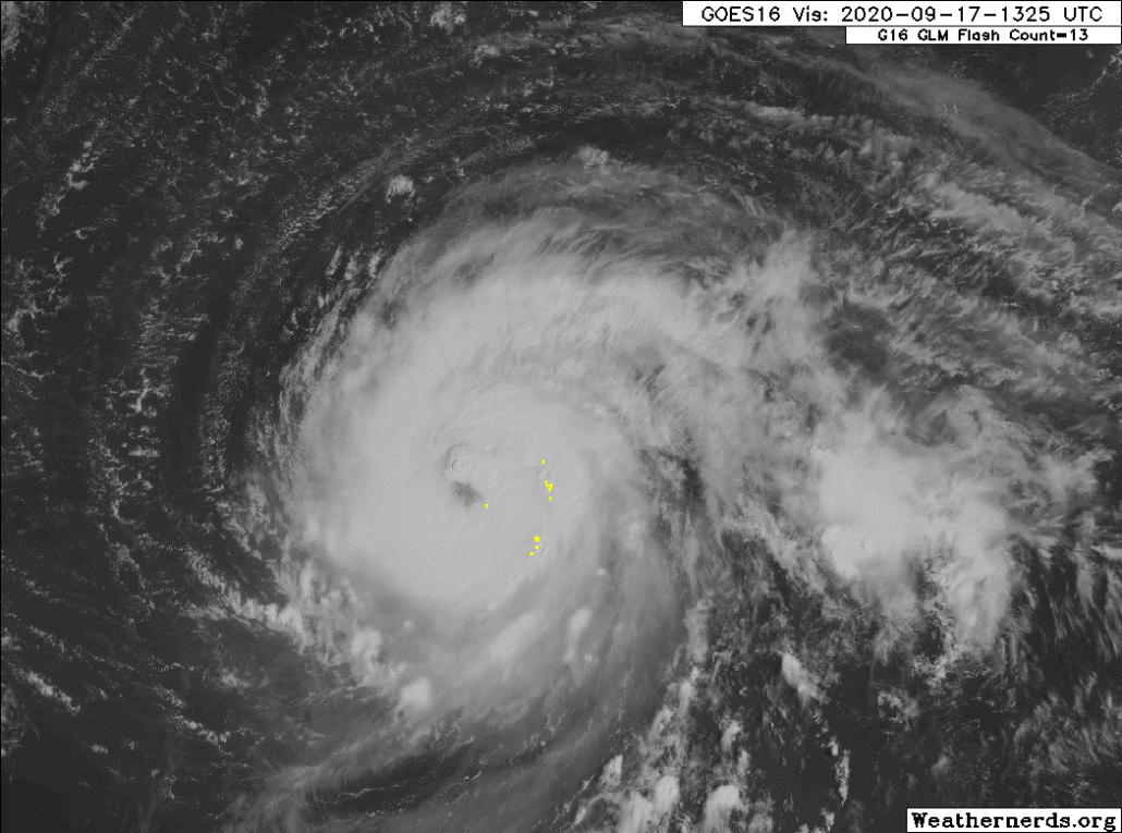
Hurricane Teddy continues churning in the Atlantic this morning, with maximum sustained winds of 105mph. The storm has strengthened, and recent satellite imagery shows continued bursts of impressive convection near the storms center. The National Hurricane Center forecasts Teddy to strengthen to a major hurricane later today.

Satellite imagery this morning shows continued impressive convective bursts around the center of Teddy. Westerly wind shear can still be observed, but the cyclone is powering through both wind shear and some dry air to its north and northwest. Over the past few hours, very impressive convection and vertical hot towers have been observed near the storms inner core. Accordingly, the forecast is for general strengthening to Category 3 (Major) strength over the next few days.
Teddy is forecast to move over some cooler waters, which were overturned by the passage of Hurricane Paulette a few days ago, by this weekend. This, combined with some wind shear and dry air aloft, could cause Teddy to enter a temporary weakening phase. NHC forecasts the storm to weaken back to Category 2 strength later this weekend as a result.
Bermuda could be impacted again
Teddy will continue moving steadily northwestward over the next few days. The storm will be steered by a mid level ridge, which is positioned to its northeast. The synoptic pattern won’t change much through the weekend. This places Teddy on a concerning track, moving in the general direction of Bermuda.
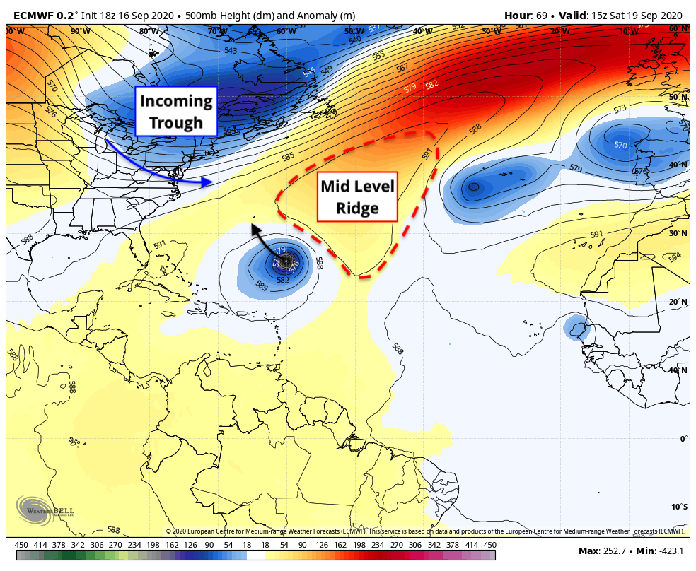
By this weekend, ensemble guidance indicates that Teddy will reach a critical inflection point. The ridge to the northeast of the cyclone will start to erode, allowing for the storm to turn more north-northwest. The most recent data suggests that this turn could occur near or perhaps just east of Bermuda.
Impacts in Bermuda remain a tremendous uncertainty at this time. There are several uncertainties – including the track of Teddy, its movement over cooler waters that were overturned by Paulette, the resulting intensity of the system, etc. Nevertheless, a general blend of deterministic and ensemble guidance suggests that the risk for some impacts in Bermuda is rising.
Accordingly, residents of Bermuda should make early preparations for a potential tropical storm. Pay close attention to the forecast over the next few days.
After Bermuda, Teddys future grows extremely uncertain
Regardless of what happens as Teddy passes near the latitude of Bermuda, the longer range forecast regarding the cyclone becomes extremely complicated. There are several variables in the synoptic pattern that could lead to an usual track of the cyclone early next week.
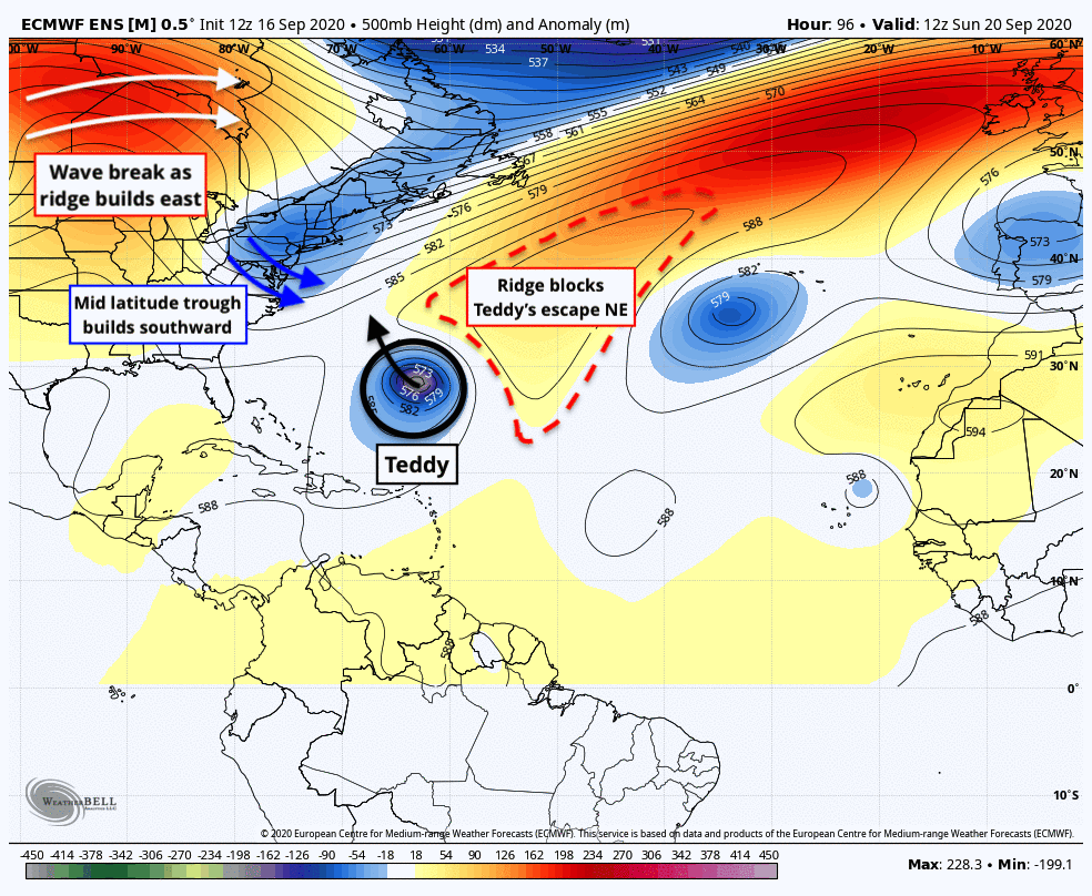
Some of the most important features are highlighted above. A trough will move eastward from the Northeast states into the Northwest Atlantic. A ridge, associated with an anticyclonic wave breaking event, will push over the top of this trough and into Eastern Canada. Meanwhile, Teddy will head northward past Bermuda, without much of an eastward escape route.
This “squeeze play” that ensembles are hinting at raises many meteorological eyebrows. Some guidance, including the ECMWF and ECMWF EPS, suggest that Teddy will phase with the disturbance moving out of New England and be tugged north and northwestward to a position near or east of New England.
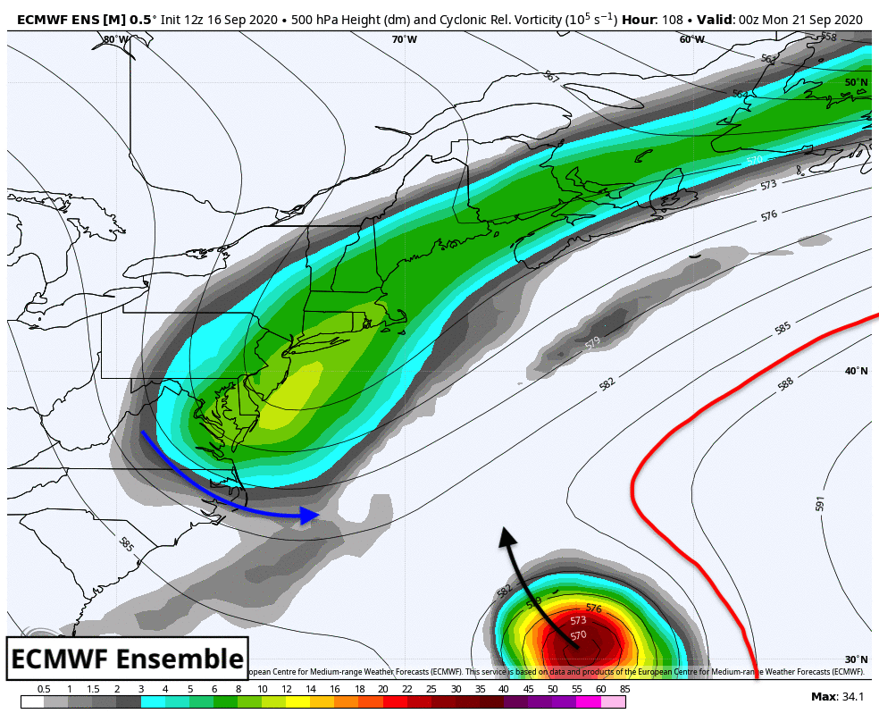
Other guidance, including the GFS suite, remains more progressive with the evolution of troughing in New England overall. Teddy is slower and further south, and as a result can “wait” for the trough to pass before heading north and northeast harmlessly out to sea. You can see these differences clearly when comparing the two ensemble suites.
The entire evolution of Teddy after it passes Bermuda remains highly uncertain. With that said, there are a few key factors that we can closely monitor over the next few days:
- What occurs with the track and intensity of Teddy in the next few days? Where does the storm itself end up, how strong is it, and how fast is it moving compared to what ensemble guidance is suggesting today?
- How amplified is the trough moving out of New England? The GFS is much more progressive with this feature than the ECMWF suite, resulting in a more progressive evolution of Teddy overall
- How does the wave-breaking event in Eastern Canada evolve? The ECMWF EPS suggest an anomalous ridge eventually builds over the top of Teddy, while the GFS entertains a completely different – and more progressive – orientation
Should the interaction between the mid latitude trough and Teddy occur as the ECMWF guidance suggests, a dynamic storm system could develop. Such a scenario, with a phase between a mid latitude trough and tropical system, could lead to a strong storm moving northward towards Eastern Canada or perhaps even Eastern New England.

Such a phase and storm system would be anomalous, but not unprecedented. A phase or interaction east of New England would obviously introduce the discussion of hazardous weather impacts along parts of the New England and Eastern Canada coast as well.
For now, it is best to focus on what we know in regards to Teddy – which is that the storm will continue on a northwest heading while slightly strengthening. As the storm moves closer to Bermuda in the coming days, we should begin to get a clearer picture as to how various atmospheric pieces will evolve, leading to increased confidence in regards to Teddy’s eventual track.
Trackbacks & Pingbacks
2dressing
Leave a Reply
Want to join the discussion?Feel free to contribute!