-2")
NWS confirms derecho in New England on October 7
The National Weather Service has confirmed that a derecho occurred in New England on October 7th, 2020. More than 200 damaging wind reports were received from New York to Massachusetts. The event was officially classified as a derecho after re-analysis confirmed a 320 mile long damage swath and multiple 75+mph wind gusts.
What is a derecho?
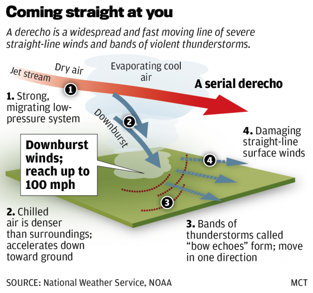
NOAA officially defines a derecho (pronounced “deh-REY-cho”) as “a widespread, long-lived windstorm that is associated with a band of rapidly moving showers or thunderstorms.” They occur most frequently in the summer months, especially in the Midwest where the combination of atmospheric instability and wind shear can lead to fast moving lines of storms. The most recent derecho to make headlines occurred in Iowa this summer, where billions of dollars in damage occurred.
Not every line or complex of storms is classified as a derecho. To make things more confusing, the official classification of a derecho is often misinterpreted and poorly reported. NOAA’s official derecho classification requires both of the following to occur:
- A damage swath of at least 250 miles
- Multiple wind gusts over 60mph throughout the extent of the damage swath
The high-end severe weather event on October 7th, 2020 met both of these criteria. With a path length of 320 miles, widespread damage reports, and multiple wind gusts over 70mph the event easily meets derecho criteria. In fact, it was the most impressive severe thunderstorm event of the year to date in New England.
Derecho’s are uncommon, but not unheard of in the Northeast United States. In June, a derecho impacted parts of Pennsylvania and New Jersey. In 2018, another derecho impacted the Northern Mid Atlantic. A derecho roared from the Ohio Valley through Washington, DC in 2012. For historians or old folks like myself, you’ll remember the Labor Day Derecho from 1998.
Nevertheless, the event on October 7th, 2020 was impressive. Wind gusts to 70mph were observed in parts of New York State, Connecticut and Massachusetts. Perhaps most impressive of all is the fact that the derecho occurred “out of season”. How did such a powerful line of thunderstorms develop in October?
Technical breakdown: How the derecho happened
A few days prior to the event, it became apparent that an anomalous storm system would impact New England. Forecast models were in good agreement that a strong low pressure system would develop in Eastern Canada. More notably, they were also suggesting a powerful mid level jet streak would surge into the Northeast States.
The morning of the event, the NAM model suggested that a 100+kt jet streak would move through New England during the afternoon hours. The powerful winds in the mid levels of the atmosphere were supportive of the potential for strong wind gusts. The downward transfer of momentum could be enhanced by any thunderstorms that formed.
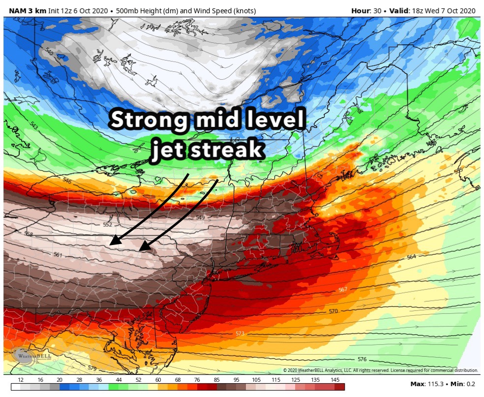
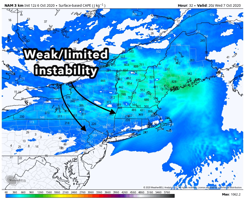
By the late morning hours, a warm front began to lift northward through the Capital Region of New York and towards Vermont. South of this front, atmospheric moisture and instability began to increase. As a disturbance approached the area from the west, the environment in place was characterized by weak instability (CAPE values 250-500j/kg) and high shear (100+kt mid level jet streak).
The presence of three key ingredients for a severe thunderstorm event would occur by the early afternoon:
- Lift to help develop storms (via the approaching mid level disturbance)
- Instability (weak, but sufficient for storm organization)
- Wind shear (very strong mid level jet streak)

Thunderstorms quickly developed in Western New York and began to move quickly eastward. The environment ahead of them remained supportive of storm organization and maintenance. These storms began to mix down the very strong winds which were present a few thousand feet above the surface, and strong wind gust reports began flowing in.
By the mid-afternoon hours, the complex of storms began shifting quickly eastward into New York State, reaching the borders of Vermont, Connecticut and Massachusetts. Multiple 70+mph wind gusts occurred. Albany International Airport reported a wind gust to 69mph.
By evening, the storms continued their trek towards the New England coasts. Gusts over 60mph were still occurring as the storms picked up momentum. Eventually, the complex of storms would clear the coast and head into the waters of the Atlantic.
Assessing the damage
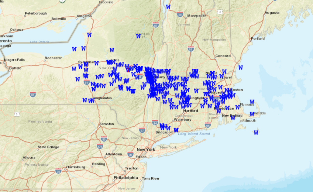
By the time all was said and done, the derecho left a damage swath longer than 300 miles. Multiple wind gusts reached higher than 70 miles per hour. Two tornadoes were confirmed. By all measures, it was an extremely impressive event and likely the most impactful severe thunderstorm event in New England this year.
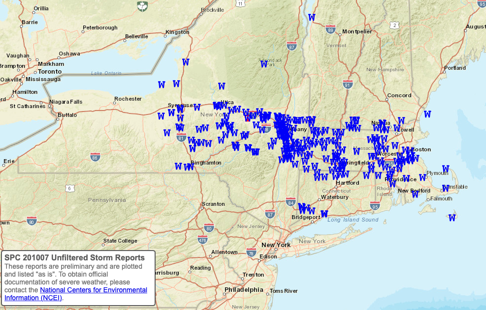
The Storm Prediction Center received well over 200 reports of damaging wind gusts. Mapping out those reports, we can clearly visualize the path of the derecho beginning in Western New York and ending on the coast of New England.
While not unheard of, a derecho occurring in New England during the month of October is rare. It speaks to the dynamics of this impressive storm system, and serves as a nice reminder that severe weather events can occur at any time of the year if the dynamic setup and atmospheric ingredients allow.
Trackbacks & Pingbacks
1midsummer
Leave a Reply
Want to join the discussion?Feel free to contribute!