-2")
Coastal storm could bring myriad of weather hazards late week
As fog and drizzle continues in the NYC Metro Area this afternoon, the weather pattern to our west is becoming increasingly amplified and active. This includes record-breaking cold in the Plains and Tropical Storm Zeta in the Caribbean. Later this week, the two disturbances could phase and result in an impressive Nor’Easter.
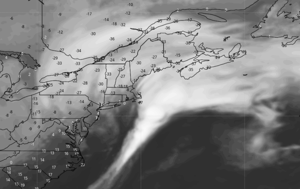
The synoptic weather pattern this afternoon is quite impressive and anomalous. Record breaking cold air and a deep trough are currently located in the Plains states, where snow and ice are occurring. Temperatures in some areas have fallen 40 degrees below normal. Meanwhile, Tropical Storm Zeta is strengthening while moving near the Yucatan.
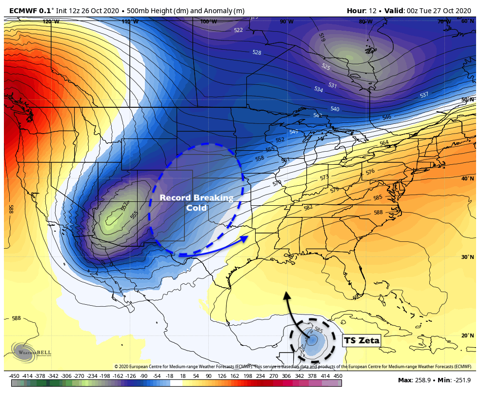
Recent forecast model data suggests that the upper level low over the Plains will drift eastward into the Mississippi River Valley by the middle of this week. Meanwhile, Tropical Storm Zeta is forecast to move into the Gulf of Mexico, eventually making landfall in Louisiana. As it moves northward, the remnants of the system will interact and phase with the aforementioned upper low.
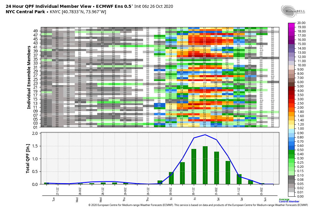
As this occurs, tropical moisture will expand northward into the Tennessee and Ohio Valleys, eventually moving into the Mid Atlantic. Bands of moderate to rainfall should expand into the NYC Area on Thursday as well, with the potential for heavy rain and localized flooding.
Ensemble data suggests that rainfall totals on Thursday in the NYC Area could exceed 1-2″. Atmospheric dynamics will be impressive, and when factoring in the tropical moisture advecting into the region from Zeta, the heavy rainfall potential becomes clear. Flood advisories may eventually be needed if this overall evolution looks more likely in the coming days.
Rainfall could be locally enhanced by the gradient between cold air pressing to our north, and the tropical moisture advection moving in from the south. This helps to add in “convergence” in the atmosphere, tightening up frontal boundaries and adding in locally heavier rainfall rates.
Winter weather possible in New England
Perhaps the most interesting facet of the late week storm system will be the potential for winter weather in New England. As the storm evolves towards the Northeast states, it will begin to encounter anomalously cold air over Southeast Canada. A deep trough there may partially interact with the system, too, allowing additional cold to bleed southward into New England.
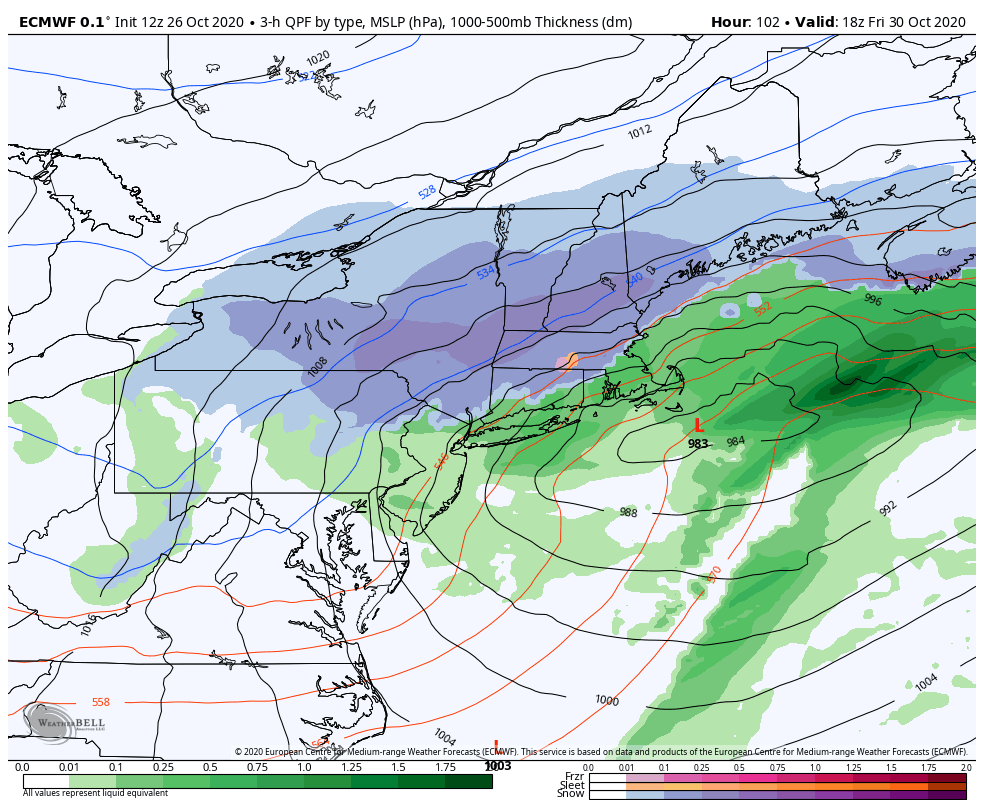
A secondary low pressure area is likely to redevelop off the Northeast US coast. Cyclonic flow around the developing storm plus the anomalous cold to the north suggests that the first winter storm of the season could occur in New England. This currently appears most likely in parts of Central New York State, Vermont, New Hampshire and Maine.
However, depending on the intensity of the coastal storm, cold air may work its way even further south. Recent runs of the Euro Ensemble suggest low to moderate probabilities of 1″ of snow as far south as the suburbs of New Jersey, Southeast New York and Connecticut. This appears most likely on the back end of the storm, when cold air bleeds southward and atmospheric dynamics aid in additional cooling.
We’ll be closely monitoring the forecast in the coming days, including the potential for both flooding rainfall and wintry weather in the suburbs, as well as more significant wintry weather in Northern New England.
Just started playing Sprunki Talking Vineria Wenda and Pinki and I’m already noticing some cool mechanics. Anyone else having trouble with the timing windows? Still, the core gameplay vibes are solid.
As someone who’s played many Sprunki mods, Sprunki Talking Vineria Wenda and Pinki finally nails the difficulty curve. The new mechanics add strategic depth without being overwhelming. GG to the devs!
As a long-time Sprunki fan, I appreciate the polish in Sprunki Phase 9 GGTP V2. The sprite work is cleaner and the controls feel tighter than previous versions. Worth the grind!
Hey very cool web site!! Guy .. Beautiful .. Superb .. I will bookmark your site and take the feeds additionally…I am happy to search out numerous helpful info here in the submit, we’d like develop extra techniques in this regard, thank you for sharing.