-2")
NYC Forecast: More rain Sunday, much warmer weather late week
The sun will set in NYC at 5:53pm this evening, the last sunset after 5pm until late January of 2021. Daylight saving time ends tonight at 2am, and sunset on Sunday is at 4:51pm. Now that we’ve gotten that misery out of the way, let’s talk about the weather.
QuickCast: Rain likely on Sunday with dreary weather. Cold and windy Monday with a chance of snow showers. Improving and much warmer weather later in the week.
Pleasant but cold weather dominated the region today. High temperatures only reached the middle 40’s, more than 10 degrees below normal. There was plenty of sunshine though, which is a welcomed addition to our days that have been mostly filled with clouds and rain over the last week.

The clouds and rain will make their grand return to the forecast on Sunday, as another area of low pressure develops near New England. Clouds will increase tonight, with drizzle and showers becoming likely by Sunday morning. A period of steady rain is anticipated from late morning into the afternoon hours, as moisture streams northward along the coast.
The heaviest rain will likely be near the coasts of New Jersey and New York, including Long Island. While the most substantial rainfall totals will be east of the NYC Metro, much of the day will be unpleasant and feature sporadic rain. Temperatures will reach the middle 50’s, but will quickly fall thereafter.
Flakes possible Monday, much warmer late week
In the wake of a strengthening low pressure system in New England, northwesterly winds will really ramp up on Monday. Highs will only reach the low to middle 40’s, with stiff northwest winds keeping real-feel temperatures in the 30’s in many regions.
Of additional intrigue will be the potential for snow showers. Lake-effect bands may develop and impact parts of Pennsylvania, New York and New Jersey. Forecast soundings show enough moisture and lift for these bands – and perhaps a few additional scattered snow showers – to make it into the NYC Metro. It’s possible that we see our first flakes of the season flying on Monday.
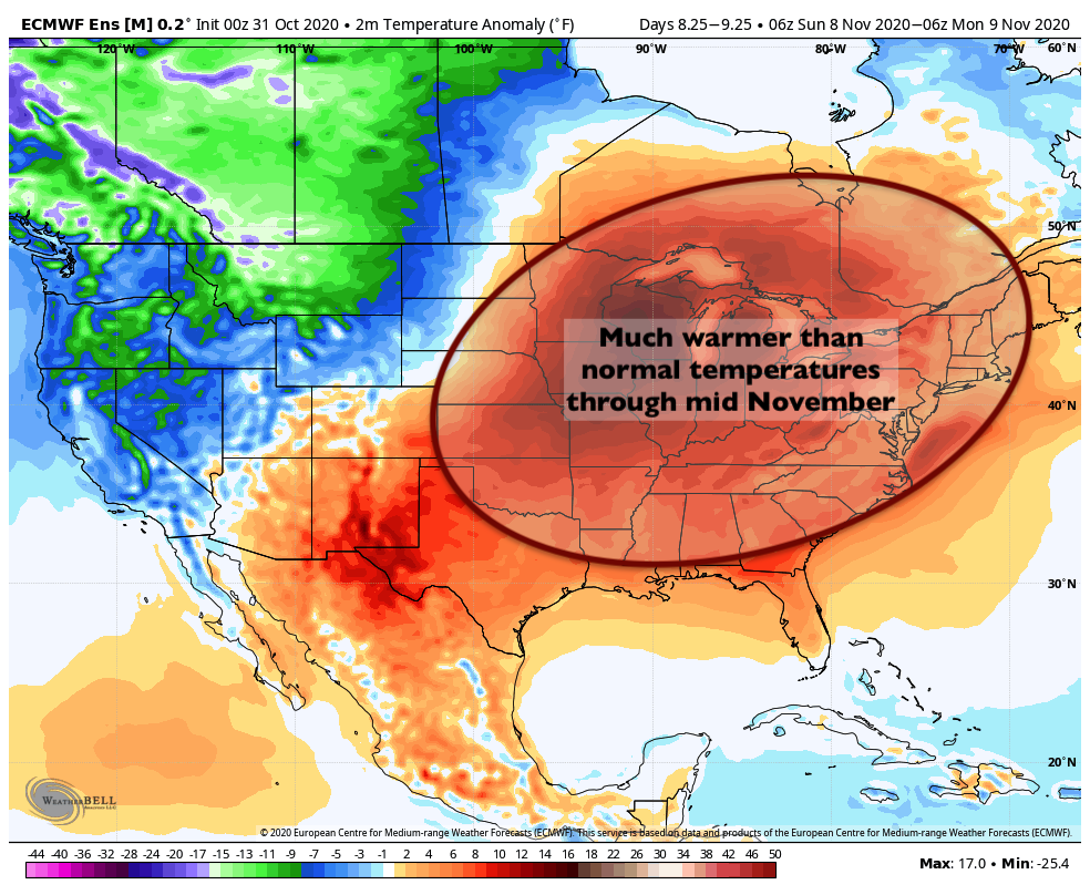
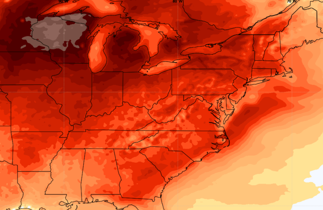
After this deep trough moves out of the area, temperatures will gradually warm up through the middle of the week. In fact, most ensemble guidance agrees that by the middle and end of the week, temperatures will trend rapidly above normal. A large ridge will build overhead with warmer air advecting in from the Central United States.
By Thursday and Friday, temperatures could reach 15 to 20 degrees above normal, with highs in the upper 60’s to near 70 degrees (!). This anomalous warmth looks likely to continue through the weekend and may even rebound into the week afterward, leading us towards the middle of the month of November in a very warm pattern.
baran aydin
baran aydin
türk kahvesinin faydaları
Wow! This can be one particular of the most useful blogs We have ever arrive across on this subject. Actually Great. I am also a specialist in this topic therefore I can understand your effort.
Güncel istanbul hurda fiyatları ile İstanbul’da hurda alan yerler içerisindeyiz. Size en yakın istanbul hurdacı firması olarak hizmet sunuyoruz. En yakın hurdacı firmamıza hurda satabilirsiniz.